North Vista Trail, Black Canyon of the Gunnison National Park
Colorado > Black Canyon of the Gunnison National Park > Hiking > North Vista Trail
North Vista Trail
Lightly used but easy-to-follow path that winds through wooded terrain on the North Rim of Black Canyon, past one fine overlook (Exclamation Point) then climbs to the highest summit in the park, 8,563 foot Green Mountain
Length: 3.5 miles, including the spur to Exclamation Point
Elevation change: 800 feet
Difficulty: Easy to moderate
Type: One way
Usage: Low
Season: Spring, summer, fall
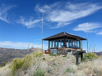
Trailhead: At the North Rim ranger station
Rating (1-5): ★★★★★
Elevation change: 800 feet
Difficulty: Easy to moderate
Type: One way
Usage: Low
Season: Spring, summer, fall
Trailhead: At the North Rim ranger station
Rating (1-5): ★★★★★

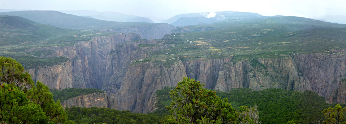
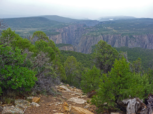
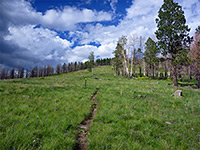
Trails in Black Canyon of the Gunnison National Park are either level, running along the canyon rim, or steeply descending, dropping 1,800 feet or more to the Gunnison River; the only one to climb significantly is the North Vista Trail, on the less-visited North Rim. From the ranger station, the path crosses a bushy area and follows the canyon edge westwards, past a short spur to a spectacular overlook (Exclamation Point) then veers away to the north, climbing 800 feet to part of the elongated summit of Green Mountain, at 8,563 feet the highest location in the park.
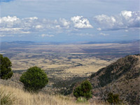
Most of the route is through woodland, and the summit is also partly forested so the views are limited, but the south and east parts of the canyon are clearly visible in some places, while the end of the trail has long views north, towards Delta and the lower Gunnison valley. Although the path is rarely traveled, especially beyond Exclamation Point, the route is easy to follow and never particularly steep.
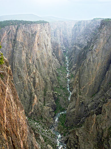
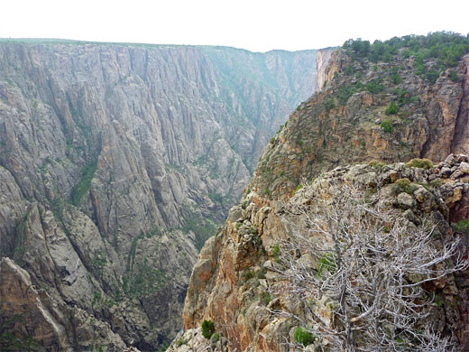
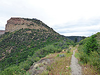
The North Vista Trail shares a parking lot with the North Rim ranger station. The path sets out across a sagebrush flat, bordered to the north by a low but steep slope, the edge of a mesa, of which Green Mountain forms the highest point, 2 miles west. The trail curves around the head of a drainage, through a grove of small oak trees, where the rough SOB Draw route branches off, descending 1,800 feet to the Gunnison River. Beyond are several other small streamways, crossing patches of red and cream slickrock, in contrast to the predominant dark grey of most of the rocks hereabouts. The ground rises a little then levels out again, covered now by rather taller woodland of oak and pine. A signed junction after 1.2 miles marks the start of the 0.3 mile spur to Exclamation Point, which ends in a very short loop right along the canyon rim, 1,900 feet high. The best views here are upstream, along a lengthy, narrow, straight section of the river, somewhat reminiscent of Tuweep in the Grand Canyon; most of the gorge downstream is hidden behind protruding rocks.
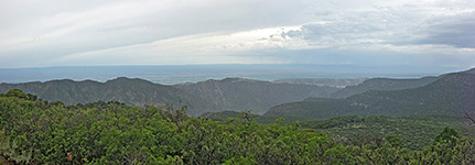
The path veers away from the canyon after the Exclamation Point junction, and following some gentle climbing, reaches a relatively level area, crossed by a few more minor drainages, all the while enclosed by the same, tall, mixed woodland. The final, steeper part of the hike begins soon after, ascending via a short series of long switchbacks, as the surrounding land starts to look like a proper hill for the first time, rather than a gentle, featureless slope. Gaps in the trees allow good views of the canyon to the south and east. The path ends with a short loop around the bushy mesa top (Green Mountain), where the main viewpoint is to the northwest, looking across forested ridges and valleys towards Delta. Overall, the trail is not particularly exciting, but it provides the only elevated views of Black Canyon, a vista that on clear days extends many miles east, well into the adjacent Curecanti National Recreation Area.
Most of the route is through woodland, and the summit is also partly forested so the views are limited, but the south and east parts of the canyon are clearly visible in some places, while the end of the trail has long views north, towards Delta and the lower Gunnison valley. Although the path is rarely traveled, especially beyond Exclamation Point, the route is easy to follow and never particularly steep.
Exclamation Point
The North Vista Trail shares a parking lot with the North Rim ranger station. The path sets out across a sagebrush flat, bordered to the north by a low but steep slope, the edge of a mesa, of which Green Mountain forms the highest point, 2 miles west. The trail curves around the head of a drainage, through a grove of small oak trees, where the rough SOB Draw route branches off, descending 1,800 feet to the Gunnison River. Beyond are several other small streamways, crossing patches of red and cream slickrock, in contrast to the predominant dark grey of most of the rocks hereabouts. The ground rises a little then levels out again, covered now by rather taller woodland of oak and pine. A signed junction after 1.2 miles marks the start of the 0.3 mile spur to Exclamation Point, which ends in a very short loop right along the canyon rim, 1,900 feet high. The best views here are upstream, along a lengthy, narrow, straight section of the river, somewhat reminiscent of Tuweep in the Grand Canyon; most of the gorge downstream is hidden behind protruding rocks.
Green Mountain
The path veers away from the canyon after the Exclamation Point junction, and following some gentle climbing, reaches a relatively level area, crossed by a few more minor drainages, all the while enclosed by the same, tall, mixed woodland. The final, steeper part of the hike begins soon after, ascending via a short series of long switchbacks, as the surrounding land starts to look like a proper hill for the first time, rather than a gentle, featureless slope. Gaps in the trees allow good views of the canyon to the south and east. The path ends with a short loop around the bushy mesa top (Green Mountain), where the main viewpoint is to the northwest, looking across forested ridges and valleys towards Delta. Overall, the trail is not particularly exciting, but it provides the only elevated views of Black Canyon, a vista that on clear days extends many miles east, well into the adjacent Curecanti National Recreation Area.
North Vista Trail - Similar Hikes
All Contents © Copyright The American Southwest | Comments and Questions | Contribute | Affiliate Marketing Disclosure | Site Map