Gunnison Route, Black Canyon of the Gunnison National Park
Colorado > Black Canyon of the Gunnison National Park > Hiking > Gunnison Route
Gunnison Route
Unmaintained route vertically down the precipitous cliffs of Black Canyon, all the way to the river - aided over one 80 foot stretch by a metal chain. Loose rocks underfoot
Length: 1 mile
Elevation change: 1,800 feet
Difficulty: Strenuous
Type: One way. Starts with the first 1/3 mile of the Oak Flat Trail
Usage: Low
Season: Late spring, summer and fall
Trailhead: By the visitor center
Rating (1-5): ★★★★★
Elevation change: 1,800 feet
Difficulty: Strenuous
Type: One way. Starts with the first 1/3 mile of the Oak Flat Trail
Usage: Low
Season: Late spring, summer and fall
Trailhead: By the visitor center
Rating (1-5): ★★★★★

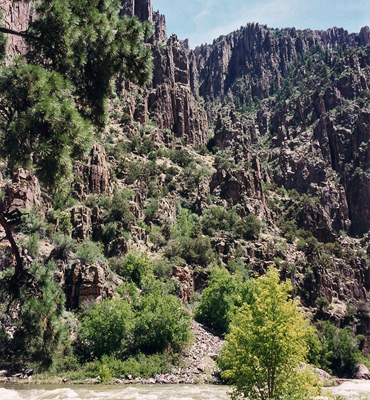
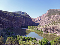
There are three routes from the south rim of Black Canyon to the Gunnison River; all are unmaintained, very steep and difficult for the inexperienced. Prospective hikers need to convince a ranger of their abilities before obtaining a free permit, which is required to make any trip into the canyon. The most popular trail is the Gunnison Route, which starts near the visitor center and for a short distance follows part of the circular, mostly level Oak Flat Trail through bushes and pine trees along the canyon rim, with only occasional views of the gorge.
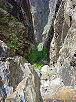
The Gunnison Route river trail branches off downwards to the north after half a mile. From this junction the land drops 1,700 feet to the river, over about the same horizontal distance. At one point a chain has been installed to aid passage over a particularly steep 80 foot section, and the majority of the route passes over boulders and loose rocks, so great concentration is required when descending. The official time taken for the descent is 90 minutes, although the trip can be done much quicker by a combination of running and controlled sliding. It is quite easy to get lost, especially when ascending (for which the suggested time is 2 hours) since the path is unmarked and not obvious, especially where it crosses rocky areas. Hikers must be careful to avoid dislodging boulders, which may easily start more concerted rock slides.
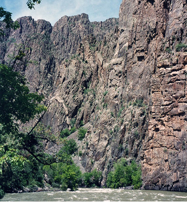
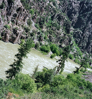
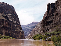
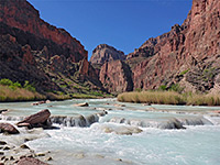
The banks of the Gunnison River are steep and overgrown, preventing any waterside trails although there is a primitive campsite 150 feet upstream, which is susceptible to flooding, especially in early summer during the peak snowmelt season. The water is always deep, fast-flowing and cold so swimming and wading are definitely not possible. The canyon walls opposite are remarkably sharp, jagged and forbidding, formed of hard black rocks that contrast vividly with the bright green vegetation.
The other two south rim paths to the river are even more strenuous. The Warner Route is twice as long and has a greater vertical descent, while the Tomichi Route is slightly steeper and has less shade and more loose rock.
The Trail
The Gunnison Route river trail branches off downwards to the north after half a mile. From this junction the land drops 1,700 feet to the river, over about the same horizontal distance. At one point a chain has been installed to aid passage over a particularly steep 80 foot section, and the majority of the route passes over boulders and loose rocks, so great concentration is required when descending. The official time taken for the descent is 90 minutes, although the trip can be done much quicker by a combination of running and controlled sliding. It is quite easy to get lost, especially when ascending (for which the suggested time is 2 hours) since the path is unmarked and not obvious, especially where it crosses rocky areas. Hikers must be careful to avoid dislodging boulders, which may easily start more concerted rock slides.
The River
The banks of the Gunnison River are steep and overgrown, preventing any waterside trails although there is a primitive campsite 150 feet upstream, which is susceptible to flooding, especially in early summer during the peak snowmelt season. The water is always deep, fast-flowing and cold so swimming and wading are definitely not possible. The canyon walls opposite are remarkably sharp, jagged and forbidding, formed of hard black rocks that contrast vividly with the bright green vegetation.
Other Routes
The other two south rim paths to the river are even more strenuous. The Warner Route is twice as long and has a greater vertical descent, while the Tomichi Route is slightly steeper and has less shade and more loose rock.
Gunnison Route - Similar Hikes
All Contents © Copyright The American Southwest | Comments and Questions | Contribute | Affiliate Marketing Disclosure | Site Map