Lava Falls Trail, Tuweep, Grand Canyon National Park
Arizona > Grand Canyon National Park > Tuweep > Lava Falls Trail
Lava Falls Trail
Very steep descent down loose scree and lava blocks, from the rim near Toroweap Overlook to Lava Rapids on the Colorado River
Length: 1.5 miles
Elevation change: 2,540 feet
Difficulty: Relatively short but very strenuous, owing to the steep gradient and the unstable ground
Type: One way
Usage: Low
Season: The hike is possible all year, but conditions are very hot in summer, and the access roads are likely to impassable during winter because of snow - and at any time after recent rainfall
Trailhead: End of a 2 mile side track branching off the road to Toroweap Overlook - 56 miles from AZ 389
Rating (1-5): ★★★★★

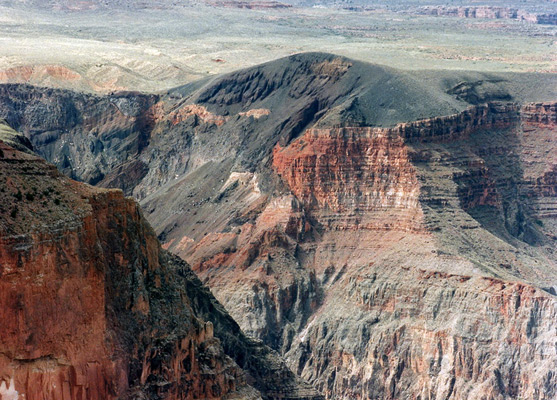
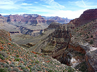
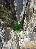
The Lava Falls Trail descends from the north rim of the Grand Canyon just west of the extinct volcano known as Vulcans Throne to the Colorado River, a drop of 2,540 feet over a distance of less than 2 miles. It is particularly strenuous and difficult owing to the lack of shade and water, the steep gradient and the unstable ground - much of the route is across sharp lava blocks and loose scree, but despite these hazards the trip is most exciting, and provides the shortest rim to river route in the national nark. Adding to the obvious dangers is the possibility of meeting rattlesnakes and scorpions, according to the NPS trail guide.
Lava Falls Trail topographic map.
Just reaching the trailhead requires some effort; after driving 7 miles south along the Toroweap Point Road that leads to the Toroweap overlook, a side-track branches west - this junction is about 3 miles from the canyon rim, shortly before the start of the more uneven end section of the main road. The narrow side track crosses the (usually) dry Toroweap Lake, then winds over several lava hills and descends through a short curving ravine to the canyon edge - a distance of 2 miles. Going is rough, and a 4WD vehicle would probably be necessary, certainly for the last section which is steep and rocky.
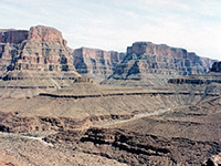
There is no shelter or other facilities at the trailhead, just a small parking area and a trail register with copies of a useful guide and route map. Only a short section of the path is visible from roads end; it curves down into a reddish-black colored, bowl-shaped depression then drops out of sight over a rocky ledge. The colors are typical of the volcanic landscape of both the north and south sides of the Grand Canyon at this point. It is a gentle 5 minute stroll to reach the first ledge, then the true character of the trail becomes evident as the route follows down a very steep gully, traverses a little way eastwards then begins a long series of switchbacks along a ridge covered with cinders and lava, ending at a flat area of red gravel, about half way to the river. The route is not always easy to follow although it is marked by cairns, which become more necessary in the lower section - the path bends east, follows a secondary ridge for a while then curves back west under a cliff face and into a ravine, even steeper than the upper slopes, and filled with loose scree and unsteady lava blocks. A wrong turn here may lead to a sheer drop-off or risk starting a rock slide.
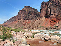
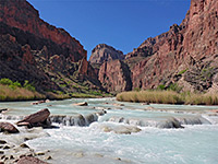
The designated route mainly follows the east side of the ravine, which extends almost all the way to the Colorado. Around the river, the temperature is markedly higher than at the rim - maybe by 10°F, and the vegetation is more desert-like, with large barrel cacti and yucca. The noise of the Lava Falls rapids is audible for most of the descent; the falls themselves are reached by walking along the river banks for 200 yards. There are several small sandy beaches, good for paddling and cooling off before the return journey.
A round trip, starting late morning on a hot, sunny August day took me 2.5 hours, or 4 hours including the extra 4 mile walk to and from the junction with the Toroweap Point Road. I had left some water at the trailhead but not taken enough for the hike, and found it best to hurry back and reach the cached supply as quickly as possible. This is certainly a hike for which a good amount of water is needed; there is none available en route as the Colorado water is unsafe to drink unless filtered. The official guide puts the round trip from the trailhead at between 4 and 12 hours.
Maps
Lava Falls Trail topographic map.
The Approach Road
Just reaching the trailhead requires some effort; after driving 7 miles south along the Toroweap Point Road that leads to the Toroweap overlook, a side-track branches west - this junction is about 3 miles from the canyon rim, shortly before the start of the more uneven end section of the main road. The narrow side track crosses the (usually) dry Toroweap Lake, then winds over several lava hills and descends through a short curving ravine to the canyon edge - a distance of 2 miles. Going is rough, and a 4WD vehicle would probably be necessary, certainly for the last section which is steep and rocky.
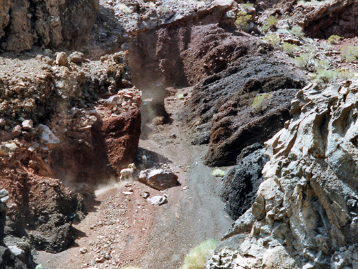
The Trail
There is no shelter or other facilities at the trailhead, just a small parking area and a trail register with copies of a useful guide and route map. Only a short section of the path is visible from roads end; it curves down into a reddish-black colored, bowl-shaped depression then drops out of sight over a rocky ledge. The colors are typical of the volcanic landscape of both the north and south sides of the Grand Canyon at this point. It is a gentle 5 minute stroll to reach the first ledge, then the true character of the trail becomes evident as the route follows down a very steep gully, traverses a little way eastwards then begins a long series of switchbacks along a ridge covered with cinders and lava, ending at a flat area of red gravel, about half way to the river. The route is not always easy to follow although it is marked by cairns, which become more necessary in the lower section - the path bends east, follows a secondary ridge for a while then curves back west under a cliff face and into a ravine, even steeper than the upper slopes, and filled with loose scree and unsteady lava blocks. A wrong turn here may lead to a sheer drop-off or risk starting a rock slide.
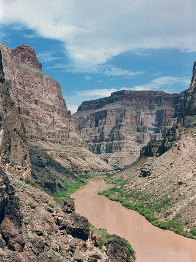
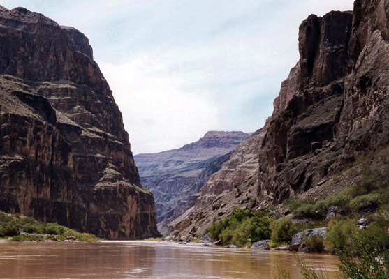
The Colorado River
The designated route mainly follows the east side of the ravine, which extends almost all the way to the Colorado. Around the river, the temperature is markedly higher than at the rim - maybe by 10°F, and the vegetation is more desert-like, with large barrel cacti and yucca. The noise of the Lava Falls rapids is audible for most of the descent; the falls themselves are reached by walking along the river banks for 200 yards. There are several small sandy beaches, good for paddling and cooling off before the return journey.
Time Required
A round trip, starting late morning on a hot, sunny August day took me 2.5 hours, or 4 hours including the extra 4 mile walk to and from the junction with the Toroweap Point Road. I had left some water at the trailhead but not taken enough for the hike, and found it best to hurry back and reach the cached supply as quickly as possible. This is certainly a hike for which a good amount of water is needed; there is none available en route as the Colorado water is unsafe to drink unless filtered. The official guide puts the round trip from the trailhead at between 4 and 12 hours.
Lava Falls Trail - Similar Hikes
All Contents © Copyright The American Southwest | Comments and Questions | Contribute | Affiliate Marketing Disclosure | Site Map