Cottonwood Lakes Trail
Path alongside a wooded creek, climbing fairly gently above the timberline, past meadows and boggy areas, to a high basin containing several beautiful lakes, directly beneath the Sierra crest. Several intersecting trails allow for different route options
Length: 5.7 miles to the furthest Cottonwood Lake (number five), or 12.8 miles for a loop additionally visiting Muir Lake
Elevation change: 1,500 feet
Difficulty: Moderate to strenuous; not too steep, but fairly long
Type: One-way, or partial loop
Usage: Medium
Season: Early summer to late fall
Trailhead: Cottonwood Lakes Campground, at the end of Horseshoe Meadows Road, or one mile back along the road
Rating (1-5): ★★★★★

The Cottonwood Lakes Trail is the main hiking path from the southernmost of the eight principal access routes into the Eastern Sierra - Horseshoe Meadows Road, which heads south from the Alabama Hills near Lone Pine, climbing 5,000 feet over 17 miles to the trailhead, beside the eponymous meadow, which lies at approximately at the divide between the southernmost, lower elevation section of the mountains where nearly all of the peaks are covered by trees, and the higher, much more extensive region further north where much of the land is above the timberline.
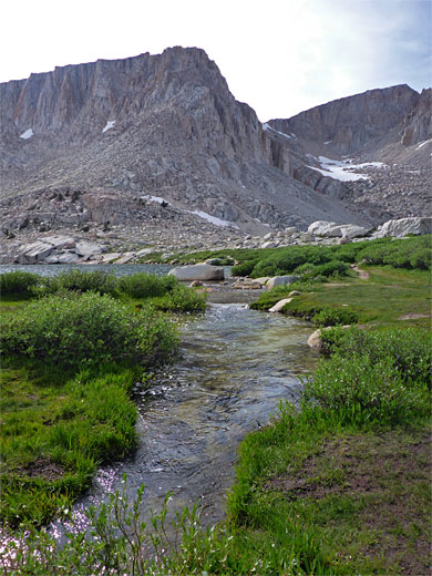
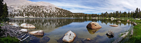
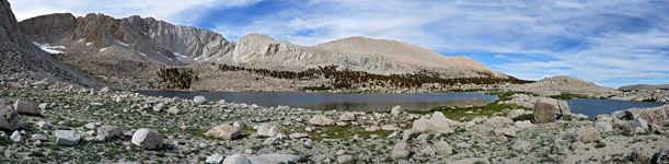
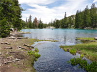
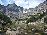
The trail also starts out through woodland, emerging after a few miles to a boulder-strewn basin containing rocky outcrops, boggy meadows and lakes - the five Cottonwood Lakes, the more isolated Muir Lake plus a number of smaller, nameless ponds. Two other paths branch off - one to the South Fork Lakes and then Cirque Lake, the other past Long Lake and High Lake to New Army Pass, continuing into Sequoia National Park, but the Cottonwood Lakes Trail is the busiest. This ends beside the uppermost pair of lakes, Four and Five, both enclosed by stark, unvegetated slopes on three sides. The rocky flats beside the lakes are a popular location for primitive camping, and a base from which to explore other areas, off-trail. High above Cottonwood Lake Four is the little-used (Old) Army Pass, reached by an extension of the path, across loose scree, which is at least partly snow-covered all year except for a short time in midsummer.
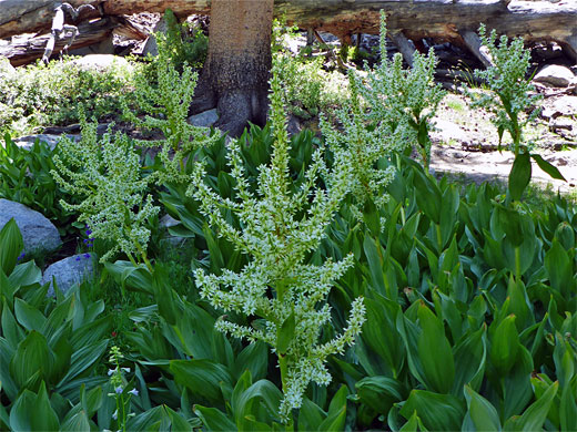
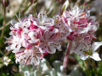
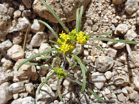
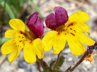
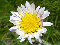
In mid to late summer wildflowers are particularly varied, reflecting the different habitats, of wet and dry woodland, streamside, meadow, tundra and talus, and the upper reaches of the trail are consistently very scenic. The shortest route to the upper lake is 5.7 miles, the elevation gain a relatively modest 1,500 feet, and several intersecting paths allow for variations, passing different areas of the basin, with partial loops in the range 11 to 14 miles. The round trip route described below, also incorporating Muir Lake, is 12.8 miles.
46 views of the Cottonwood Lakes Trail, and Horseshoe Meadows Road
Cottonwood Lakes topo map. Overview map of the Eastern Sierra
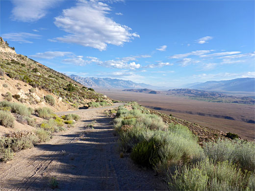
Horseshoe Meadows Road leaves Whitney Portal Road to the south, 3 miles from Lone Pine, passing a few outliers of the Alabama Hills and gradually ascending towards the Sierra foothills, soon crossing a minor gully (Carroll Creek), location of a cluster of ranch buildings, and continuing, still quite straight, up the slopes to the first bend, at 6,500 feet, followed by six gradually shorter switchbacks as the road climbs to 9,000 feet, still crossing the east-facing mountain slopes high above Owens Valley before turning west towards the high peaks, passing over a saddle and entering the valley of Little Cottonwood Creek. The road is in good condition, wide, with plenty of pull-outs and a few short parallel tracks good for camping, giving fantastic views of the valley far below and across to various mountain ranges to the east. Just before the road turns away into the valley is a promontory/overlook named Walt's Point, a popular location for hang-gliding launches.
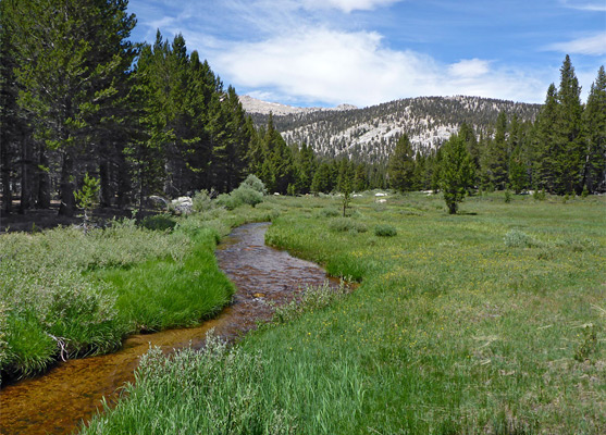
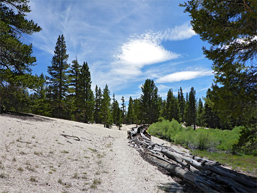
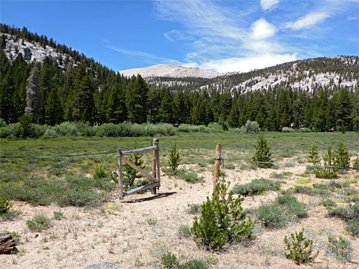
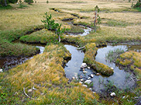
The usual start point for the hike to the Cottonwood Lakes is from the northernmost loop of the Cottonwood Lakes Campground, at road's end, though a quieter, rarely-used alternative is from a verge about one mile back, as the road makes a 90 degree bend where it crosses Cottonwood Creek; a faint path begins a little way east of the bridge, first passing through a gate and fence marking the edge of the Golden Trout Wilderness, then climbing a little, initially out-of-sight of the creek as it flows through a sequence of pools and little cascades, then leveling out after a third of a mile, soon coming close to the stream, now meandering gently through meadows and brush. The path traverses a mix of pine woodland, containing a few picturesque dead trees, moist meadows, and dry land where the short grass mingles with patches of bare white earth.
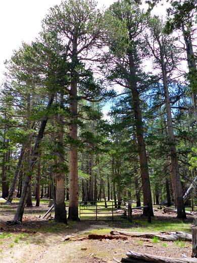
The trail, always quite narrow though easy to follow, stays on the east side of the creek, past the junction with another little-used route towards Little Cottonwood Creek, and proceeding through a larger meadow to the Golden Trout Camp, which stages educational wilderness programs. A short path connects the camp with the alternative, more well-used route, from the campground, all of which is on the west side of the creek. This trail starts by crossing a patch of nondescript forest, staying fairly level for a while then descending into the minor valley of the South Fork of Cottonwood Creek and continuing through thick woodland to the junction with the link path from the camp. About 0.8 miles back is another connecting path, fording the stream and meeting the east-side trail.
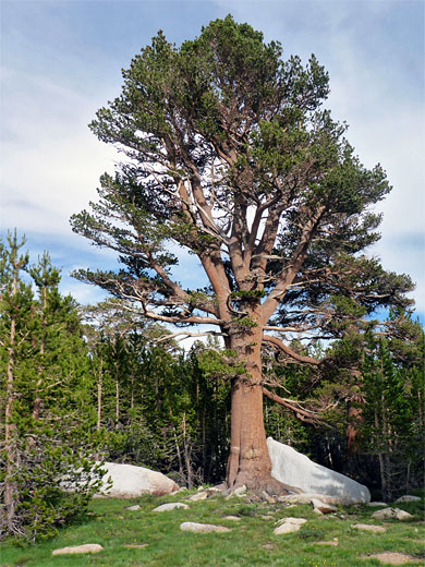
North of Golden Trout Camp, the (west) trail, which has generally stayed quite far from the creek, comes gradually closer, past a few seeps, and moves to the east side via a log bridge, just downstream of a marshy area with many orchids and other wildflowers. A sign marks the boundary of the John Muir Wilderness. The path crosses a tributary stream, then traverses drier woods of lower, more widely spaced trees, sprinkled with huge granite boulders, to another junction, signed New Army Pass left, Cottonwood Lakes right.
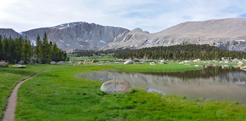
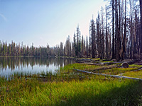
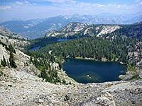
The lakes path moves away from the creek once more, ascending the slope to the north, and crossing another tiny tributary lined with many more wildflowers; a stream that originates from Hidden Lake, 700 feet away along an unofficial spur path. The main trail rises steeply once more through forest that is just a bit more enclosed and bouldery, to the rim of the Cottonwood Lakes basin, approximately at the upper edge of the treeline. The path splits again - the main lakes are left while right is a half mile spur to Muir Lake. This lake is approximately circular, bordered by cliffs to the northwest and northeast, and by sparse forest to the south. Flowers along the shoreline include alpine shooting star and alpine laurel.
A faint trail circles all around Muir Lake, crossing some pretty patches of streaked granite. There seems to be no connecting path with the main part of the basin to the west, though the cross-country route is easy, contouring round a protruding slope, across a boggy area and down to the main trail, joining it near the north end of Cottonwood Lake Three, in the vicinity of another intersection - to the south, one of the paths follows the east edge of the lake before linking with the New Army Pass Trail, while the other is the trail from the junction south of Muir Lake; from this junction, the path crosses wet grassland and a drier meadow then runs alongside a shallow lake, another of the Cottonwood Lakes though not seemingly bestowed with a number.
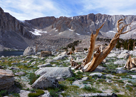
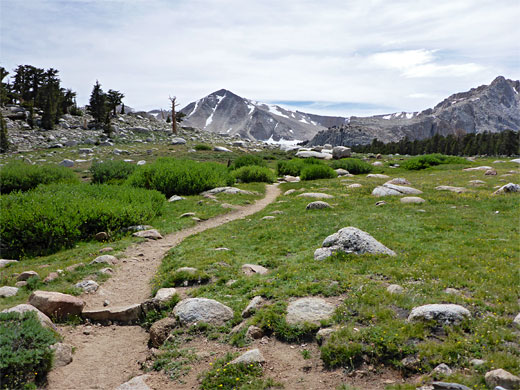
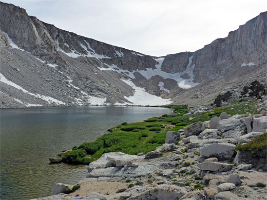
From the north end of Cottonwood Lake Three, the path ascends a rocky slope, moves close to the entry stream and follows this a short distance to the next lake, Four, which is separated from the uppermost, Five, by a narrow divide. These two lakes are set in cirques right beneath the Sierra crest, which rises up to 1,400 feet higher. The slopes are entirely bare rock, without any grass or bushes, and retain some snow all year. A few stark dead trees mingle with the light grey boulders strewn all around. A path leads all around lake five and another goes about half way round lake four, continuing up to Army Pass after crossing a sizeable slope of loose scree.
The trail also starts out through woodland, emerging after a few miles to a boulder-strewn basin containing rocky outcrops, boggy meadows and lakes - the five Cottonwood Lakes, the more isolated Muir Lake plus a number of smaller, nameless ponds. Two other paths branch off - one to the South Fork Lakes and then Cirque Lake, the other past Long Lake and High Lake to New Army Pass, continuing into Sequoia National Park, but the Cottonwood Lakes Trail is the busiest. This ends beside the uppermost pair of lakes, Four and Five, both enclosed by stark, unvegetated slopes on three sides. The rocky flats beside the lakes are a popular location for primitive camping, and a base from which to explore other areas, off-trail. High above Cottonwood Lake Four is the little-used (Old) Army Pass, reached by an extension of the path, across loose scree, which is at least partly snow-covered all year except for a short time in midsummer.
In mid to late summer wildflowers are particularly varied, reflecting the different habitats, of wet and dry woodland, streamside, meadow, tundra and talus, and the upper reaches of the trail are consistently very scenic. The shortest route to the upper lake is 5.7 miles, the elevation gain a relatively modest 1,500 feet, and several intersecting paths allow for variations, passing different areas of the basin, with partial loops in the range 11 to 14 miles. The round trip route described below, also incorporating Muir Lake, is 12.8 miles.
Photographs
46 views of the Cottonwood Lakes Trail, and Horseshoe Meadows Road
Maps
Cottonwood Lakes topo map. Overview map of the Eastern Sierra
Horseshoe Meadows Road
Horseshoe Meadows Road leaves Whitney Portal Road to the south, 3 miles from Lone Pine, passing a few outliers of the Alabama Hills and gradually ascending towards the Sierra foothills, soon crossing a minor gully (Carroll Creek), location of a cluster of ranch buildings, and continuing, still quite straight, up the slopes to the first bend, at 6,500 feet, followed by six gradually shorter switchbacks as the road climbs to 9,000 feet, still crossing the east-facing mountain slopes high above Owens Valley before turning west towards the high peaks, passing over a saddle and entering the valley of Little Cottonwood Creek. The road is in good condition, wide, with plenty of pull-outs and a few short parallel tracks good for camping, giving fantastic views of the valley far below and across to various mountain ranges to the east. Just before the road turns away into the valley is a promontory/overlook named Walt's Point, a popular location for hang-gliding launches.
Golden Trout Wilderness
The usual start point for the hike to the Cottonwood Lakes is from the northernmost loop of the Cottonwood Lakes Campground, at road's end, though a quieter, rarely-used alternative is from a verge about one mile back, as the road makes a 90 degree bend where it crosses Cottonwood Creek; a faint path begins a little way east of the bridge, first passing through a gate and fence marking the edge of the Golden Trout Wilderness, then climbing a little, initially out-of-sight of the creek as it flows through a sequence of pools and little cascades, then leveling out after a third of a mile, soon coming close to the stream, now meandering gently through meadows and brush. The path traverses a mix of pine woodland, containing a few picturesque dead trees, moist meadows, and dry land where the short grass mingles with patches of bare white earth.
Golden Trout Camp
The trail, always quite narrow though easy to follow, stays on the east side of the creek, past the junction with another little-used route towards Little Cottonwood Creek, and proceeding through a larger meadow to the Golden Trout Camp, which stages educational wilderness programs. A short path connects the camp with the alternative, more well-used route, from the campground, all of which is on the west side of the creek. This trail starts by crossing a patch of nondescript forest, staying fairly level for a while then descending into the minor valley of the South Fork of Cottonwood Creek and continuing through thick woodland to the junction with the link path from the camp. About 0.8 miles back is another connecting path, fording the stream and meeting the east-side trail.
John Muir Wilderness
North of Golden Trout Camp, the (west) trail, which has generally stayed quite far from the creek, comes gradually closer, past a few seeps, and moves to the east side via a log bridge, just downstream of a marshy area with many orchids and other wildflowers. A sign marks the boundary of the John Muir Wilderness. The path crosses a tributary stream, then traverses drier woods of lower, more widely spaced trees, sprinkled with huge granite boulders, to another junction, signed New Army Pass left, Cottonwood Lakes right.
Muir Lake
The lakes path moves away from the creek once more, ascending the slope to the north, and crossing another tiny tributary lined with many more wildflowers; a stream that originates from Hidden Lake, 700 feet away along an unofficial spur path. The main trail rises steeply once more through forest that is just a bit more enclosed and bouldery, to the rim of the Cottonwood Lakes basin, approximately at the upper edge of the treeline. The path splits again - the main lakes are left while right is a half mile spur to Muir Lake. This lake is approximately circular, bordered by cliffs to the northwest and northeast, and by sparse forest to the south. Flowers along the shoreline include alpine shooting star and alpine laurel.
Cottonwood Lakes Basin
A faint trail circles all around Muir Lake, crossing some pretty patches of streaked granite. There seems to be no connecting path with the main part of the basin to the west, though the cross-country route is easy, contouring round a protruding slope, across a boggy area and down to the main trail, joining it near the north end of Cottonwood Lake Three, in the vicinity of another intersection - to the south, one of the paths follows the east edge of the lake before linking with the New Army Pass Trail, while the other is the trail from the junction south of Muir Lake; from this junction, the path crosses wet grassland and a drier meadow then runs alongside a shallow lake, another of the Cottonwood Lakes though not seemingly bestowed with a number.
The Uppermost Lakes
From the north end of Cottonwood Lake Three, the path ascends a rocky slope, moves close to the entry stream and follows this a short distance to the next lake, Four, which is separated from the uppermost, Five, by a narrow divide. These two lakes are set in cirques right beneath the Sierra crest, which rises up to 1,400 feet higher. The slopes are entirely bare rock, without any grass or bushes, and retain some snow all year. A few stark dead trees mingle with the light grey boulders strewn all around. A path leads all around lake five and another goes about half way round lake four, continuing up to Army Pass after crossing a sizeable slope of loose scree.
Cottonwood Lakes Trail - Similar Hikes
All Contents © Copyright The American Southwest | Comments and Questions | Contribute | Affiliate Marketing Disclosure | Site Map