Monarch Canyon, Death Valley National Park
California > Death Valley National Park > The East > Monarch Canyon

Monarch Canyon
Rocky ravine through the Funeral Mountains, containing a spring, a stream and a multi-stage, 110 foot waterfall, which can be bypassed by a steep climb. The canyon may be explored from the upper or lower ends
Length: 3 miles from Beatty Cutoff Road to the base of the falls; 3.5 miles to the spring. The upper approach is 1.5 miles to the top of the falls
Elevation change: 1,000 feet, from the road to the spring (650 feet to the base of the falls)
Difficulty: Easy to the falls; strenuous if following the bypass route to the upper canyon
Type: One way
Usage: Low
Season: Fall, winter, spring
Trailhead: Beatty Cutoff Road, 0.8 miles south of Hells Gate
Rating (1-5): ★★★★★

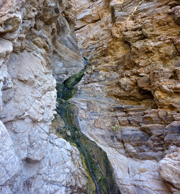
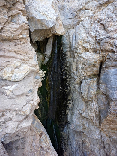
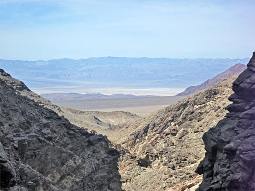
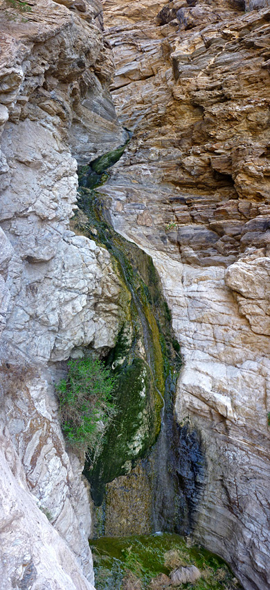
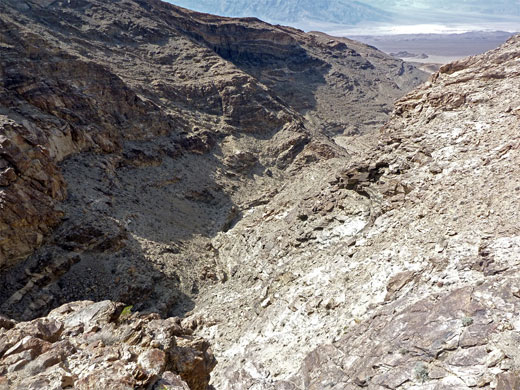
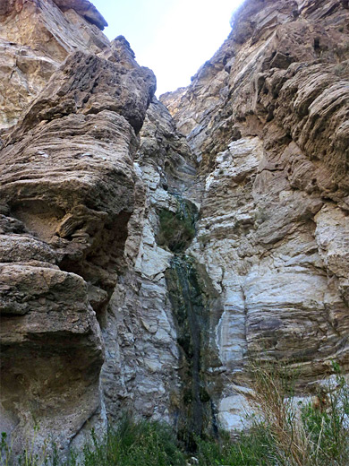
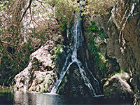
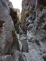
Monarch Canyon is one of the few drainages either side of Death Valley to contain a permanent spring; only a small water source, but enough to sustain a few hundred feet of shallow stream and, at most times of year, an impressive, multistage waterfall, where the creek tumbles 110 feet down a cliff face, partially enclosed within a very short, twisting slot. Above here, the canyon is quite overgrown for a while and soon becomes shallow, while below the cliffs also open out after a short distance, to a dry gorge bordered by typical weathered, fractured rocks in a range of muted colors. This is also fairly short, ending at the edge of a vast alluvial fan that slopes gently down towards the main valley floor.
The falls can be passed from above by rappelling, or avoided by a rather steep scramble up-and-down the rocky slopes to the north, but most of the relatively few people who visit see only the upper or lower parts of the canyon, as far as the top or base of the waterfall. The lower end of the drainage is reached by an easy, 1.5 mile walk over the alluvial fan, starting from Beatty Cutoff Road, while the upper section starts beside a backcountry track, 2.8 miles from Daylight Pass Road. This is the most popular approach since less hiking is involved, and the upstream section of the canyon also contains a few mine relics, but the view of the falls is best from below, and this approach is recommended for drivers of 2WD, low clearance vehicles.
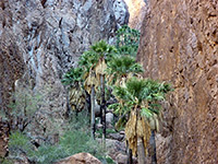
Apart from the waterfall, which is somewhat enclosed and difficult to photograph effectively, there isn't too much of interest in Monarch Canyon, just the usual array of desert plants and eroded metamorphic rocks. The ravine is part of the Funeral Mountains, on the east side of Death Valley, which here are relatively low compared to other nearby ranges, rising up to 2,000 feet above the flat lands at either side.
Map of Death Valley National Park and surroundings.
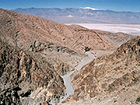
Some maps show a trail to the lower end of Monarch Canyon but there is no obvious sign today, however the gorge is easily reached by walking cross country, starting from the closest approach of Beatty Cutoff Road, about 0.8 miles south of Hells Gate junction. The verges are wide, so there are plenty of parking places. The relatively high elevation (1,700 feet) affords excellent views across Death Valley towards the Mesquite Dunes, ten miles southwest. The unpaved road to the upper end of the canyon leaves Daylight Pass Road 3 miles south of the NV/CA stateline, and reaches a junction after 2.2 miles with a short spur to a parking area beside the drainage, as the ravine starts to deepen. The track continues to the site of Chloride City, an extensive gold mining district, before leaving the mountains and crossing desert plains to the east, in Nevada.
The following description relates to the southern approach. The mouth of Monarch Canyon is quite evident from Beatty Cutoff Road, being the biggest ravine through this section of the mountains. The cross-country hiking route is due east, nearly perpendicular to the road, and is level for the first mile or so, over a typical gravelly fan, which is cut by many shallow boulder-filled channels, all the while aiming for the right side of some pinkish mounds, where the wide exit streamway is first encountered. Walking upstream, the land begins to slope upwards but only gently. Two tributaries join, one on each side, but there is no mistaking the main drainage. The surrounding rocks are colored many subdued shades of brown, grey and red, plus white, and all are angled, twisted, aged and weathered, with only a light covering of vegetation, including large barrel cacti.
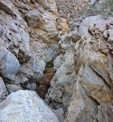
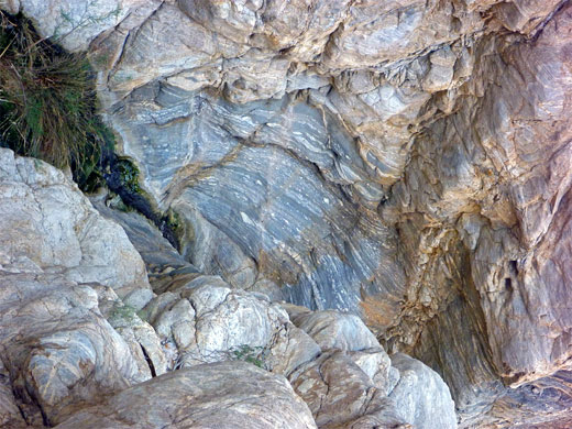
After several wide bends, a few big boulders start to appear in the otherwise pebbly streambed, plus one huge chokestone above a short dryfall, but there is little of note until the waterfall. The ground is moist for a few hundred feet below, leading to a stretch of flowing water, a brief overgrown area around the base, and a shallow, mossy pool. The falls are not a single, sheer drop, rather a very steep, several stage cascade flowing down a smooth, near vertical chute. The rocks around the streamway are grey in color, partly composed of travertine, and water-polished. Only the lowest part of the falls is properly visible from below, though most of the upper section can be seen by climbing a little away up the left side.
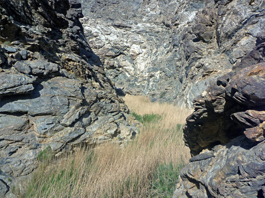
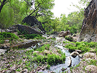
Above this viewpoint, the cliffs are sheer, however a steep, boulder-filled hillside to the north provides a bypass route - up about 350 feet over rocky, cactus-studded terrain to the base of a narrow, north-south escarpment, into a little ravine, over the top of the ridge and down the shorter, less steep slope on the far side, rejoining the streamway above the falls and about 500 feet north of the drop. This section of Monarch Canyon is filled with reeds and long grass for a little way upstream, past Monarch Spring, but is more open downstream. The creek trickles gently through the undergrowth, yet the drainage is not too appealing; muddy and boggy, with brown algae and just a few shallow pools, since the stream flows mostly over earth rather than bare rock. There are no narrows downstream, instead the falls begin abruptly and are mostly out-of-sight, hidden by boulders and the overhanging cliffs below. Upstream, a faint path winds past the thickest part of the reeds, then fades away as the canyon becomes dry, open and shallow, and the lower end of the upper approach road is about two thirds of a mile beyond.
The falls can be passed from above by rappelling, or avoided by a rather steep scramble up-and-down the rocky slopes to the north, but most of the relatively few people who visit see only the upper or lower parts of the canyon, as far as the top or base of the waterfall. The lower end of the drainage is reached by an easy, 1.5 mile walk over the alluvial fan, starting from Beatty Cutoff Road, while the upper section starts beside a backcountry track, 2.8 miles from Daylight Pass Road. This is the most popular approach since less hiking is involved, and the upstream section of the canyon also contains a few mine relics, but the view of the falls is best from below, and this approach is recommended for drivers of 2WD, low clearance vehicles.
Apart from the waterfall, which is somewhat enclosed and difficult to photograph effectively, there isn't too much of interest in Monarch Canyon, just the usual array of desert plants and eroded metamorphic rocks. The ravine is part of the Funeral Mountains, on the east side of Death Valley, which here are relatively low compared to other nearby ranges, rising up to 2,000 feet above the flat lands at either side.
Location
Map of Death Valley National Park and surroundings.
Approach
Some maps show a trail to the lower end of Monarch Canyon but there is no obvious sign today, however the gorge is easily reached by walking cross country, starting from the closest approach of Beatty Cutoff Road, about 0.8 miles south of Hells Gate junction. The verges are wide, so there are plenty of parking places. The relatively high elevation (1,700 feet) affords excellent views across Death Valley towards the Mesquite Dunes, ten miles southwest. The unpaved road to the upper end of the canyon leaves Daylight Pass Road 3 miles south of the NV/CA stateline, and reaches a junction after 2.2 miles with a short spur to a parking area beside the drainage, as the ravine starts to deepen. The track continues to the site of Chloride City, an extensive gold mining district, before leaving the mountains and crossing desert plains to the east, in Nevada.
The Lower Canyon
The following description relates to the southern approach. The mouth of Monarch Canyon is quite evident from Beatty Cutoff Road, being the biggest ravine through this section of the mountains. The cross-country hiking route is due east, nearly perpendicular to the road, and is level for the first mile or so, over a typical gravelly fan, which is cut by many shallow boulder-filled channels, all the while aiming for the right side of some pinkish mounds, where the wide exit streamway is first encountered. Walking upstream, the land begins to slope upwards but only gently. Two tributaries join, one on each side, but there is no mistaking the main drainage. The surrounding rocks are colored many subdued shades of brown, grey and red, plus white, and all are angled, twisted, aged and weathered, with only a light covering of vegetation, including large barrel cacti.
The Falls
After several wide bends, a few big boulders start to appear in the otherwise pebbly streambed, plus one huge chokestone above a short dryfall, but there is little of note until the waterfall. The ground is moist for a few hundred feet below, leading to a stretch of flowing water, a brief overgrown area around the base, and a shallow, mossy pool. The falls are not a single, sheer drop, rather a very steep, several stage cascade flowing down a smooth, near vertical chute. The rocks around the streamway are grey in color, partly composed of travertine, and water-polished. Only the lowest part of the falls is properly visible from below, though most of the upper section can be seen by climbing a little away up the left side.
Upper Monarch Canyon
Above this viewpoint, the cliffs are sheer, however a steep, boulder-filled hillside to the north provides a bypass route - up about 350 feet over rocky, cactus-studded terrain to the base of a narrow, north-south escarpment, into a little ravine, over the top of the ridge and down the shorter, less steep slope on the far side, rejoining the streamway above the falls and about 500 feet north of the drop. This section of Monarch Canyon is filled with reeds and long grass for a little way upstream, past Monarch Spring, but is more open downstream. The creek trickles gently through the undergrowth, yet the drainage is not too appealing; muddy and boggy, with brown algae and just a few shallow pools, since the stream flows mostly over earth rather than bare rock. There are no narrows downstream, instead the falls begin abruptly and are mostly out-of-sight, hidden by boulders and the overhanging cliffs below. Upstream, a faint path winds past the thickest part of the reeds, then fades away as the canyon becomes dry, open and shallow, and the lower end of the upper approach road is about two thirds of a mile beyond.
Monarch Canyon - Similar Hikes
All Contents © Copyright The American Southwest | Comments and Questions | Contribute | Affiliate Marketing Disclosure | Site Map