Darwin Canyon, Death Valley National Park
California > Death Valley National Park > The West > Darwin Canyon

Darwin Canyon
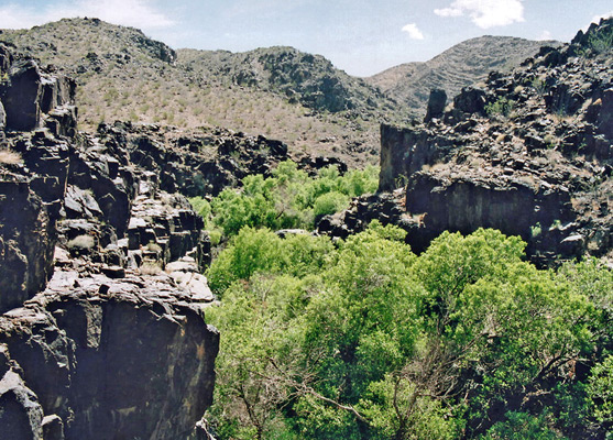
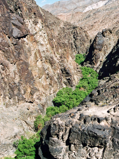
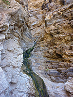
Darwin Canyon contains one of the highest waterfalls in the national park (80 feet), plus smaller falls and cascades, deep pools and a permanent stream running through a narrow, boulder-filled gorge, all fed by springs high up the ravine; reached by a maintained trail to the base then by lesser paths upstream
Length: 1.5 miles, to the canyon above the waterfalls
Elevation change: 500 feet
Difficulty: Easy to the base of the falls; moderate beyond
Type: One way
Usage: Medium
Season: Fall, winter, spring
Location: 2 miles along a gravel track, off Hwy 190
Rating (1-5): ★★★★★
Elevation change: 500 feet
Difficulty: Easy to the base of the falls; moderate beyond
Type: One way
Usage: Medium
Season: Fall, winter, spring
Location: 2 miles along a gravel track, off Hwy 190
Rating (1-5): ★★★★★

West of the main Death Valley, the national park includes most of Panamint Valley, similarly stark and empty, though not so extreme in elevation; highway CA 190, which crosses towards the north end, has a low point of 1,540 feet. Panamint has many steep side ravines including Darwin Canyon, which contains the highest waterfall in the national park (80 feet), plus smaller falls and cascades, deep pools and a permanent stream running through a narrow, boulder-filled gorge, all fed by springs high up in the canyon.
The falls are easily reached by a maintained trail to the base then by lesser paths that continue upstream.
Darwin Falls Trail topographic map.
6 views of Darwin Canyon.
The Darwin Falls trailhead is accessed by a 2 mile gravel track, bumpy but wide and fine for all vehicles, starting from CA 190, one mile west of Panamint Springs - a small settlement that provides the only visitor facilities for some distance including a gas station, campsite and lodging. Panamint Springs is 30 miles from Stovepipe Wells in the middle of Death Valley, and the approach from the east is quite spectacular, as the road descends 3,500 feet starting from a high point at Towne Pass, down a twisty canyon then becomes dead straight for several miles as it crosses the sand flats on the valley floor. The approach road from the west is also rather dramatic, encountering tight switchbacks and steep sections as it traverses rocky slopes above a deep side valley (Rainbow Canyon). The turning to Darwin Falls is not signposted from the highway but the track does have an NPS sign a little way along. It crosses the wash (usually dry, since the waters that flow further upstream sink below ground shortly after the last waterfall), follows along the left side of the canyon then, just before a sign announcing '4WD only', has a turn off on the right to a small parking area for the trailhead. The track continues, rough in places, to an alternative access point to the canyon a few miles above the waterfalls, though most people just explore from the lower end.
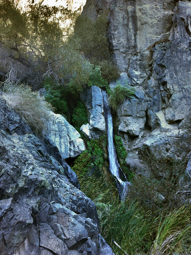
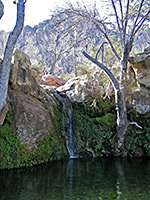
From the parking area, the well trodden path to the falls crosses the dry wash and follows close to the right side of the valley, running alongside a plastic supply pipe that takes water from the creek, presumably to Panamint Springs village. The path passes through two iron fences, the second shortly before the canyon narrows, a stream starts to flow, and the canyon floor becomes quite overgrown. The route is now on the left side, close to the cliffs, and the path is dark and cool, shaded by big cottonwood trees. It ends at the foot of the lower falls, where the waters pour about 20 feet onto a boulder and split into 2 channels, which flow into a shallow pool beneath - an oft photographed scene. The pool is ringed by ferns and bushes and is a peaceful spot if visited alone, though the hike to this point tends to be quite popular. Most people go no further, however.
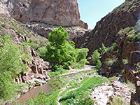
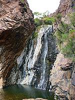
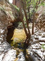
An easy climb quite high up the hillside on the left of the canyon leads to a viewpoint of the three main falls, the top one being 80 feet high - quite a narrow stream of water falling down a chute into a pile of boulders within a short slot section. A little way back down is a route to the base of the second falls, then opposite, on the north side of the canyon, is a steep slope of rather loose rocks that provides a route further up, above all three falls, and then, following a faint path across flatter land, back down to the creek, directly above the upper falls. The canyon is now rather different in character, with fewer trees, more boulders and less undergrowth. The ravine is somewhat shallower and the creek flows through many small cascades, watery channels and pools, all easily passed by hiking along benches at either side. There are various cacti in the upper canyon, unlike in the barren lower gorge. The creek has no more large falls, and the sides soon become less steep, allowing for climbs to the mesa top.
The falls are easily reached by a maintained trail to the base then by lesser paths that continue upstream.
Map
Darwin Falls Trail topographic map.
Photographs
6 views of Darwin Canyon.
Approaches to Darwin Canyon
The Darwin Falls trailhead is accessed by a 2 mile gravel track, bumpy but wide and fine for all vehicles, starting from CA 190, one mile west of Panamint Springs - a small settlement that provides the only visitor facilities for some distance including a gas station, campsite and lodging. Panamint Springs is 30 miles from Stovepipe Wells in the middle of Death Valley, and the approach from the east is quite spectacular, as the road descends 3,500 feet starting from a high point at Towne Pass, down a twisty canyon then becomes dead straight for several miles as it crosses the sand flats on the valley floor. The approach road from the west is also rather dramatic, encountering tight switchbacks and steep sections as it traverses rocky slopes above a deep side valley (Rainbow Canyon). The turning to Darwin Falls is not signposted from the highway but the track does have an NPS sign a little way along. It crosses the wash (usually dry, since the waters that flow further upstream sink below ground shortly after the last waterfall), follows along the left side of the canyon then, just before a sign announcing '4WD only', has a turn off on the right to a small parking area for the trailhead. The track continues, rough in places, to an alternative access point to the canyon a few miles above the waterfalls, though most people just explore from the lower end.
The Hike
From the parking area, the well trodden path to the falls crosses the dry wash and follows close to the right side of the valley, running alongside a plastic supply pipe that takes water from the creek, presumably to Panamint Springs village. The path passes through two iron fences, the second shortly before the canyon narrows, a stream starts to flow, and the canyon floor becomes quite overgrown. The route is now on the left side, close to the cliffs, and the path is dark and cool, shaded by big cottonwood trees. It ends at the foot of the lower falls, where the waters pour about 20 feet onto a boulder and split into 2 channels, which flow into a shallow pool beneath - an oft photographed scene. The pool is ringed by ferns and bushes and is a peaceful spot if visited alone, though the hike to this point tends to be quite popular. Most people go no further, however.
The Upper Falls
An easy climb quite high up the hillside on the left of the canyon leads to a viewpoint of the three main falls, the top one being 80 feet high - quite a narrow stream of water falling down a chute into a pile of boulders within a short slot section. A little way back down is a route to the base of the second falls, then opposite, on the north side of the canyon, is a steep slope of rather loose rocks that provides a route further up, above all three falls, and then, following a faint path across flatter land, back down to the creek, directly above the upper falls. The canyon is now rather different in character, with fewer trees, more boulders and less undergrowth. The ravine is somewhat shallower and the creek flows through many small cascades, watery channels and pools, all easily passed by hiking along benches at either side. There are various cacti in the upper canyon, unlike in the barren lower gorge. The creek has no more large falls, and the sides soon become less steep, allowing for climbs to the mesa top.
Darwin Canyon - Similar Hikes
All Contents © Copyright The American Southwest | Comments and Questions | Contribute | Affiliate Marketing Disclosure | Site Map