Highlights:
Nearby town:
San Diego (Bayside area), 5 miles
Management:
Location:
Seasons:
All year. Whale watching is best around mid winter and late summer. Opening hours are 9 am to 5 pm
Rating (1-5):
★★★★★
Weather:


Cabrillo NM is part of the California South Coast itinerary
Featured Hotel
Holiday Inn San Diego-Bayside
 One of the closest hotels to Cabrillo National Monument, 5 miles north along Hwy 209. Includes an onsite restaurant, outdoor pool and putting green
Check Rates
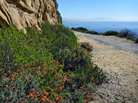
Great views of the Pacific Ocean and San Diego Bay, wildflower-covered hillsides, whale watching, an historic lighthouse and tidepools along a rocky coastline are the attractions of Cabrillo National Monument, which covers a small area of less than one square mile near the southern end of Point Loma, a narrow spur of land over 400 feet in elevation, jutting out into the Pacific Ocean. The monument is relatively little known compared to the large national parks of California but its city location ensures a steady stream of visitors all year.
The site was first protected in 1932 as a California Historical Landmark, and upgraded to a national monument in 1949. In addition to the overlooks, historic features and short paths on top of the peninsula are two longer trails, one (Coastal Trail) to a series of tidepools and eroded cliffs on the ocean side of the peninsula, the other (Bayside Trail) through coastal scrub to an overlook of San Diego.
The national monument is reached by Catalina Boulevard through Point Loma, and then Cabrillo Memorial Drive, leading to a large parking lot in front of the visitor center. A short side road descends to the rocky shoreline to the west. The park is open from 9 am to 5 pm, every day of the year, and the entrance fee (2024) is $20 per vehicle.
Cabrillo Table of Contents
- Map of the national monument
- Photographs
- Tours of San Diego
- History - Juan Rodriguez Cabrillo
- Scenery of Cabrillo NM
- The Cabrillo coastline
- Hiking; Bayside Trail and Coastal Trail
- Wildflowers of Cabrillo National Monument
- Nearby places
- Similar places
Map of Cabrillo National Monument
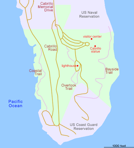
Detail map
Photographs
38 views of Cabrillo National Monument.
San Diego Tours
Whale watching, and cruising!
History - Juan Rodriguez Cabrillo
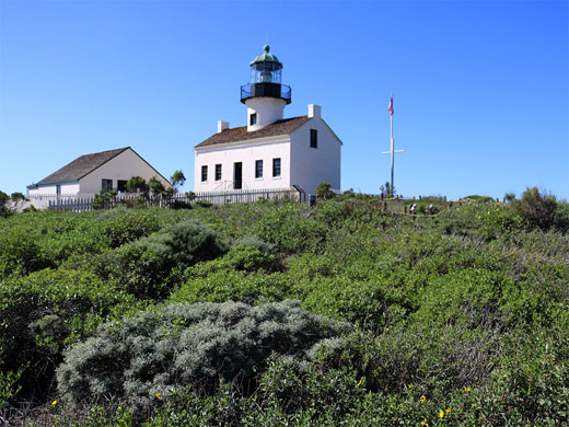
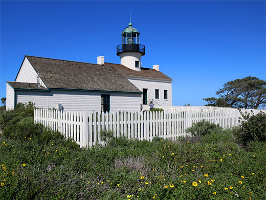
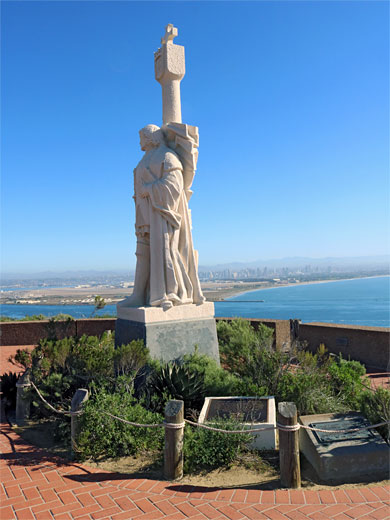
The monument commemorates and is named after Juan Rodriguez Cabrillo, the first European to explore the western coast of the USA - sailing north from Mexico, Juan entered what is now San Diego Bay in September 1542, and rested there for a while before the expedition proceeded up the California coast, possibly as far as Oregon. The small part of the Point Loma peninsula occupied by the Cabrillo National Monument is 9 miles from San Diego city center via CA 209 and is bordered by a US Naval Reservation to the north (which contains the Fort Rosencrantz National Cemetery), and a Coast Guard Reservation to the south; the peninsula has been occupied by the military since 1852 owing to its strategically important position. The centerpiece is the whitewashed building housing the Old Point Loma Lighthouse, built in 1855 but in service for only 36 years since its light was too often obscured by fog; a new station was built nearer sea level and proved to be more effective. The interior has been preserved with all original fixtures and fittings dating from the late nineteenth century, while other exhibits can be seen in an adjacent museum, in what was once the assistant keeper's house.
Scenery of Cabrillo NM
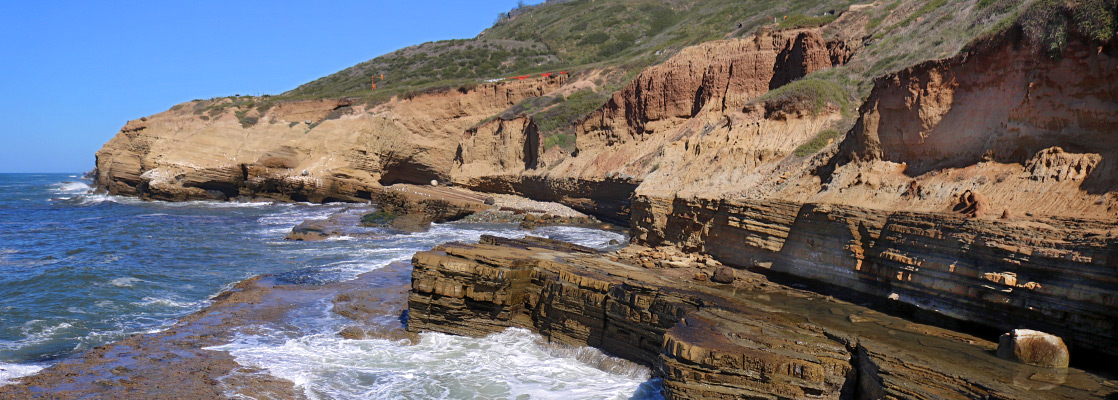
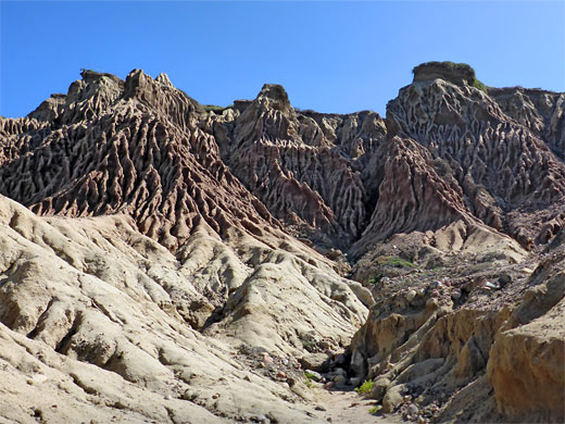
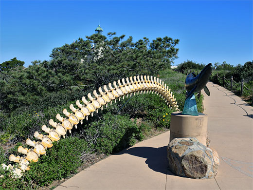
The peninsula is a sedimentary outcrop rising to 422 feet above sea level. Most rocks are from the Cabrillo Formation, sandstone and conglomerate, while the lower slopes are from the Bay Point Formation, in turn overlying the Point Loma Formation, sandstone and shale, in which are found the tidepools along the western shoreline. Meadows, bushes and trees cover the flat land on top, and the steep hillsides, which are enlivened by many species of wildflowers in spring and summer. Three unusual desert plants, found in very few other places in the country, are coastal agave, San Diego barrel cactus and golden cereus. Short paths link the visitor center, the old lighthouse, a statue of Juan Cabrillo (installed in 1988, replacing an earlier version that had become weathered) and several viewpoints, while the longer (1.2 mile) Bayside Trail descends through the shrubbery on the bay side, ending at an overlook, although this seems not to be very popular. Around the center are various displays relating to the natural history of San Diego Bay and the military hardware located at the US Naval Air Station clearly visible just across the waters on North Island; beyond here are the skyscrapers of downtown San Diego and the mountains in the Cleveland National Forest looming in the distance. Another path, south of the lighthouse, goes to Whale Overlook, a good place to look for cetaceans in the ocean below; along the way are a whale sculpture, and a replica whale backbone.
The Cabrillo Coastline
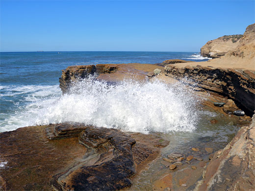
On all sides of the Cabrillo peninsula the hills drop down to rocky cliffs with exposed, angled strata, and sandy bluffs eroded by wind and rain into unusual, small-scale formations. The coast on the west side is accessible by road, from where a half mile footpath, the Coastal Trail, also known as the Point Loma Tidepools Trail, runs just above the sea, passing several places to climb down to the pools, wave-cut terraces, mini caves and pebble beaches along the water's edge. This part of the Pacific lies in the migration path of grey whales, who journey to Baja California and the Arctic Ocean around October and return during January-February. The sea on the east side of the peninsula is not accessible.
Trails of Cabrillo National Monument
Bayside Trail
★★★★★
★★★★★
1.2 miles, 280 feet
Traverse of the bluffs on the east side of the peninsula, rich in plant life; ending at a fine viewpoint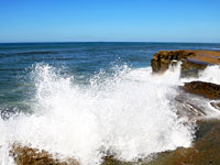
Coastal Trail
★★★★★
★★★★★
0.5 miles, 80 feet
Popular path across sandstone terraces on the Pacific side of the peninsula, past cliffs, bluffs and tidepoolsCabrillo Wildflowers
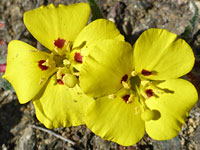
Photographs and descriptions of flowering plants found in the national monument
Cabrillo - Nearby Places
- La Jolla Tide Pools (15 miles) - wave-carved pools, sea caves, terraces and other rock formations
- Torrey Pines State Reserve (18 miles) - dunes, beaches, wildflower-covered hillsides and eroded sandstone cliffs
Cabrillo - Similar Places
- Salt Point State Park - scenic Pacific Ocean cliffs in Sonoma County
- Torrey Pines State Reserve - dunes and eroded sandstone cliffs north of San Diego
All Contents © Copyright The American Southwest | Comments and Questions | Contribute | Affiliate Marketing Disclosure | Site Map