Bayside Trail
Traverse of the wildflower-rich bluffs on the east side of Point Loma Peninsula, in and out of two ravines, past two historic structures, ending at a fine viewpoint of San Diego Bay
Length: 1.2 miles
Elevation change: 280 feet
Difficulty: Easy
Type: One way
Usage: High
Season: All year
Trailhead: The main parking area, by the visitor center
Rating (1-5): ★★★★★
Elevation change: 280 feet
Difficulty: Easy
Type: One way
Usage: High
Season: All year
Trailhead: The main parking area, by the visitor center
Rating (1-5): ★★★★★

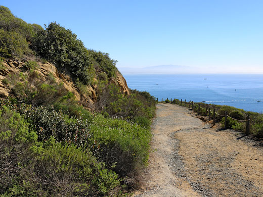
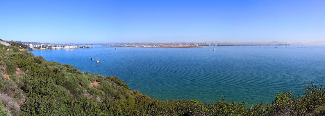
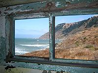
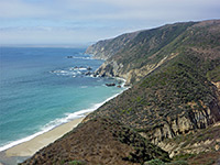
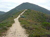
The only two footpaths in Cabrillo National Monument are the Coastal Trail to the tidepools on the west side of Point Loma Peninsula, and, to the east, the Bayside Trail, which descends gradually down bushy, sandstone slopes, in and out of two ravines, ending at a viewpoint of San Diego and the bay, about 80 feet above the water level - the land is too steep to reach the sea itself.
The actual trail is 0.8 miles, descending 230 feet, though this is accessed by walking along a service road, closed to public vehicles, so the total distance of the hike is 1.2 miles, starting from the main parking lot beside the visitor center.
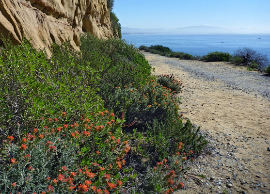
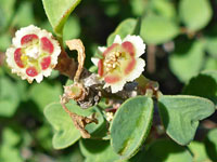
Besides the excellent views, the hike is also notable for the variety of flowering plants, with maybe 50 different types growing here, representative of the endangered coastal scrub habitat, including at least two very rare species, coastal agave and cliff spurge.
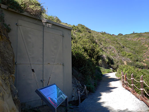
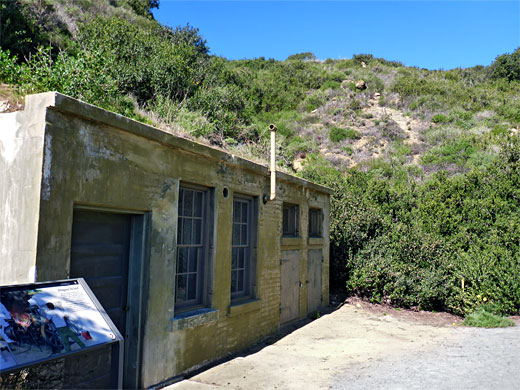
Also of interest are two abandoned structures built in 1919 - a shelter housing a searchlight, and a power building to supply electricity. The trail follows what was Sylvester Road, serving the searchlight and other military emplacements; this originally continued northwards into Fort Rosencrans, but the section outside the national monument is now closed.
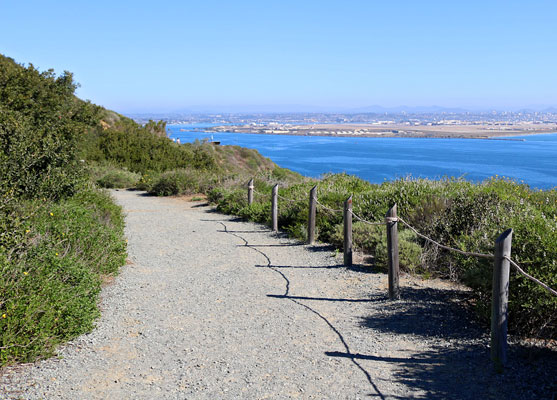
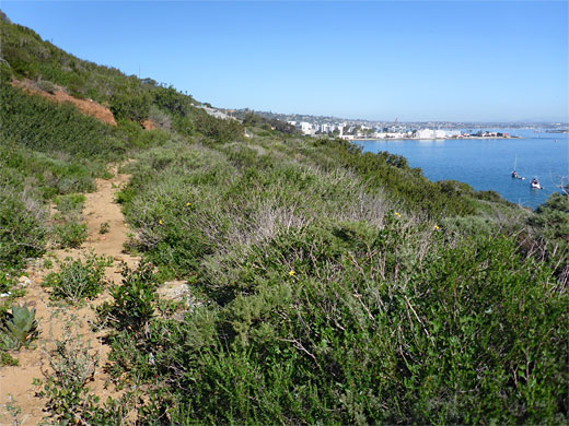
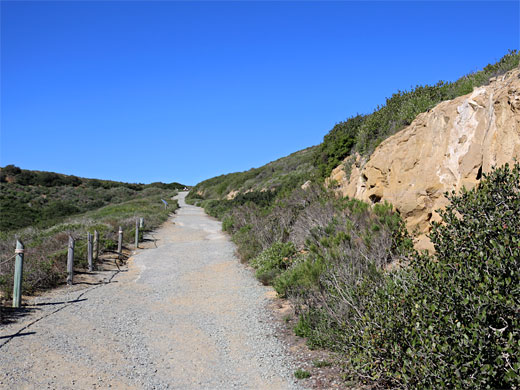
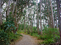
From the parking area, the start of the Bayside Trail is accessed by walking south along a paved road (Humphrey Road, leading to a radar installation), past Point Loma Lighthouse, down a slope and around the head of a broad ravine, where the path branches off - a straight, wide gravel track, heading down the ravine towards the ocean, beneath low, sandy cliffs bearing many wildflowers in the spring. It curves round a slope and cuts back inland to a second ravine, past the abandoned searchlight shelter, with a short section of rail line in front, then on to the power plant at the upper end of the drainage. The next quarter of a mile is similar, round a broad point, in and out of a third ravine, all the while gradually descending, ending with a longer straightish section to the final viewpoint, at which are a bench and a notice about the Point Loma Ecological Reserve. On clear, sunny days, the panorama extends across the Laguna Mountains beyond San Diego, and to more distant ranges in Mexico.
A need for additional coastal defences around San Diego was identified following a review after World War I, and part of the plan called for installation of eight searchlights on the Point Loma Peninsula. One, number five, was built near the southeast end of the peninsula, along what is now the Bayside Trail. The power plant was situated in a sheltered location in a little ravine, providing electricity for the light which could be moved from its concrete and metal cabin along a short rail line, curving to the south. The plant also powered searchlight number six, a little way west and 60 feet above. All searchlights were removed soon after the Second War.
The actual trail is 0.8 miles, descending 230 feet, though this is accessed by walking along a service road, closed to public vehicles, so the total distance of the hike is 1.2 miles, starting from the main parking lot beside the visitor center.
Besides the excellent views, the hike is also notable for the variety of flowering plants, with maybe 50 different types growing here, representative of the endangered coastal scrub habitat, including at least two very rare species, coastal agave and cliff spurge.
Also of interest are two abandoned structures built in 1919 - a shelter housing a searchlight, and a power building to supply electricity. The trail follows what was Sylvester Road, serving the searchlight and other military emplacements; this originally continued northwards into Fort Rosencrans, but the section outside the national monument is now closed.
The Trail
From the parking area, the start of the Bayside Trail is accessed by walking south along a paved road (Humphrey Road, leading to a radar installation), past Point Loma Lighthouse, down a slope and around the head of a broad ravine, where the path branches off - a straight, wide gravel track, heading down the ravine towards the ocean, beneath low, sandy cliffs bearing many wildflowers in the spring. It curves round a slope and cuts back inland to a second ravine, past the abandoned searchlight shelter, with a short section of rail line in front, then on to the power plant at the upper end of the drainage. The next quarter of a mile is similar, round a broad point, in and out of a third ravine, all the while gradually descending, ending with a longer straightish section to the final viewpoint, at which are a bench and a notice about the Point Loma Ecological Reserve. On clear, sunny days, the panorama extends across the Laguna Mountains beyond San Diego, and to more distant ranges in Mexico.
The Point Loma Searchlights
A need for additional coastal defences around San Diego was identified following a review after World War I, and part of the plan called for installation of eight searchlights on the Point Loma Peninsula. One, number five, was built near the southeast end of the peninsula, along what is now the Bayside Trail. The power plant was situated in a sheltered location in a little ravine, providing electricity for the light which could be moved from its concrete and metal cabin along a short rail line, curving to the south. The plant also powered searchlight number six, a little way west and 60 feet above. All searchlights were removed soon after the Second War.
Bayside Trail Wildflowers
More plants on the trail
 Woolly indian paintbrush |
 Cliff spurge |
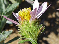 California aster |
More plants on the trail
Bayside Trail - Similar Hikes
All Contents © Copyright The American Southwest | Comments and Questions | Contribute | Affiliate Marketing Disclosure | Site Map