Arizona - Videos
 A brief view of one of the narrowest sections of Aravaipa Canyon, about 2.5 miles from the western trailhead, where the shallow, fast-flowing creek is bordered by vertical walls of reddish-grey Precambrian schist. Followed by a gila monster, walking beside the stream. (0:46 min) |
 Scenes along the Bright Angel Trail, from the Bright Angel trailhead to Plateau Point, including the 1.5 and 3 mile resthouses, Garden Creek, Indian Garden, the Tonto West trail junction and Plateau Point - a 12.6 mile round trip hike that took just less than 5 hours on a hot and sunny May day. (2:48 min; 42.7 mb) |
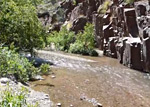
 A few scenes in the granite narrows of Hance Creek, and of Sockdolager Rapids and the Colorado River, at the end of the canyon. Reached by a long hike starting with the Grandview Trail and a short section of the Tonto Trail. (1:04 min; 35 mb) |
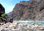
 Hance Rapids on the Colorado River, at the end of the 8 mile New Hance Trail down Red Canyon - at river mile 77 in the Grand Canyon. (0:51 min; 6.8 mb) |
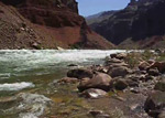
 Three locations along the 8.5 mile Hermit Trail - a pool and waterfall in the lower narrows of Hermit Creek, Hermit Rapids on the Colorado River at the end of the trail, and a Grand Canyon rattlesnake on grassy slopes above the Tonto Bench. (1:07 min; 21 mb) |
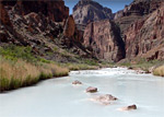 The Little Colorado River, a little way upstream and downstream of the end of Salt Trail Canyon, reached by the 3 mile Salt Trail. Also pools, cascades and an unusual travertine waterfall in the lower part of Big Canyon, which meets the river half a mile east. (2:22 min) |
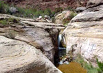
 Eight scenes in the watery narrows of Pumphouse Wash, an upper tributary of Oak Creek - from the first pool near the trailhead, through the flooded slot canyon section, to the largest pool reached after nearly 3 miles, just past the junction with James Canyon. (0:54 min; 10.4 mb) |
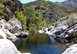
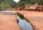 The largest pool along the 4.9 mile Woods Canyon Trail, south of Sedona; up to 300 feet long and 100 feet across, bordered by flat red slickrock of the Supai Formation. (1:12 min) |
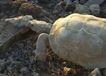 An aged desert tortoise at sunset in early summer, on the summit of Lost Horse Peak - a small hill near I-8 exit 140 in the Sonoran Desert National Monument of south central Arizona. (1:11 min; 9.4 mb) |
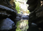
 Pools and cascades near the East Fork confluence in Sabino Canyon - reached by a 3 mile hike along the Sabino Canyon Trail then a short walk cross-country to the creek. (0:44 min) |
All Contents © Copyright The American Southwest | Comments and Questions | Contribute | Affiliate Marketing Disclosure | Site Map