Sycamore Canyon Overlook Trail, Sycamore Canyon
Arizona > Sycamore Canyon > Sycamore Canyon Overlook Trail
Sycamore Canyon Overlook Trail
Lightly-used route that follows part of the shoreline of White Horse Lake then crosses open pine woodland to a viewpoint on the rim of Sycamore Canyon, on a promontory separating the main drainage from a short side ravine
Length: 1.8 miles
Elevation change: 100 feet
Difficulty: Easy
Type: One-way
Usage: Low
Season: Spring, summer, fall - affected by snow in the winter
Trailhead: West side of White Horse Lake, 13 miles from I-40 (exit 167)
Rating (1-5): ★★★★★
Elevation change: 100 feet
Difficulty: Easy
Type: One-way
Usage: Low
Season: Spring, summer, fall - affected by snow in the winter
Trailhead: West side of White Horse Lake, 13 miles from I-40 (exit 167)
Rating (1-5): ★★★★★

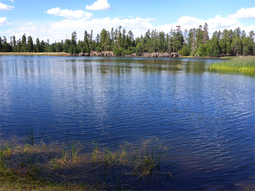
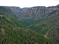
The upper reaches of Sycamore Canyon can be viewed at Sycamore Falls and along the Sycamore Rim Trail, while Sycamore Point overlooks the deep, wide, middle section, but apart from these the only other easily-reached viewpoint is at the end of the short Canyon Overlook Trail (#70), which starts from White Horse Lake, the main center for recreation activities near the canyon. The lake itself, a natural feature, is popular for boating and fishing (swimming is not permitted), while the spacious campsite set amongst tall ponderosa pines along its western edge can accommodate RVs of up to 38 feet, so the place makes a good base from which to explore the surrounding, varied scenery of the Kaibab Plateau.
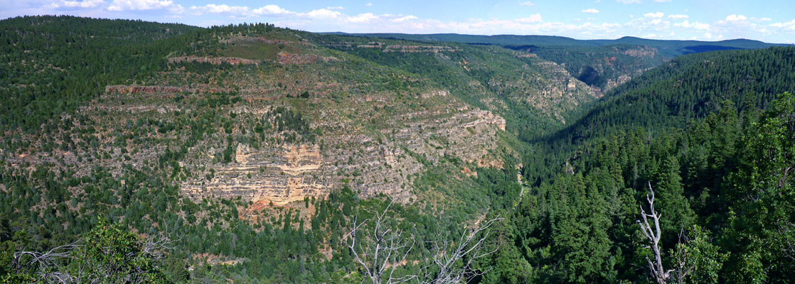
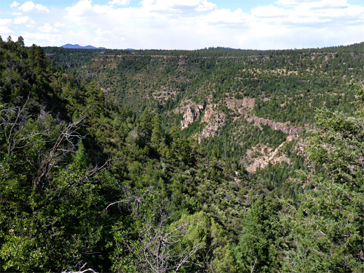
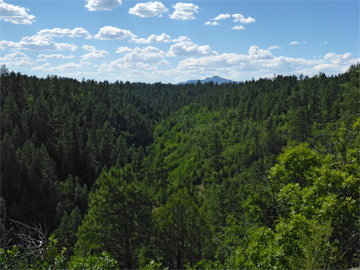
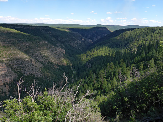
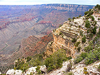
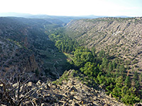
The Overlook Trail, which is not so much used, follows part of the lakeshore, crosses a seasonal drainage - the stream draining the lake, and continues across a flat, sparsely tree-covered plateau to a viewpoint on the edge of the canyon, here about 1,000 feet deep. Most of the canyon sides are thickly wooded, without much exposed sandstone, so the vista is not as spectacular compared to others up and downstream, yet is still quite dramatic.
Sycamore Canyon overview map.
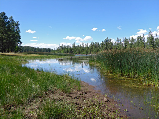
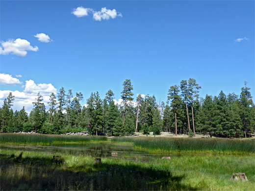
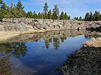
White Horse Lake is 13 miles from exit 167 of Interstate 40, mostly on good gravel tracks; FR 146, FR 141 and FR 109. Paved roads lead close to the shoreline on the north and west sides of the lake, to the main campground, the group camp, day use areas and the boat launch ramp. The entrance road is open between May and September though the lake accessible to hiking at all time. The lake is very popular in summer, especially for fishing (brown trout, rainbow trout and channel catfish); at this time there is usually a mobile restaurant stationed here, and regular campfire programs are staged. The campground has 90 sites, no hookups.
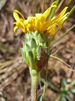
Start point for the hike is at one of the day use areas, halfway along the western shore. The path, initially the White Horse Lake Loop (#33), heads southeast through the forest, staying a little way from the shoreline which is muddy and marshy, lined by grass and reeds, and frequented by cows, as is the whole area. In summer thousands of frogs live around the water's edge. The trail rounds the south end of the lake, passes one junction and soon reaches a second, signed Overlook Trail. This descends through another patch of trees and crosses a meadow on the floor of a shallow valley, containing the lake's outlet stream, usually dry. It climbs the far side, follows a fence above the valley rim before moving away across a sparsely wooded flat, over a minor gully then across a longer open area to the viewpoint. This is near the end of a narrowing promontory between the main canyon to the east and a smaller ravine to the west, the lower end of the drainage crossed earlier. The best views are from the southern tip, a short distance beyond the end of the official trail.
The Overlook Trail, which is not so much used, follows part of the lakeshore, crosses a seasonal drainage - the stream draining the lake, and continues across a flat, sparsely tree-covered plateau to a viewpoint on the edge of the canyon, here about 1,000 feet deep. Most of the canyon sides are thickly wooded, without much exposed sandstone, so the vista is not as spectacular compared to others up and downstream, yet is still quite dramatic.
Location
Sycamore Canyon overview map.
White Horse Lake
White Horse Lake is 13 miles from exit 167 of Interstate 40, mostly on good gravel tracks; FR 146, FR 141 and FR 109. Paved roads lead close to the shoreline on the north and west sides of the lake, to the main campground, the group camp, day use areas and the boat launch ramp. The entrance road is open between May and September though the lake accessible to hiking at all time. The lake is very popular in summer, especially for fishing (brown trout, rainbow trout and channel catfish); at this time there is usually a mobile restaurant stationed here, and regular campfire programs are staged. The campground has 90 sites, no hookups.

The Overlook Trail
Start point for the hike is at one of the day use areas, halfway along the western shore. The path, initially the White Horse Lake Loop (#33), heads southeast through the forest, staying a little way from the shoreline which is muddy and marshy, lined by grass and reeds, and frequented by cows, as is the whole area. In summer thousands of frogs live around the water's edge. The trail rounds the south end of the lake, passes one junction and soon reaches a second, signed Overlook Trail. This descends through another patch of trees and crosses a meadow on the floor of a shallow valley, containing the lake's outlet stream, usually dry. It climbs the far side, follows a fence above the valley rim before moving away across a sparsely wooded flat, over a minor gully then across a longer open area to the viewpoint. This is near the end of a narrowing promontory between the main canyon to the east and a smaller ravine to the west, the lower end of the drainage crossed earlier. The best views are from the southern tip, a short distance beyond the end of the official trail.
Sycamore Canyon Overlook - Similar Hikes
All Contents © Copyright The American Southwest | Comments and Questions | Contribute | Affiliate Marketing Disclosure | Site Map