Hope Camp Trail, Saguaro National Park
Arizona > Saguaro National Park > East > Hiking > Hope Camp Trail
Hope Camp Trail
Old vehicle track that crosses bushy land and some riparian areas, still with many large saguaros, to a pair of abandoned cattle stations; Deer Camp after 1.25 miles and Hope Camp at the end
Length: 2.8 miles
Elevation change: Level overall
Difficulty: Easy
Type: One-way
Usage: Low to medium
Season: Fall to spring; summers are very hot
Trailhead: North end of Camino Loma Alta
Rating (1-5): ★★★★★
Elevation change: Level overall
Difficulty: Easy
Type: One-way
Usage: Low to medium
Season: Fall to spring; summers are very hot
Trailhead: North end of Camino Loma Alta
Rating (1-5): ★★★★★

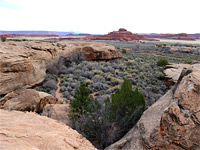
The 2.8 mile Hope Camp Trail is a lightly-used route along the south edge of the eastern (Rincon Mountain) section of Saguaro National Park, away from the busier area along Fremont Road, accessed instead by a dead-end road (unpaved for the final 0.6 miles) off the Old Spanish Trail in Rincon Valley; this ends at a small, rocky parking place accommodating a dozen or so vehicles, also used for the short Ridge View Trail. Overflow spaces are available on verges up to a quarter of a mile back.
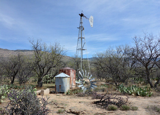
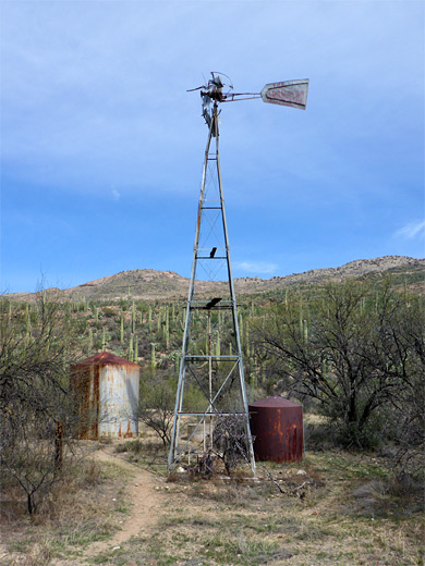
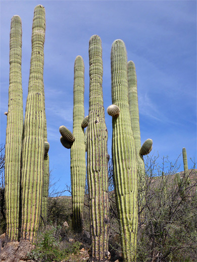
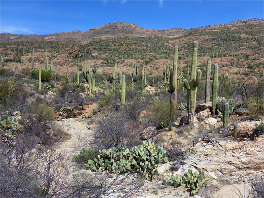
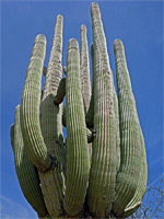
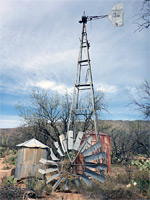
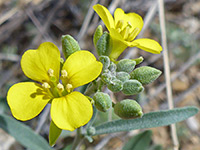
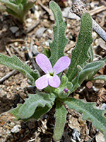
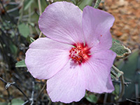
The main path, which is level overall, follows the valley of a tributary of Rincon Creek, past the remains of a mid 20th-century cattle station (Deer Camp), then crosses a minor saddle and descends gently close to another tributary, ending beside a second station, Hope Camp. Both have a windmill - the former made by Aermotor, the latter by F Rondstadt - plus metal tanks, concrete troughs and a few wooden relics. The two drainages are usually dry apart from several damp, riparian thickets, while the surrounding slopes are covered with a good number of saguaro cacti, some especially large and branched. Many wildflower species bloom in late spring. The trail is one of only two in the park that is also open to cycles, the other being the Cactus Forest Loop.
Map of the east section of Saguaro National Park.
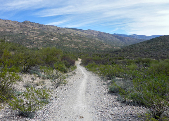
The path, formerly a vehicle track, heads northwest, very soon passing the junction with the Ridge View Trail, then crosses a low brow and descends gently to a belt of mesquite trees along the valley floor. It crosses a tributary creekbed and follows the main branch, staying in shady surroundings for a while, a mix of trees and saguaro. The Coyote Wash Trail forks off, following the valley southwards, and forming a 4 mile loop together with the Ruiz Trail, which joins the Hope Camp route a little further on.
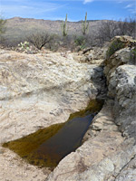
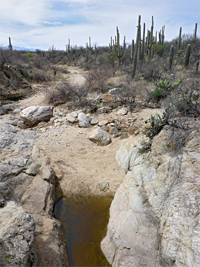
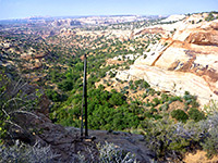
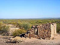
Deer Camp comes into view ahead, close to the wash on the opposite (north) side; just beyond is an open, rocky slope with good views across a vast array of cacti, towards Tanque Verde Ridge. This is the high point of the trail, and the land opens out ahead giving an uninterrupted eastwards panorama across to the higher peaks of the Rincon Mountains. The path starts the descent of an exposed slope, down to a grassy flat, again with trees and saguaro, some very tall. The recently-constructed Quilter Trail branches off northwards, named after a former NPS employee, and this also forms part of the cross-state Arizona Trail, bypassing an earlier alignment. Hope Camp is not far ahead, its windmill rising above a cluster of mesquite, cholla and opuntia, and this marks the usual end of the hike, though the Arizona Trail continues south a short distance, up to a fence along the edge of private land, then exits the national park through a gate. One other point of interest, just east of the camp along another branch of the creek (beyond a fence) is a tinaja or water hole - a rock-lined pool that retains water for a long time after rainfall.
The main path, which is level overall, follows the valley of a tributary of Rincon Creek, past the remains of a mid 20th-century cattle station (Deer Camp), then crosses a minor saddle and descends gently close to another tributary, ending beside a second station, Hope Camp. Both have a windmill - the former made by Aermotor, the latter by F Rondstadt - plus metal tanks, concrete troughs and a few wooden relics. The two drainages are usually dry apart from several damp, riparian thickets, while the surrounding slopes are covered with a good number of saguaro cacti, some especially large and branched. Many wildflower species bloom in late spring. The trail is one of only two in the park that is also open to cycles, the other being the Cactus Forest Loop.

Location
Map of the east section of Saguaro National Park.
Start of the Trail
The path, formerly a vehicle track, heads northwest, very soon passing the junction with the Ridge View Trail, then crosses a low brow and descends gently to a belt of mesquite trees along the valley floor. It crosses a tributary creekbed and follows the main branch, staying in shady surroundings for a while, a mix of trees and saguaro. The Coyote Wash Trail forks off, following the valley southwards, and forming a 4 mile loop together with the Ruiz Trail, which joins the Hope Camp route a little further on.
Deer Camp and Hope Camp
Deer Camp comes into view ahead, close to the wash on the opposite (north) side; just beyond is an open, rocky slope with good views across a vast array of cacti, towards Tanque Verde Ridge. This is the high point of the trail, and the land opens out ahead giving an uninterrupted eastwards panorama across to the higher peaks of the Rincon Mountains. The path starts the descent of an exposed slope, down to a grassy flat, again with trees and saguaro, some very tall. The recently-constructed Quilter Trail branches off northwards, named after a former NPS employee, and this also forms part of the cross-state Arizona Trail, bypassing an earlier alignment. Hope Camp is not far ahead, its windmill rising above a cluster of mesquite, cholla and opuntia, and this marks the usual end of the hike, though the Arizona Trail continues south a short distance, up to a fence along the edge of private land, then exits the national park through a gate. One other point of interest, just east of the camp along another branch of the creek (beyond a fence) is a tinaja or water hole - a rock-lined pool that retains water for a long time after rainfall.
Hope Camp Trail - Similar Hikes
All Contents © Copyright The American Southwest | Comments and Questions | Contribute | Affiliate Marketing Disclosure | Site Map