Cottonwood Wash, Lake Mead National Recreation Area
Arizona > Lake Mead National Recreation Area > Cottonwood Wash
Cottonwood Wash
Shallow drainage through a geologically-varied area near the north shore of Lake Mead; rocks of many colors and forms, including some short sections of narrows
Length: 1.8 miles, to the confluence of two upper tributaries
Elevation change: 350 feet
Difficulty: Easy
Type: One way, a route rather than a trail
Usage: Low
Season: Fall, winter, spring; summers are very hot
Trailhead: Pullout along Northshore Road (Hwy 167), 25 miles from Boulder Highway
Rating (1-5): ★★★★★
Elevation change: 350 feet
Difficulty: Easy
Type: One way, a route rather than a trail
Usage: Low
Season: Fall, winter, spring; summers are very hot
Trailhead: Pullout along Northshore Road (Hwy 167), 25 miles from Boulder Highway
Rating (1-5): ★★★★★

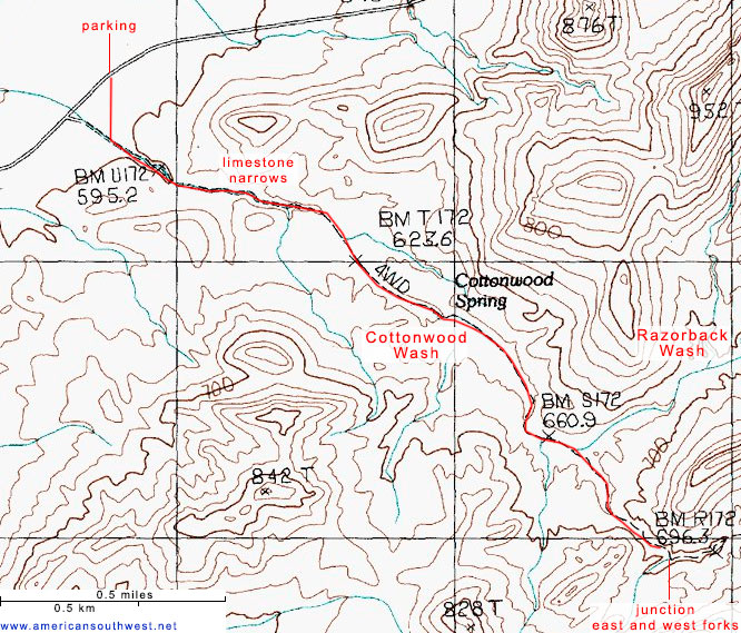
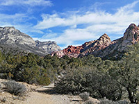
Cottonwood Wash is a short, seasonal drainage near the north shore of Lake Mead; starting in a region of small hills and gullies between Razorback Ridge and Hamblin Mountain, the usually dry streambed runs northwest for 2 miles then under Northshore Road and across a desert plain to a confluence with Callville Wash. The section upstream of the road makes for an interesting hike, taking just a couple of hours - the wash runs through a geologically varied region, across at least ten different sedimentary layers, passing rocks of many different colors and forms, including grey (fossiliferous) limestone and dark red conglomerate.
The wash is named for a cluster of cottonwood trees about halfway along, at a spring, though a flash flood several years ago washed away most of the trees. Apart from this place, the drainage is completely dry for most of the year. The walk up the creekbed is along the course of an old road, though this is barely evident, and the hike is generally easy, with just a few minor obstacles to pass, the biggest a sloping pour-off in a narrow place just above the spring.
Besides the colorful rocks and interesting geology, the wash is also notable for a good variety of plants and insects, and it offers wide-ranging views over the surrounding hills and valleys.
Map of Lake Mead National Recreation Area.
23 views of Cottonwood Wash.
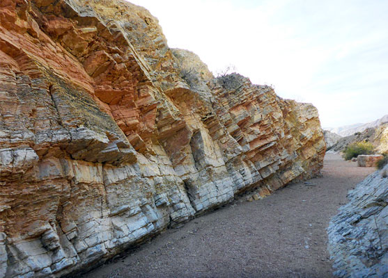
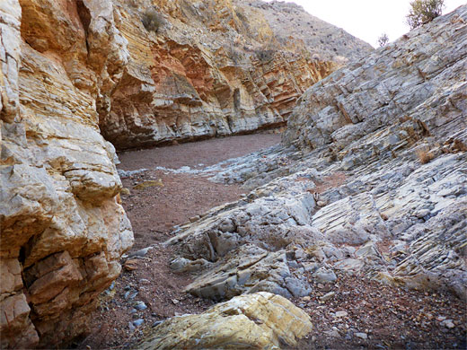
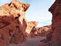
The Cottonwood Wash hike begins from a paved, unsigned pullout on the north side of Northshore Road (Hwy 167), 25 miles east of the Boulder Highway in Henderson - in the middle of a vast desert plain, ringed by scenic hills including a red ridge to the north, part of the Bowl of Fire. On the opposite side of the road, a faint path heads south a short distance over pebbly desert pavement to the wash, descending to the streambed; the remainder of the hike simply involves following the drainage upstream. The wash soon narrows as it enters the first band of rocks, a mix of reddish sandstone and grey conglomerate, both members of the Horse Spring Formation, soon followed by brief outcrops of the Chinle Formation and the Kaibab Formation; next is a minor dryfall at the start of a 1000 foot-long section of medium-width narrows through inclined, greyish layers of Virgin limestone, part of the Moenkopi Formation. Some of the rocks here contain fossils, including shells, worm tracks and ripples.
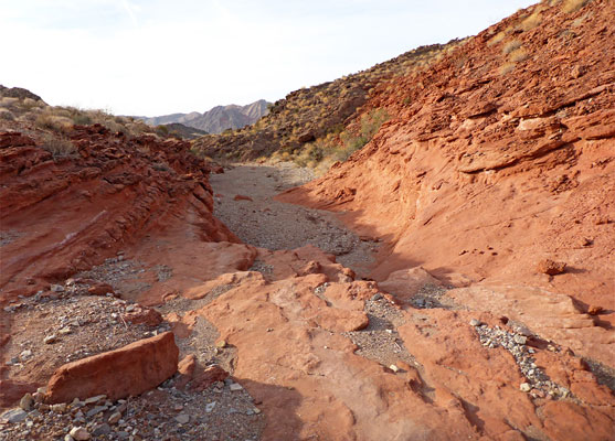
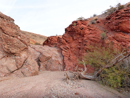
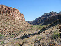
They wash widens after the limestone, still heading southeast, now through the upper red member of the Moenkopi Formation, which extends to Cottonwood Spring, just below a narrow place along the streambed, and at the junction with a minor, south-side tributary where the old road along the canyon once diverted, to avoid the sloping dryfall in the narrows. Several cottonwood trees still grow here, next to the spring. Rocks above are now red, from the rainbow garden member of the Horse Spring Formation, mainly conglomerate.
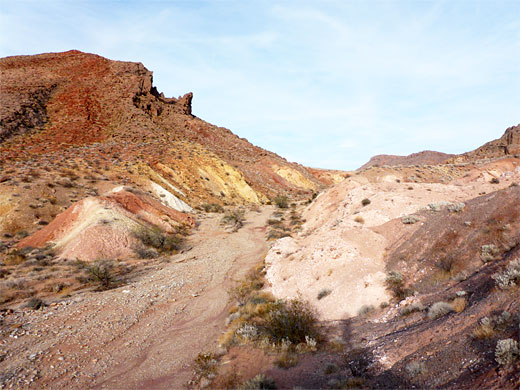
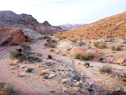
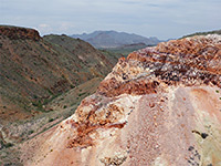
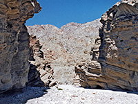
The red rock stretch extends to a bigger junction, where Razorback Wash joins from the north. Cottonwood Wash bends to the south, through a jumble of small ridges, from the thumb member of the Horse Spring Formation, rocks that include many veins of calcite, followed by reddish strata of the Chinle Formation, as the wash reaches another junction, in front of a big sloping wall of multicolored strata. Here it splits into east and west forks, running each way at the foot of the wall, and both can be followed though they soon become shallow, and branch again, so the junction makes an obvious point to turn around, at the end of the hike.
The wash is named for a cluster of cottonwood trees about halfway along, at a spring, though a flash flood several years ago washed away most of the trees. Apart from this place, the drainage is completely dry for most of the year. The walk up the creekbed is along the course of an old road, though this is barely evident, and the hike is generally easy, with just a few minor obstacles to pass, the biggest a sloping pour-off in a narrow place just above the spring.
Besides the colorful rocks and interesting geology, the wash is also notable for a good variety of plants and insects, and it offers wide-ranging views over the surrounding hills and valleys.
Location
Map of Lake Mead National Recreation Area.
Photographs
23 views of Cottonwood Wash.
Start of the Hike
The Cottonwood Wash hike begins from a paved, unsigned pullout on the north side of Northshore Road (Hwy 167), 25 miles east of the Boulder Highway in Henderson - in the middle of a vast desert plain, ringed by scenic hills including a red ridge to the north, part of the Bowl of Fire. On the opposite side of the road, a faint path heads south a short distance over pebbly desert pavement to the wash, descending to the streambed; the remainder of the hike simply involves following the drainage upstream. The wash soon narrows as it enters the first band of rocks, a mix of reddish sandstone and grey conglomerate, both members of the Horse Spring Formation, soon followed by brief outcrops of the Chinle Formation and the Kaibab Formation; next is a minor dryfall at the start of a 1000 foot-long section of medium-width narrows through inclined, greyish layers of Virgin limestone, part of the Moenkopi Formation. Some of the rocks here contain fossils, including shells, worm tracks and ripples.
Cottonwood Spring
They wash widens after the limestone, still heading southeast, now through the upper red member of the Moenkopi Formation, which extends to Cottonwood Spring, just below a narrow place along the streambed, and at the junction with a minor, south-side tributary where the old road along the canyon once diverted, to avoid the sloping dryfall in the narrows. Several cottonwood trees still grow here, next to the spring. Rocks above are now red, from the rainbow garden member of the Horse Spring Formation, mainly conglomerate.
Upper end of Cottonwood Wash
The red rock stretch extends to a bigger junction, where Razorback Wash joins from the north. Cottonwood Wash bends to the south, through a jumble of small ridges, from the thumb member of the Horse Spring Formation, rocks that include many veins of calcite, followed by reddish strata of the Chinle Formation, as the wash reaches another junction, in front of a big sloping wall of multicolored strata. Here it splits into east and west forks, running each way at the foot of the wall, and both can be followed though they soon become shallow, and branch again, so the junction makes an obvious point to turn around, at the end of the hike.
Topographic Map
Cottonwood Wash - Similar Hikes
All Contents © Copyright The American Southwest | Comments and Questions | Contribute | Affiliate Marketing Disclosure | Site Map