Highlights:
Many archaeological sites from the Ancestral Puebloans, on barren plains east of Winslow. Two (Homolovi I and Homolovi II) have been partially reconstructed, and may be toured via short trails, while paths also lead to a viewpoint, some petroglyphs, and a historic cemetery
Nearby town:
Winslow, 7 miles
Management:
Location:
35.046, -110.652 (visitor center)
Seasons:
All year
Rating (1-5):
★★★★★

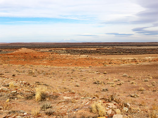
Homolovi State Park is a 4,500 acre preserve at the edge of the Painted Desert in northern Arizona, a few miles east of Winslow, and it is typically visited by around 30,000 people each year; one of the less popular parks in the state. Homolovi is a Hopi word meaning 'place of little hills', an accurate description as much of the land here is flat and sandy, though with just a few small peaks and mesas rising above, composed of the Chinle Formation (Shinarump Member), or the Moenkopi Formation (Holbrook and Moqui members).
The park was established, as Homolovi Ruins, in 1986, to protect over 300 Ancestral Puebloan sites, scattered across the desert; the word Ruins was removed from the title in 2011 after petitions from the Hopi tribe, who considered the structures still to have life, in a spiritual sense. Virtually all the sites are unexcavated, however, and just two are open to the public, and even these contain only low wall remnants, so overall, there is not so much to see. The park also has four short trails, to some petroglyphs, to a viewpoint, to an old cemetery, and a connecting trail.
The park was established, as Homolovi Ruins, in 1986, to protect over 300 Ancestral Puebloan sites, scattered across the desert; the word Ruins was removed from the title in 2011 after petitions from the Hopi tribe, who considered the structures still to have life, in a spiritual sense. Virtually all the sites are unexcavated, however, and just two are open to the public, and even these contain only low wall remnants, so overall, there is not so much to see. The park also has four short trails, to some petroglyphs, to a viewpoint, to an old cemetery, and a connecting trail.
Homolovi Table of Contents
Photographs
21 views of Homolovi State Park.
The State Park
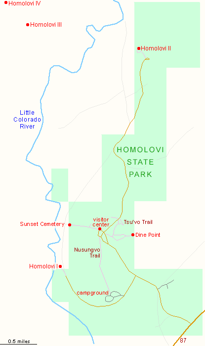
Homolovi is open year round, from 8 AM to 5 PM. The entrance road is along Hwy 87, one mile north of I-40 exit 257. A side road leads to the campground, and one of the two open sites (Homolovi I), then soon after is the visitor center where the entry fee is paid. The road continues another 3 miles, ending at the second site, Homolovi II. In addition to the two publicly open ruins are another two major pueblos, Homolovi III and Homolovi IV, plus many lesser sites.
Trails
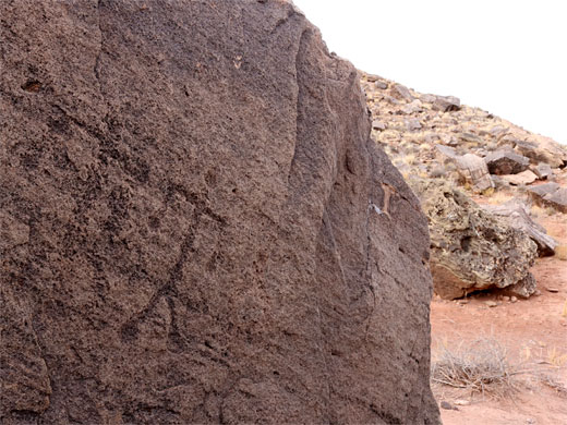
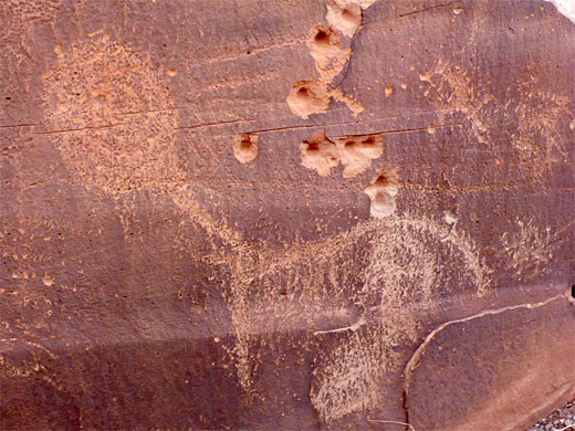
Beside the two short paths around the open ruins, Homolovi has four other trails. One, the Nusungvo Trail (0.9 miles), is a link route, running between the campground and the visitor center. Also starting at the center is the 0.5 mile Sunset Cemetery Trail to a small graveyard from the long disappeared settlement of Sunset, established by Mormon pioneer Lot Smith in 1876, and containing graves of several of his children. The remainder of the townsite was washed away by the adjacent Little Colorado River. The Dine Trail, 0.5 miles, heads east from visitor center to a viewpoint atop a small hill, while the nearby Tsu'vo Trail, 0.2 miles, leads to a gap between two buttes, to a group of boulders adored with a few faint petroglyphs, including spirals and human figures; some are damaged by bullet holes.
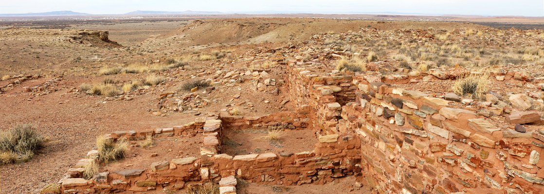
Homolovi I and Homolovi II
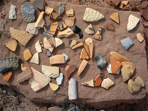
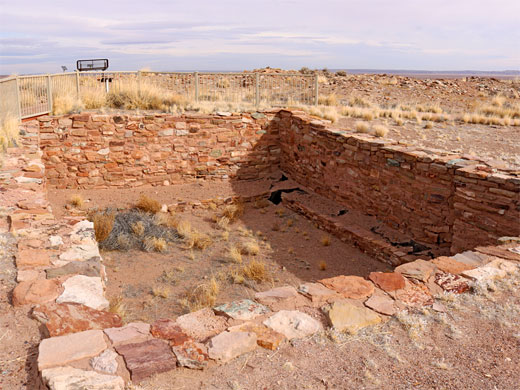
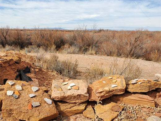
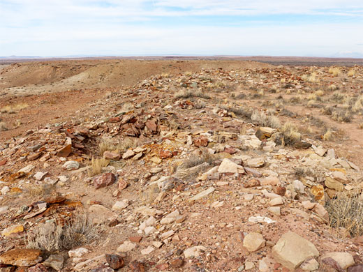
Homolovi I, at the end of the campground road, is the more fragmentary of the two open sites, with only a few foundations visible, situated on a low ridge just 200 feet from the Little Colorado River. More notable are the huge number of pottery fragments, amongst the ruins and all across the surrounding land. The village was occupied from around 1275 to 1400. Like all the Homolovi area, the site has extensive views in all directions, including west towards the San Francisco Peaks, 60 miles away. There is rather more to see at the Homolovi II site, at the far end of the park road, reached by a 0.2 mile trail. The settlement was 800 by 70 feet in dimensions, and several dozen rooms can still be identified, round or square, with a few being excavated and partly reconstructed, the walls up to 4 feet high. This pueblo was occupied between 1350 and 1400.
Homolovi - Nearby Places
- Meteor Crater (32 miles) - one of the best preserved meteorite impact craters on earth
- Petrified Forest National Park (50 miles) - the best location in the USA to see petrified wood
Homolovi - Similar Places
- Wupatki National Monument, Arizona - red rock ruins on mesa tops and the rims of shallow canyons
- Yapashi Pueblo, Bandelier National Monument, New Mexico - unexcavated backcountry ruin with many pottery fragments
All Contents © Copyright The American Southwest | Comments and Questions | Contribute | Affiliate Marketing Disclosure | Site Map