Highlights:
Little known, geologically unusual part of central Utah - an oval shaped area of uplifted rocks edged by a high ridge of angled strata, cutting through which are many narrow canyons. Also much rock art, and other historic sites
Nearby town:
Management:
Location:
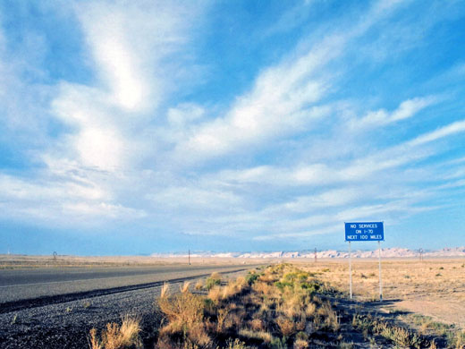
38.922, -110.443 (I-70 through the eastern reef)
Seasons:
All year. Access tracks may be inaccessible at times due to snow or heavy rainfall
Rating (1-5):
★★★★★
Weather:

San Rafael Swell - Scenic Drive
The best and most scenic of the many unpaved roads across the Swell, passing the San Rafael River and the Buckhorn Draw Pictograph Panel, plus a side track to the Wedge Overlook
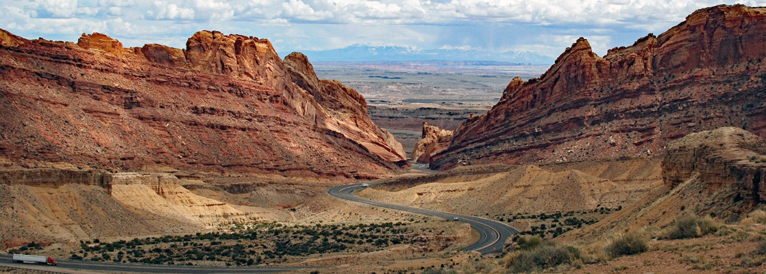
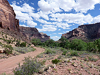
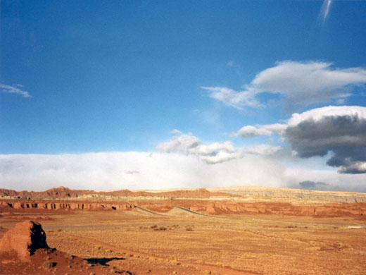
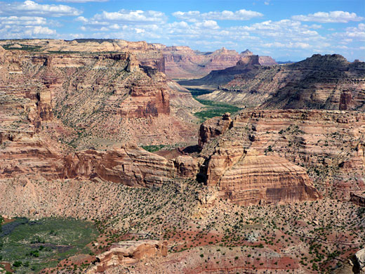
East of the Fishlake Mountains, I-70 cuts across one of the emptiest and least developed regions of Utah - a wide plateau crossed by two entrenched river systems and surrounded by a ring of upturned strata. This is the San Rafael Swell - arid, little vegetated yet often very scenic, with mesas, cliffs, buttes, springs and especially canyons; these are sometimes wide with stepped sides but often narrow and slot-like. Most is owned by the BLM and could well be a future national monument; for now though the land is open and access is unrestricted.
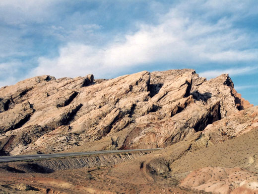
The Swell is an oval shaped uplifted area of layered rocks - geologically termed an anticline - about 75 by 40 miles in extent, most of which has been eroded away forming the mostly flat central plateau, while the strata at the edges are left exposed and angled near vertically (the San Rafael Reef); here are found most of the spectacular canyons, especially in the southeast section.
The Swell is an oval shaped uplifted area of layered rocks - geologically termed an anticline - about 75 by 40 miles in extent, most of which has been eroded away forming the mostly flat central plateau, while the strata at the edges are left exposed and angled near vertically (the San Rafael Reef); here are found most of the spectacular canyons, especially in the southeast section.
San Rafael Swell Table of Contents
- Map
- Photographs
- Scenic drive; Buckhorn Draw Road
- Access routes to the San Rafael Swell
- History and activities
- Hiking; rock art and slot canyons
- Temple Mountain
- Nearby places
- Similar places
Location
Map of the San Rafael Swell.
Photographs
General views, Buckhorn Draw Road, slot canyons.
Access to the San Rafael Swell
The largest town nearby is Green River, 18 miles east of the reef on I-70; this is also a convenient base from which to explore the Canyonlands region to the southeast and Desolation Canyon to the north. The town has a selection of shops and cheap motels, and the John Wesley Powell River Museum - besides its interesting exhibits this has a good selection of local books and topographic maps. UT 24 and its side roads give access to the southern swell, and along here is found Goblin Valley State Park, the most visited site in this area. The northern half falls between US 191/6 and UT 10 and amongst the routes heading inwards is the unpaved but good quality Buckhorn Draw Road which leads to the single most impressive viewpoint - the Wedge Overlook from where many square miles of eroded canyons around the San Rafael River are viewable.
History and Activities
Historically, the Swell was crossed by various expeditions during the exploration of the West but received virtually no permanent settlement. More recently, the area has seen sporadic mining operations - principally for uranium (most intensively around the Temple Mountain area) but also for small amounts of copper, silver, oil and gas; otherwise, ranching has been and continues to be the only major use of the land. Herds of wild horses and burros roam the plains, and bighorn sheep may sometimes be spotted in the canyons. Most of the tracks across the swell result from prospectors in the early to mid twentieth century, and these provided the only access until 1972, when the interstate was constructed, dividing the region in two. Various exits now allow easy entrance to the middle section and link with the old tracks, most of which are good for regular vehicles and quite well signposted. Hiking and exploring are the main reasons to visit nowadays - there are trails to mountains, historic sites, old mines and the numerous canyons - these offer experiences ranging from extended, strenuous trips like the hike through the Black Boxes of the San Rafael River to easy walks such as that down Little Wild Horse Canyon.
Temple Mountain
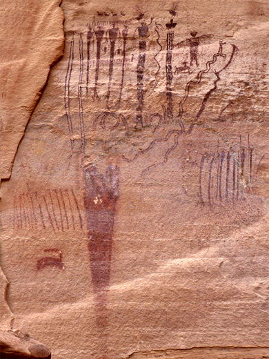
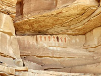
The most accessible area of the San Rafael Swell is around Temple Mountain in the southeast, beside the road to Goblin Valley State Park. Half way to the park (6 miles from UT 24), a side track branches off westwards and cuts right through the reef, the only such road along the whole eastern edge apart from interstate 70. There are many good places for free camping either side of the road, all with nice views over the reef and the San Rafael Desert - a good alternative to staying at the Goblin Valley campground, where the fees (2024) are $45 a night. The road becomes unpaved but still fine for all vehicles as it follows the canyon of South Temple Wash into the reef, where multicolored walls of Wingate sandstone rise up to 500 feet. Two sections of the cliffs on the north side have quite impressive pictograph panels, though mixed with modern graffiti. The cliffs recede on the far side of the reef to reveal an angular landscape of numerous red ridges, ravines and cliffs, with a prominent peak to the north. This is Temple Mountain - site of one of the main mining areas in the Swell, it was in use from 1910 to about 1960, extracting large amounts of uranium ore from strata of the Chinle formation. Many shafts, stone buildings, spoil heaps, rusty iron equipment and other debris remain in place, plus a large winch tower, and a walk around the mountain on old mine roads makes for an interesting hike of 2 hours or so. The rocky badlands beneath the mountain are also strewn with many pieces of petrified wood, the Chinle sandstone being the same formation as found in Arizona's Petrified Forest National Park. The old tracks branch off the main road at the site of Temple Mountain village, a settlement that was built to service the miners and once included a gas station and general store, though little trace remains today.
Hiking in the San Rafael Swell
Trails
Ferron Box
★★★★★
★★★★★
2.4 miles, 400 feet
Rock art along Ferron Creek, on the west side of the Swell; most is pictographs, on low sandstone cliffs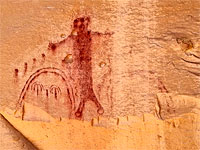
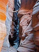
Narrow canyons of the Swell, mostly along the south and east edges; a few are quite well known, especially Little Wild Horse, but most are remote, hidden and rarely visited.
Baptist Draw/Upper Chute Canyon
★★★★★
★★★★★
7 miles, 600 feet
Long, deep and narrow slot canyons, perhaps the best in the Swell, through colorful, nicely eroded rocks; equal in beauty and extent to the Navajo canyons of Page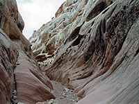
Bell Canyon
★★★★★
★★★★★
1.8 miles, 200 feet
Short ravine, not very narrow or enclosed, but bordered by nicely eroded rocks, with a great variety of textures and colors. Often hiked as part of a loop with adjacent Little Wild Horse Canyon.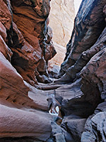
Cistern and Ramp Canyons
★★★★★
★★★★★
8.1 miles, 500 feet (loop)
Pair of deep canyons through the steeply-angled rocks at the southwest edge of the Swell, forming short narrows sections containing a few pools and chokestones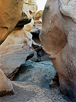
Crack Canyon
★★★★★
★★★★★
2.3 miles, 400 feet
Three sections of angular narrows between more open sections, all likely to contain pools and mud. The surrounding rock is unusually varied in texture and color. Explorable as a short one-way hike or a longer loop through adjacent Chute Canyon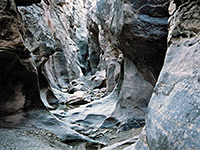
Crawford Draw
★★★★★
★★★★★
1.5 miles, 200 feet
Upper tributary of Eardley Canyon, starting (via its own tributary, Reid Nelson Draw) with a photogenic section through fine stratified rock filled with long, semi-permanent pools, then a deeper stretch enclosed by spooky greyish rocks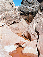
Ding and Dang Canyons
★★★★★
★★★★★
6 miles, 500 feet (loop)
Two short ravines through the San Rafael Reef; quite narrow, though V-shaped and not enclosed, containing a selection of pools and chokestones. A good variety of rock textures en route.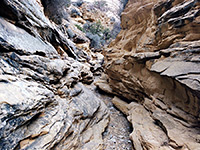
Devils Canyon
★★★★★
★★★★★
4.8 miles, 500 feet
Deep canyon with a few slot sections and miles of medium-width passageways through dull-colored sandstone, joined many narrow, branched but fairly shallow tributaries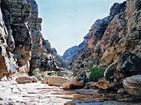
Eardley Canyon
★★★★★
★★★★★
5 miles, 800 feet
Spectacular, hidden ravine; an upper narrows section through inclined limestone of many thin layers, becoming much deeper downstream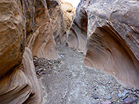
Farnsworth Canyon
★★★★★
★★★★★
2.7 miles, 80 feet
Short, moderately narrow drainage through angled, thin-layered rocks. No obstructions, so easily explored; reached by a dirt track off the road to Goblin Valley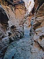
Forgotten Canyon
★★★★★
★★★★★
1.8 miles, 300 feet
Short, moderately narrow but quite pretty slot towards the lower end of a much longer ravine, a tributary of Eagle Canyon on the west side of the Swell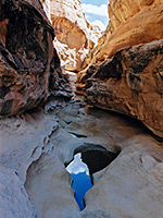
Iron Wash, North Fork
★★★★★
★★★★★
10.5 miles, 600 feet
Remote, scenic, technical slot, the upper end of which can be seen without rappelling, though it still contains some deep potholes, and needs a long cross-country walk to reach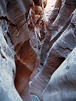
Little Wild Horse Canyon
★★★★★
★★★★★
1.8 miles, 400 feet
Most visited location in the Swell - a long, very narrow slot canyon through nicely colored rocks, easily accessed and not difficult to explore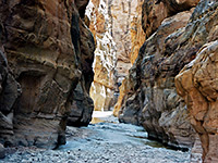
Muddy Creek
★★★★★
★★★★★
9 miles, 450 feet
Deepest canyon in the Swell, containing a stream most of the year, flowing through 3 miles of narrows ('The Chute'), resembling some of the canyons in Zion National Park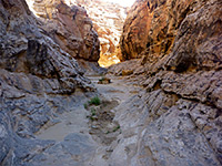
Music Canyon
★★★★★
★★★★★
4 miles, 1000 feet
East side tributary of Muddy Creek, deep and enclosed for just over a mile, and containing three sheer drops where ropes are neededSan Rafael Swell - Nearby Places
- Goblin Valley State Park - thousands of strangely-shaped formations at the edge of the Reef
San Rafael Swell - Similar Places
- Cottonwood Canyon Road, Utah - backcountry route alongside an uplifted ridge (the Coxcomb)
- Ojito Wilderness Area, New Mexico - remote wilderness area, and an anticline
All Contents © Copyright The American Southwest | Comments and Questions | Contribute | Affiliate Marketing Disclosure | Site Map