The best paths are to Devils Hall, Guadalupe Peak, Hunter Peak/the Bowl (via the Bear Canyon and Tejas Trails) and McKittrick Canyon.
Guadalupe Mountains Trailheads: Dog Canyon | Frijole Ranch | McKittrick Canyon | Pine Spring Canyon
The Guadalupe Mountains National Park Map shows the location of each trail.

Guadalupe Mountains National Park Trails - Dog Canyon
|
Bush Mountain Length 1.8 miles (2.9 km) to Marcus Overlook; 2.8 miles (4.5 km) to the Marcus Trail; 8.1 miles (13 km) to the summit; 11.0 miles (17.7 km) to the Tejas/Bowl Trail Elevation change 900 feet (274 meters) to Marcus Overlook; 2430 feet (741 meters) to the summit Trailhead Dog Canyon, north side of the park Rating (1-5) ★★★★★ This long backcountry path first follows a side drainage up to a viewpoint on top of a ridge (Marcus Overlook), descends the steeper west face into the West Fork of Dog Canyon (past a junction with the Marcus Trail), then climbs again into the Brokeoff Mountains, which form part of the western crest of the Guadalupe Range. The forested ridgeline is followed southwards for several miles to the second highest peak in the national park (and in all Texas), 8,631 foot Bush Mountain, after which the path turns east and descends gradually to a junction with the Tejas and Bowl trails, above Pine Spring Canyon. |
|
Indian Meadow Length 0.6 miles (1 km) (loop) Elevation change level Trailhead Dog Canyon, north side of the park Rating (1-5) ★★★★★ The tree-lined Indian Meadow, at the foot of a steep, 1,000 foot hillside, is toured by this short nature trail, accompanied by notices about the local plants and wildlife. |
|
Marcus Length 4.3 miles (6.9 km) Elevation change 1400 feet (427 meters) Trailhead Along the Bush Mountain Trail Rating (1-5) ★★★★★ The Marcus Trail crosses hilly, partly wooded land in the north of the park, from a junction with the Bush Mountain Trail in West Dog Canyon, southwards alongside the drainage then climbing quite high above, ending at an intersection with the Tejas Trail near South McKittrick Canyon. |
|
Tejas See the description under Pine Spring Canyon. A good day hike destination along the north section of the Tejas Trail is Lost Peak after 3.2 miles (1,540 feet elevation gain). |
Guadalupe Mountains National Park Trails - Frijole Ranch
|
Foothills Length 0.7 miles (1.1 km) Elevation change 160 feet (49 meters) Trailhead Start of the side road to Frijole Ranch Rating (1-5) ★★★★★ The short Foothills Trail runs between a corral beside the Frijole Ranch road junction and the Frijole Trail near the park headquarters, over dry washes and grassy slopes with scattered bushes and cacti. |
|
Frijole Length 2.7 miles (4.3 km) Elevation change 500 feet (152 meters) Trailhead Frijole Ranch Rating (1-5) ★★★★★ Frijole is a connecting path linking Frijole Ranch with the Tejas Trail near Pine Spring campground; the Bear Canyon Trail forks off northwards about half way along, leading into the high country of the Bowl. |
Smith Spring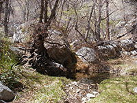 Length 2.3 miles (3.7 km) (loop) Elevation change 220 feet (67 meters) Trailhead Frijole Ranch Rating (1-5) ★★★★★ This easy loop first leads to Manzanita Spring, in a grassy clearing close to Frijole Ranch, then climbs up open hillsides below Frijole Ridge to the larger Smith Spring, set in shady maple/oak/pine woodland in a small canyon. The return is via another path a little way west. The first section to Manzanita Spring (0.2 miles) is paved and accessible to wheelchairs. |
Guadalupe Mountains National Park Trails - McKittrick Canyon
McKittrick Canyon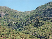 Length 2.4 miles (3.9 km) to Pratt Cabin; 3.4 miles (5.5 km) to the Grotto; 5.4 miles (8.7 km) to McKittrick Ridge; 8.1 miles (13.0 km) to the Tejas Trail Elevation change 200 feet (61 meters) to Pratt Cabin; 400 feet (122 meters) to the Grotto; 2700 feet (822 meters) to McKittrick Ridge; 2700 feet (884 meters) to the Tejas Trail Trailhead End of a paved side road off US 62/180 Rating (1-5) ★★★★★ McKittrick is the most scenic canyon in the national park - a shallow stream flows year-round, and the lower few miles have abundant vegetation and wildlife. Two possible destinations for a day hike are an old wooden cabin after 2.4 miles and a limestone grotto after 3.4 miles; both have a small picnic area nearby. Beyond the grotto the trail climbs very steeply above the valley, up to 7,716 foot McKittrick Ridge, (location of a backcountry campsite), then crosses more undulating terrain along the edge of an escarpment to a junction with the Tejas Trail. |
|
McKittrick Nature Trail Length 0.9 miles (1.4 km) (loop) Elevation change 150 feet (46 meters) Trailhead McKittrick Canyon visitor center Rating (1-5) ★★★★★ Notices about the plant and animal life of the Chihuahuan Desert accompany the McKittrick Nature Trail, an easy loop to a small spring on the hillside west of the McKittrick Canyon visitor center. |
Permian Reef Trail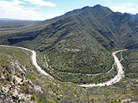 Length 4.8 miles (7.7 km) to the park boundary Elevation change 2000 feet (610 meters) Trailhead End of a paved side road off US 62/180 Rating (1-5) ★★★★★ The Permian Reef Trail ascends the north side of McKittrick Canyon, gaining height steadily via many switchbacks up to flat-topped Wilderness Ridge (7,000 feet, location of a primitive campsite), then continues northwards into the Lincoln National Forest. Numbered signs en route correspond to articles in a geology guidebook sold at the national park visitor center. |
Guadalupe Mountains National Park Trails - Pine Spring Canyon (Park Headquarters)
Bear Canyon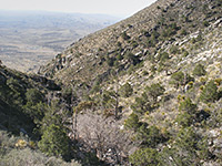 Length 1.5 miles (2.4 km) Elevation change 2000 feet (610 meters) Trailhead Far side of the NPS campground Rating (1-5) ★★★★★ Bear Canyon is a steep drainage east of Pine Spring Canyon; the path up the ravine is a less used alternative to the Tejas Trail for reaching the Guadalupe Mountains backcountry. It starts along the Frijole Trail in the desert foothills and ends at a junction with the Bowl Trail, in cool pine woodland at 8,000 feet. Although steep and rocky, much of the route is shaded by trees and in shadow during the morning, unlike the more exposed Tejas Trail. |
Bowl Length 4.7 miles (7.6 km) (loop) Elevation change 600 feet (183 meters) Trailhead North end of the Bear Canyon Trail Rating (1-5) ★★★★★ High above the desert lowlands, the sheltered pine and fir forest of the Bowl is circled by a loop trail that connects the Bear Canyon and Tejas trails and has a 0.3 mile spur to the summit of 8,368 foot Hunter Peak. Another junction is with the Juniper Trail, an alternative connector to the Tejas Trail for continuation trips further north. |
Devils Hall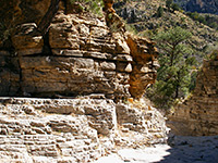 Length 2.1 miles (3.4 km) Elevation change 750 feet (229 meters) Trailhead Far side of the NPS campground Rating (1-5) ★★★★★ Devil's Hall is a narrow, 200 foot deep, vertical-walled ravine through thin-layered limestone strata, and may be reached by a fairly level trail up Pine Spring Canyon. The last mile is over pebbles and boulders along the streambed. |
|
El Capitan Length 3 miles (4.8 km)/3.8 miles (6.1 km) to the junctions with the Salt Basin Trail; 9.5 miles (15.3 km) to Williams Ranch Elevation change 400 feet (122 meters)/500 feet (152 meters) to the Salt Basin Trail; 1300 feet (396 meters) to Williams Ranch Trailhead At the NPS campground Rating (1-5) ★★★★★ This long but relatively flat trail winds across desert hillsides south of El Capitan peak, passing cactus flats, dry washes and rocky outcrops with two junctions en route, with the start and end of the Salt Basin Trail to the south. The El Capitan path, now rather less traveled, continues further west and descends Shumard Canyon to Williams Ranch, a disused building reachable by a 7 mile 4WD track from US 62/180. |
Guadalupe Peak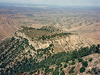 Length 4.2 miles (6.8 km) Elevation change 2940 feet (896 meters) Trailhead At the NPS campground Rating (1-5) ★★★★★ The highest peak in Texas rises nearly 3,000 feet above Pine Spring campground, starting point for the strenuous trail to the summit. The path is very steep in places but well maintained and has fantastic views all the way. |
|
Pinery Length 0.35 miles (0.6 km) Elevation change 100 feet (30 meters) Trailhead Parking area along US 62/180 Rating (1-5) ★★★★★ The short, paved Pinery Trail has exhibits about desert life; it starts at the national park visitor center/headquarters and ends at a parking area along US 62/180, beside the ruins of a station on the Butterfield Overland Mail route. |
|
Salt Basin Length 3 miles (4.8 km) Elevation change 450 feet (137 meters) Trailhead 3 miles along the El Capitan Trail Rating (1-5) ★★★★★ The 3 mile Salt Basin Trail branches off the El Capitan Trail after 3 miles, rejoining it 0.8 miles later after descending a little alongside Guadalupe Canyon then traversing a flat limestone plateau to the west. There are good views over the desert 2,000 feet below, and of Salt Basin further to the west. |
Tejas Length 3.3 miles (5.3 km) to the Bowl Trail; 4.8 miles (7.7 km) to the Juniper Trail; 6.3 miles (10.1 km) to the Marcus Trail; 7.8 miles (12.6 km) to the McKittrick Canyon Trail; 11.0 miles (17.7 km) to Dog Canyon Elevation change 2100 feet (640 meters), to the Bowl Trail Trailhead At the NPS campground Rating (1-5) ★★★★★ The longest trail in the Guadalupe Mountains links the park headquarters at the mouth of Pine Spring Canyon with the northern entrance in Dog Canyon - 11 miles in all, across a succession of ridges and valleys. The steepest but most used section is the southernmost 3.3 miles, which form part of the 9 mile loop to Hunter Peak, also involving the Bowl, Bear Canyon and Frijole trails. There are three primitive campsites along the way, and junctions with several other paths including the Marcus, Juniper and McKittrick Canyon trails. |
All Contents © Copyright The American Southwest | Comments and Questions | Contribute | Affiliate Marketing Disclosure | Site Map