Most routes begin along the park's paved roads but a few need a 4WD vehicle to reach the trailhead - in particular those in the middle section of the Rio Grande, south of the Chisos Mountains. Some of the most popular trails are Boquillas Canyon, Dog Canyon, Lost Mine, Santa Elena Canyon and Window.
Big Bend Trails: Southwest | Southeast | Chisos Mountains and the North
The Big Bend National Park Map shows the location of each trail - identified by the number.
Chisos Mountains topographic map.

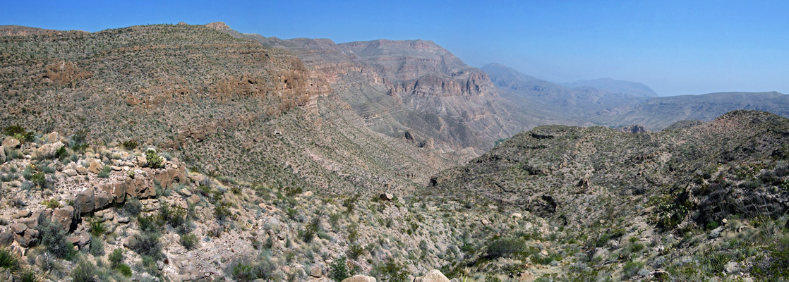
Big Bend National Park Trails - the Southwest
1. Apache Canyon Trail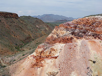 Length 4.4 miles (7.1 km) to the rocks Elevation change 230 feet (70 meters) Trailhead Pull-out along Ross Maxwell Scenic Drive Rating (1-5) ★★★★★ Remote ravine on the west side of Burro Mesa containing unusual, brightly colored rocks, reached by a little-used trail across flat, grassy land. The latter section of the path descends into an adjacent drainage containing two historic ruins; the rocks are reached by a short, off-trail continuation hike. |
2. Blue Creek Canyon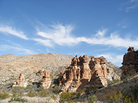 Length 1.5 miles (2.4 km) to the red rocks; 5.5 miles (8.8 km) to the Laguna Meadow Trail Elevation change 240 feet (73 meters) Trailhead Pullout on the east side of Ross Maxwell Scenic Drive Rating (1-5) ★★★★★ A disused but well preserved homestead (Homer Wilson Ranch; 0.3 miles) and a group of pointed red rock formations are the two attractions of the first 2 miles of the trail along Blue Creek Canyon, a route that continues upstream for several more miles, gaining height steadily, into the high country of the Chisos Mountains, where it meets the Laguna Meadows segment of the inner loop trail, this 2,460 feet above the trailhead. |
3. Burro Mesa Pouroff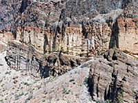 Length 0.5 miles (0.8 km) Elevation change 50 feet (15 meters) Trailhead End of a paved side road forking off Ross Maxwell Scenic Drive Rating (1-5) ★★★★★ This well used path to a narrow pouroff crosses sandy ground then follows a dry wash to the base of the cliffs; the drainage continues high above (reached by the separate Upper Burro Mesa Pouroff Trail). The lower path is accessed from a paved side road, forking off Ross Maxwell Scenic Drive. |
4. Cattail Falls Trail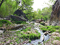 Length 1.5 miles (2.4 km) Elevation change 360 feet (110 meters) Trailhead Along Oak Spring Road, east of Ross Maxwell Scenic Drive Rating (1-5) ★★★★★ Cattail Falls is a beautiful, hidden waterfall above an enchanting series of pools, in a wooded canyon on the west side of the Chisos Mountains; reached by a little-publicized trail across undulating desert hills. The falls are home to several rare plants. |
|
5. Chimneys Length 2.4 miles (3.9 km) to the Chimneys; 7.0 miles (11.3 km) to Luna's Jacal Elevation change 400 feet (122 meters), to the Chimneys Trailhead Along Ross Maxwell Scenic Drive Rating (1-5) ★★★★★ The Chimneys Trail heads west from a start point along the Ross Maxwell Scenic Drive, descending gradually over a vast desert plain beneath Kit Mountain, to a conspicuous volcanic dyke - the chimneys. After here the path stays on wide open desert land, close to a large dry wash and eventually reaches an old adobe cabin (Luna's Jacal), just off the gravel Maverick Road. |
|
6. Dodson Length 11 miles (17.7 km) Elevation change 1200 feet (366 meters) Trailhead Pullout on the east side of Ross Maxwell Scenic Drive Rating (1-5) ★★★★★ Forming part of the Outer Mountain Loop, the Dodson Trail is a long cross-country route through the southern foothills of the Chisos Mountains. It begins in the west at Homer Wilson Ranch, near the Blue Creek Canyon trailhead, and leads across ridges, valleys, creeks and wide washes, meeting the Juniper Canyon Trail after nearly 11 miles. |
|
7. Grapevine Hills Length 1.1 miles (1.8 km) Elevation change 200 feet (61 meters) Trailhead Near the end of Grapevine Hills Road Rating (1-5) ★★★★★ Seven miles along the unpaved Grapevine Hills Road, a short trail forks off southeast, ascending a sandy wash lined by large rounded boulders, some balanced quite precariously. The hike is considered a good choice for families with children. |
|
8. Mesa de Anguila Length 16 miles (25.7 km) loop - or longer Elevation change varies Trailhead Southeast edge of Lajitas Rating (1-5) ★★★★★ A loop and several spur trails cross particularly remote, hot and little visited terrain in the far west section of the national park, around steep-sided Mesa de Anguila, close to the Rio Grande. There are two trailheads - one just outside Lajitas, the other at the end of a rough track south of FM 170. |
9. Mule Ears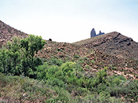 Length 1.9 miles (3.1 km) to Mule Ears Spring; 3.8 miles (6.1 km) to the Smoky Creek Trail Elevation change 100 feet (30 meters), to the spring Trailhead End of a spur road off Ross Maxwell Scenic Drive Rating (1-5) ★★★★★ The Mule Ears Spring trail winds over typical Chihuahaun Desert land of small peaks, sandy flats and dry washes, to a cottonwood tree-lined oasis. Start point is Mule Ears Overlook, along the Ross Maxwell Scenic Drive 8 miles north of Castolon. Past the spring, the trail continues to a junction with a backpacking route linking the Chisos Mountains with the River Road. |
10. Santa Elena Canyon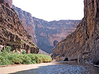 Length 0.8 miles (1.3 km) Elevation change 40 feet (12 meters) Trailhead End of Ross Maxwell Scenic Drive Rating (1-5) ★★★★★ Santa Elena is most spectacular canyon in the national park, formed as the Rio Grande cuts through the 1,200 foot cliffs of Sierra Ponce. The mouth of the canyon is reached by a popular trail that crosses the lower end of Terlingua Creek (wading may be necessary), climbs up and over a rocky outcrop and ends on a sandbank next to the river; beyond here the water covers all the canyon floor, but the river is often shallow enough to allow continuation hikes upstream. |
11. Tuff Canyon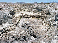 Length 0.5 miles (0.8 km), loop Elevation change level Trailhead Along Ross Maxwell Scenic Drive Rating (1-5) ★★★★★ There are many box canyons in Big Bend - shallow but sheer-walled ravines, cutting across the desert plains. Tuff Canyon is a good example, located right next to the Ross Maxwell Scenic Drive and viewable by a short trail. An optional extension is to descend into the canyon and follow the streambed through the narrows |
12. Upper Burro Mesa Pouroff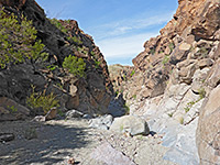 Length 1.8 miles (2.9 km) Elevation change 200 feet (61 meters) Trailhead Along Ross Maxwell Scenic Drive Rating (1-5) ★★★★★ The increasingly narrow and rocky ravine formed by Javelina Wash provides a course for a primitive but relatively easy trail that ends at the top of a 100 foot dryfall, at the edge of Burro Mesa. The foot of the pouroff is reached by a separate, shorter path; both begin along the Ross Maxwell Scenic Drive. |
13. Ward Spring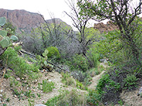 Length 1.6 miles (2.6 km) Elevation change 450 feet (137 meters) Trailhead Small pullout on the east side of Ross Maxwell Scenic Drive Rating (1-5) ★★★★★ Minor water source in a shallow, overgrown ravine, along the upper section of Cottonwood Creek - in the western foothills of the Chisos Mountains. The lightly used trail crosses open flats and small ridges, past a good selection of cacti and wildflowers. |
Big Bend National Park Trails - the Southeast
14. Boquillas Canyon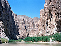 Length 0.7 miles (1.1 km) Elevation change 40 feet (12 meters) Trailhead End of the paved road running east from Rio Grande Village Rating (1-5) ★★★★★ The entrance to Boquillas Canyon, one of the three great river gorges within Big Bend National Park, can be reached by a short trail that climbs over a ridge then passes through a riparian area close to the Rio Grande, ending at a pebbly beach. At times of low water it is possible to continue some distance downstream, by a combination of walking along sand banks and wading in the river. |
|
15. Chihuahuan Desert Length 0.5 miles (0.8 km) (loop) Elevation change level Trailhead Dugout Wells picnic area Rating (1-5) ★★★★★ Many kinds of cacti and other Chihuahuan Desert plants can be seen on this nature loop trail, beside Hwy 118 at the Dugout Wells picnic area, 6 miles east of Panther Junction. |
16. Hot Springs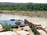 Length 3 miles (4.8 km) Elevation change 250 feet (76 meters) Trailhead End of a spur road west of Rio Grande Village Rating (1-5) ★★★★★ The Hot Springs alongside the Rio Grande can be reached either by a gravel track (not for RVs), leaving Hwy 118 a few miles from Rio Grande Village, or by a pleasant 3 mile trail, crossing desert land with many and varied cacti, and frequent views of the river gorge (Hot Springs Canyon). The trail starts a little way west of the village, at the end of the spur road to Daniels Ranch. |
|
17. Marsical Canyon Length 3.3 miles (5.3 km) to the canyon viewpoint; 10.0 miles (16.1 km) to Solis Landing Elevation change 1200 feet (366 meters), to the viewpoint Trailhead Near the south end of Talley Road Rating (1-5) 1 Unlike the other two major gorges along the Rio Grande, the trail to Marsical Canyon climbs high above the river, to an overlook at the edge of the sheer cliffs that enclose the river 1,200 feet below. Start point is at the end of Talley Road, which in turn is reached from the River Road, a total of at least 30 miles along rough tracks - 4WD vehicles recommended. After the viewpoint the path continues across remote country to an alternative trailhead at the end of Solis Road. |
18. Marufo Vega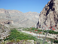 Length 14 miles (22.5 km) (loop) Elevation change 1000 feet (305 meters) Trailhead Near the end of the road to Boquillas Canyon Rating (1-5) ★★★★★ Perhaps the most difficult day hike in Big Bend, the Marufo Vega loop trail crosses hostile, mountainous terrain, exceedingly hot and dry during the summer months, and descends steeply down a canyon to the banks of the Rio Grande, deep within Boquillas Canyon. The route follows the river bank for a mile then returns via an equally steep climb up an adjacent ravine. |
|
19. Ore Terminal Length 4 miles (6.4 km) Elevation change 960 feet (293 meters) Trailhead Near the end of the road to Boquillas Canyon Rating (1-5) ★★★★★ Ruins of the northern terminus of a six mile ore tramway provide an unusual destination for a fairly strenuous hike across ridges and dry washes, in low desert country west of Boquillas Canyon. Some of the path runs alongside iron cables and wooden trestles from the tramway, which once crossed the Rio Grande to a mine in Mexico. The trailhead is shared with the Marufo Vega loop, along the side road east of Rio Grande Village. |
|
20. Rio Grande Village Length 0.4 miles (0.6 km) Elevation change 40 feet (12 meters) Trailhead Site 18, Rio Grande Village Campground Rating (1-5) ★★★★★ Starting at the Rio Grande Village campground, this nature trail crosses a small wetland area (good for bird watching) on a boardwalk then climbs to a summit for views over the Rio Grande into Mexico. |
|
21. Telephone Canyon Length 14 miles (22.5 km) Elevation change 1800 feet (549 meters) Trailhead Old Ore Road Rating (1-5) ★★★★★ Competing with the Mesa de Anguila Trail to be the roughest and most remote hiking route in the Bend area, the Telephone Canyon Trail begins along Old Ore Road (HCV required) and heads eastwards to the park boundary, initially across several narrow ridges and then, after a steep descent, all along Telephone Canyon, a long and deep drainage through the Sierra Del Carmen mountains. |
Big Bend National Park Trails - Chisos Mountains and the North
|
22. Boot Canyon Length 1.5 miles (2.4 km) Elevation change 400 feet (122 meters) Trailhead South end of the Boot Spring Trail Rating (1-5) ★★★★★ The path along upper Boot Canyon begins at the end of the Boot Spring Trail, on the south side of the Chisos Mountains, and forms part of the shortest route to the South Rim from Chisos Basin. It climbs slowly up the winding, forested ravine then passes over a narrow ridge to one of the most spectacular views in the park. |
|
23. Boot Spring Length 1.3 miles (2.1 km) Elevation change 160 feet (49 meters) Trailhead South end of the Pinnacles Trail Rating (1-5) ★★★★★ This path forms a southerly continuation of the Pinnacles Trail from Chisos Basin, descending gradually into the upper reaches of Boot Canyon, past the spring, to a junction with the Boot Canyon Trail. Another intersection is with the Colima Trail, part of the Inner Mountain Loop. |
|
24. Colima Length 1 miles (1.6 km) Elevation change 350 feet (107 meters) Trailhead South end of the Boot Spring Trail Rating (1-5) ★★★★★ The Colima Trail is a one mile connecting path between the Boot Canyon, Boot Spring and Laguna Meadow trails, running up and down a forested saddle just south of 7,825 foot Emory Peak. |
25. Devils Den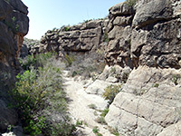 Length 3.5 miles (5.6 km) Elevation change 300 feet (91 meters) Trailhead Pullout on the east side of US 385 Rating (1-5) ★★★★★ A primitive, cairned trail forks south off the well-used route to Dog Canyon after about 1 mile, following dry washes to the Devil's Den - a narrow slot-like canyon through limestone cliffs, where upstream progress requires scrambling over small dryfalls and other obstacles. |
26. Dog Canyon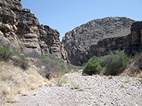 Length 2 miles (3.2 km) Elevation change 40 feet (12 meters) Trailhead Pullout on the east side of US 385 Rating (1-5) ★★★★★ Dog Canyon is a short but narrow and steep-walled limestone gorge cutting through the Santiago Mountains, near the northern park entrance at Persimmon Gap. The easy trail to the mouth of the canyon crosses desert flats filled with many species of cacti. |
27. Emory Peak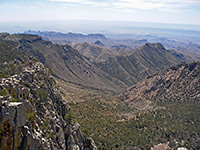 Length 1 miles (1.6 km) Elevation change 900 feet (274 meters) Trailhead South end of the Pinnacles Trail Rating (1-5) ★★★★★ The trail to the summit of Emory Peak, the highest point in the national park, climbs steadily up a mostly forested ridge, ending with a short scramble up a near-vertical cliff. The path is reached by the 3.5 mile Pinnacles Trail, making the round trip to the summit about 9 miles (2,450 foot elevation gain). |
|
28. Juniper Canyon Length 6.2 miles (10 km) Elevation change 3100 feet (945 meters) Trailhead End of Juniper Canyon Road Rating (1-5) ★★★★★ The Juniper Canyon Trail has the greatest elevation gain of any hike in the park - over 3,000 feet, from the desert flats in the upper end of the canyon (reached by a 12 mile drive over dirt roads), to the cool, wooded surroundings of Boot Canyon, in the southern Chisos Mountains. Most of the climb is in the last 3 miles - the first section is along the wide, cactus-covered canyon, where the ground slopes quite gently. |
|
29. Laguna Meadow Length 4.1 miles (6.6 km) Elevation change 1700 feet (518 meters) Trailhead Chisos Basin Rating (1-5) ★★★★★ Offering a longer but less steep alternative to the Pinnacles Trail for accessing the high Chisos Mountains, the Laguna Meadow route climbs steadily from Chisos Basin alongside a streamway, up to a plateau on the west side of Emory Peak, site of the meadow and several primitive campsites. It meets the Blue Creek Canyon Trail, climbs another 250 feet and terminates at a junction with the Colima Trail. |
30. Lost Mine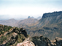 Length 2.4 miles (3.9 km) Elevation change 1200 feet (366 meters) Trailhead Pullout near the end of the road into Chisos Basin Rating (1-5) ★★★★★ From a pull-out along the Chisos Basin Road near Panther Pass, this often busy trail climbs a tree-covered hillside and a bushy ravine to a high, narrow ridge separating the upper ends of Juniper Canyon and Pine Canyon, providing an excellent introduction to the scenery of the Chisos Mountains. |
31. Oak Spring Trail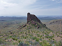 Length 2.3 miles (3.7 km) Elevation change 950 feet (290 meters) Trailhead Along Oak Spring Road, east of Ross Maxwell Scenic Drive Rating (1-5) ★★★★★ Connecting path between the desert lowlands and the Chisos Mountains; starts in the bushy valley below Oak Spring, climbs steadily to a ridge above the Window (a high pour-off) then descends into the canyon of Oak Creek, meeting the Window Trail. Many wildflowers on the mountain slopes. |
|
32. Pine Canyon Length 2 miles (3.2 km) Elevation change 800 feet (244 meters) Trailhead End of Pine Canyon Road Rating (1-5) ★★★★★ On the east side of the Chisos Mountains, Pine Canyon is a deep, shady ravine ending at a high dryfall, filled with tall trees of several different species. The path up the canyon begins at the end of a 6.4 mile primitive road that generally requires a 4WD vehicle. |
33. Pinnacles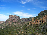 Length 3.5 miles (5.6 km) Elevation change 1600 feet (488 meters) Trailhead Large parking lot near Chisos Mountain Lodge Rating (1-5) ★★★★★ The Pinnacles Trail provides one of the two routes southwards from Chisos Basin into the high country of the Chisos Mountains. It starts by crossing the south side of the basin - bushy, sloping ground with somewhat limited views - then climbs steeply to a plateau between Emory Peak and Toll Mountain. From here the Boot Spring Trail continues further south while the Emory Peak Trail branches off westwards. |
|
34. Rim Length 5 miles (8 km) (loop) Elevation change 450 feet (137 meters) Trailhead South end of the Boot Canyon Trail Rating (1-5) ★★★★★ The South Rim of the Chisos Mountains is a dramatic escarpment, beyond which the ground drops precipitously by over 2,000 feet, giving fantastic views over the desert beyond, to the Rio Grande valley and Mexico. The closest viewpoint is 5.8 miles from Chisos Basin (via the Pinnacles, Boot Spring and Boot Canyon trails), from where the Rim Trail forks off east and west, looping around the edge of the plateau with only minor elevation changes. There are ten primitive camping sites en route. |
35. Window Trail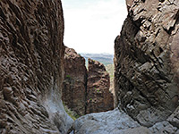 Length 2.2 miles (3.5 km) Elevation change 560 feet (171 meters) Trailhead Parking lot near Chisos Basin Campground Rating (1-5) ★★★★★ The Window Trail follows a streamway westwards (downstream), starting at the Chisos Basin campground and ending at the brink of a 200 foot dryfall, at the edge of mountains. The route becomes increasingly overgrown, and as the Window approaches the canyon is lined with oak trees and riparian vegetation. |
|
36. Window View Length 0.2 miles (0.3 km) Elevation change level Trailhead Chisos Basin Rating (1-5) ★★★★★ This very short path takes visitors to a viewpoint of the Window, the oft-photographed, V-shaped gap in the mountains that encircle all sides of Chisos Basin. |
All Contents © Copyright The American Southwest | Comments and Questions | Contribute | Affiliate Marketing Disclosure | Site Map