Zion Canyon Narrows
The most famous narrow canyon hike in the Southwest, following the North Fork of the Virgin River past near vertical walls up to 2,000 feet high. Generally passable only during late summer and fall, as the water is too deep and fast flowing at other times. The full canyon is best explored from the top (perhaps with one night camping en route), but most people start at the lower end and hike just a short distance upstream
Length: 8.5 miles to Deep Creek, 9.3 miles to Kolob Creek, 10.5 miles to Goose Creek, 13.1 miles to Orderville Canyon, 14.4 miles to Mystery Canyon, 15.6 miles to Temple of Sinawava
Difficulty: Moderate; no great obstacles, but miles of wading in the river
Management: NPS - within Zion National Park
Rocks: Navajo sandstone
Season: Late summer, fall
Trailhead: Near Chamberlain Ranch, 17.4 miles from UT 9. The lower trailhead is at Temple of Sinawava, shuttle stop 8
Rating (1-5): ★★★★★

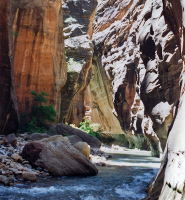
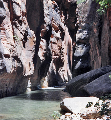
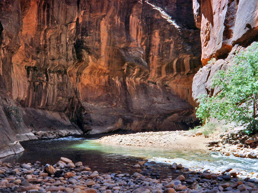
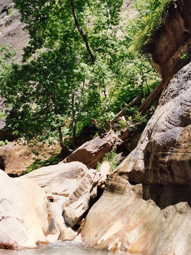
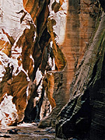
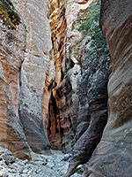
Beyond the paved trail at the north end of the scenic drive in Zion National Park, the 2,000 foot cliffs of Zion Canyon become closer together until the water covers all of the canyon floor, and the Virgin River continues for many miles, trapped beneath the near vertical walls of Navajo sandstone. Hiking upstream is possible for several months of the year during summer and autumn when the water level is relatively low, although always the danger of flash floods caused by sudden thunderstorms can make the trip too hazardous; every day, the flood danger level is posted by the NPS at the start of the trail.
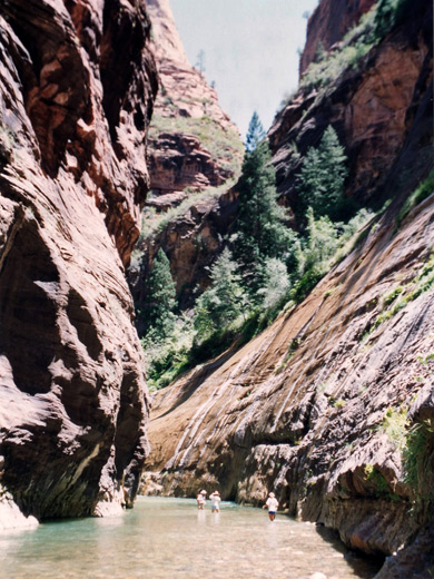
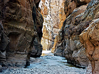
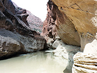
Much of the time is spent wading in the river water, sometimes chest-deep, but generally less. Care is needed at many points when crossing between sand banks due to the fast current and the rocky river bed, but this is still an unforgettable experience, thought by many to be the premier canyoneering experience in Utah.
The starting point for trips upstream through the Zion Narrows is the former parking area at Temple of Sinawava, at the end of the Zion Canyon Scenic Drive; this has a fresh water supply and noticeboards with maps & weather information, at the start of a 1 mile paved trail (Riverside Walk) after which the narrows begin. Private vehicles are no longer allowed along the drive; instead hikers arrive at the trailhead via the free Zion shuttlebus, starting at the visitor center by Watchman Campground. The reverse journey downstream requires a long drive (normally about 90 minutes) over unpaved tracks to reach a trailhead near Chamberlain's Ranch beside the North Fork of the Virgin River, above the start of the confined part of the canyon - this track is an extension of the road used to reach Orderville Canyon, and may be impassable during periods of wet weather. The distance between the two starting points of the Narrows hike is about 15 miles.
Regulations for backcountry travel in Zion National Park are becoming ever more restrictive, but still no permit is required for day trips up the Narrows, just a standard $35 (2024) park entry fee. However, for all overnight or through trips a permit is needed, currently 1-2 people: $15, 3-7 people: $20, 8-12 people: $25. Some of these are issued in limited numbers the day before travel, subject to a favorable weather forecast, while others can be reserved in advance. Permits are only issued if the river flow is less than 120 cfs. No groups larger than 12 are allowed in the Narrows, or anywhere else in the Zion backcountry.
The Virgin River trail is the most famous narrows hike in the US due to the length and depth of the canyon, and the spectacular scenery. Still, many people walk just a short distance up the gorge since one of the deepest parts of the river is only 100 yards up from the end of the paved trail and so far fewer progress beyond this point. There are many sand banks and boulders at the edges of the canyon allowing for some walking on land but at least half the hike involves wading and on occasions even swimming through the river. This is not practical in winter but fine during warmer months, when the water temperature is generally high enough for hikers not to feel cold even when wet from head to foot, if they keep moving.
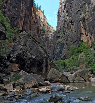
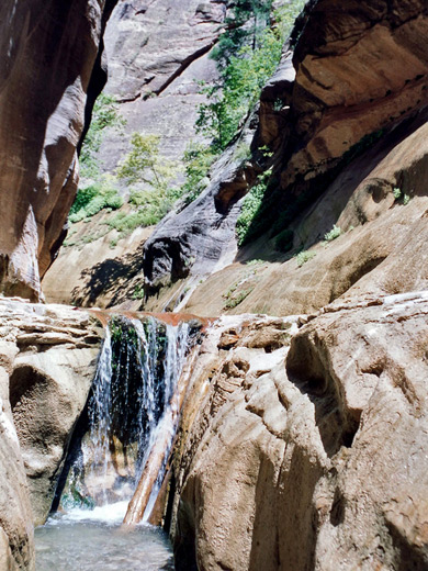
The river twists and turns, passing a few tributaries that join high above, such as Mystery Canyon, end of which is marked by a pretty cascade over a near-vertical, moss-covered cliff face. A good place to aim for on a half-day hike is Orderville Canyon, a long drainage that joins Zion Canyon from the east after 1.5 miles (2.5 miles from the trailhead). This too is a sheer-walled gorge, but has less water flowing through which enables quicker progress although it does have a few problematic pools and chokestones in the lower end. The deepest, narrowest part of the main canyon stretches for about two miles after the Orderville junction, then the cliffs gradually relent as sheer passages alternate with wider sections which have several designated places for camping. Other major side drainages, useful to gauge progress, are Goose Creek, Kolob Creek and Deep Creek.
The walk in the reverse (southbound) direction is of course rather easier as it is downstream. The deep, enclosed section of the canyon extends for about 13 miles in total, and can be hiked in one day although the trip is quite strenuous and most people spend at least one night camping. A variety of one-way trips are possible as there are several dirt tracks outside the park boundary in the Kolob Terrace area to the northwest which lead to the other tributaries of the river so if a car shuttle is available all can be used as starting points for the main narrows hike. The tributaries are generally more difficult to follow, however, and need rappelling equipment in some places.
Much of the time is spent wading in the river water, sometimes chest-deep, but generally less. Care is needed at many points when crossing between sand banks due to the fast current and the rocky river bed, but this is still an unforgettable experience, thought by many to be the premier canyoneering experience in Utah.
Location
The starting point for trips upstream through the Zion Narrows is the former parking area at Temple of Sinawava, at the end of the Zion Canyon Scenic Drive; this has a fresh water supply and noticeboards with maps & weather information, at the start of a 1 mile paved trail (Riverside Walk) after which the narrows begin. Private vehicles are no longer allowed along the drive; instead hikers arrive at the trailhead via the free Zion shuttlebus, starting at the visitor center by Watchman Campground. The reverse journey downstream requires a long drive (normally about 90 minutes) over unpaved tracks to reach a trailhead near Chamberlain's Ranch beside the North Fork of the Virgin River, above the start of the confined part of the canyon - this track is an extension of the road used to reach Orderville Canyon, and may be impassable during periods of wet weather. The distance between the two starting points of the Narrows hike is about 15 miles.
Permit
Regulations for backcountry travel in Zion National Park are becoming ever more restrictive, but still no permit is required for day trips up the Narrows, just a standard $35 (2024) park entry fee. However, for all overnight or through trips a permit is needed, currently 1-2 people: $15, 3-7 people: $20, 8-12 people: $25. Some of these are issued in limited numbers the day before travel, subject to a favorable weather forecast, while others can be reserved in advance. Permits are only issued if the river flow is less than 120 cfs. No groups larger than 12 are allowed in the Narrows, or anywhere else in the Zion backcountry.
Zion Canyoneering Adventures
Zion Narrows Route Description (from Temple of Sinawava)
The Virgin River trail is the most famous narrows hike in the US due to the length and depth of the canyon, and the spectacular scenery. Still, many people walk just a short distance up the gorge since one of the deepest parts of the river is only 100 yards up from the end of the paved trail and so far fewer progress beyond this point. There are many sand banks and boulders at the edges of the canyon allowing for some walking on land but at least half the hike involves wading and on occasions even swimming through the river. This is not practical in winter but fine during warmer months, when the water temperature is generally high enough for hikers not to feel cold even when wet from head to foot, if they keep moving.
Mystery and Orderville Canyons
The river twists and turns, passing a few tributaries that join high above, such as Mystery Canyon, end of which is marked by a pretty cascade over a near-vertical, moss-covered cliff face. A good place to aim for on a half-day hike is Orderville Canyon, a long drainage that joins Zion Canyon from the east after 1.5 miles (2.5 miles from the trailhead). This too is a sheer-walled gorge, but has less water flowing through which enables quicker progress although it does have a few problematic pools and chokestones in the lower end. The deepest, narrowest part of the main canyon stretches for about two miles after the Orderville junction, then the cliffs gradually relent as sheer passages alternate with wider sections which have several designated places for camping. Other major side drainages, useful to gauge progress, are Goose Creek, Kolob Creek and Deep Creek.
Tributaries
The walk in the reverse (southbound) direction is of course rather easier as it is downstream. The deep, enclosed section of the canyon extends for about 13 miles in total, and can be hiked in one day although the trip is quite strenuous and most people spend at least one night camping. A variety of one-way trips are possible as there are several dirt tracks outside the park boundary in the Kolob Terrace area to the northwest which lead to the other tributaries of the river so if a car shuttle is available all can be used as starting points for the main narrows hike. The tributaries are generally more difficult to follow, however, and need rappelling equipment in some places.
Zion is one of the top 25 slot canyons
Virgin River Narrows - Similar Hikes
All Contents © Copyright The American Southwest | Comments and Questions | Contribute | Affiliate Marketing Disclosure | Site Map