Slot canyons near Sedona, Arizona.
The popular tourist town of Sedona lies at the edge of the Colorado Plateau at the lower end of Oak Creek Canyon, one of several large ravines that cut into the exposed red sandstone. Many of the same strata also occur in the cliffs of the Grand Canyon - most visible are Kaibab limestone, the Supai formation and Coconino sandstone, and Oak Creek, like most canyons in this area, resembles those of the Colorado tributaries further north. They are deep and certainly spectacular but not particularly narrow. Many have permanent streams, and exploring them may involve much swimming across deep channels, particularly in the three most popular long canyons in this area, which do have some narrow sections: West Fork of Oak Creek, West Clear Creek, 24 miles south of Sedona - a 30 mile wilderness hike that encounters countless deep pools and pretty passages, and Wet Beaver Creek - 14 miles south of Sedona - this is a shorter canyon with pools, many large boulders and waterfalls.
Apart from the West Fork, there are several other branches of Oak Creek that have interesting rock formations and sometimes narrow sections, including James Canyon, Kelly Canyon and Pumphouse Wash. All may be entered either from the lower end starting at points along US 89 or AZ 179, or from the top via I-17 which has a number of little-used exits that link with dirt tracks heading west through the Coconino National Forest towards the edge of the cliffs. The following canyons may be explored (from north to south): Kelly (exit 333), James (exit 331), Munds (exit 322), Woods (exit 315) and Rattlesnake (exit 306).
James Canyon
★★★★★
★★★★★
3.4 miles, 750 feet
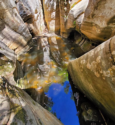
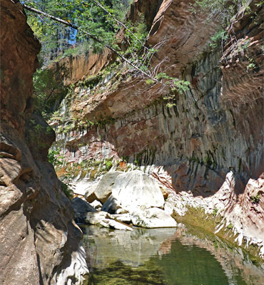
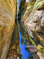
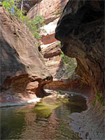
Deep, mostly cliff-lined canyon, a tributary of Pumphouse Wash, containing falls, pools and sections of narrows. Full exploration requires swimming and rapellingPumphouse Wash
★★★★★
★★★★★
2.9 miles, 450 feet
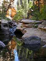
Scenic narrows, cascades, pools and extensive flooded slot-like channels along an upper tributary of Oak Creek, all enclosed by high, cream-colored Coconino sandstoneWest Fork of Oak Creek
★★★★★
★★★★★
3 miles, 200 feet
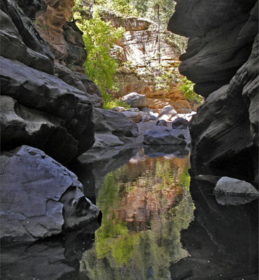
Perhaps the best hike in the Sedona area, along a deep, narrow, forested canyon with a permanent stream bordered by dramatic red rocks; explorable for many miles beyond the end of the official trailThe popular tourist town of Sedona lies at the edge of the Colorado Plateau at the lower end of Oak Creek Canyon, one of several large ravines that cut into the exposed red sandstone. Many of the same strata also occur in the cliffs of the Grand Canyon - most visible are Kaibab limestone, the Supai formation and Coconino sandstone, and Oak Creek, like most canyons in this area, resembles those of the Colorado tributaries further north. They are deep and certainly spectacular but not particularly narrow. Many have permanent streams, and exploring them may involve much swimming across deep channels, particularly in the three most popular long canyons in this area, which do have some narrow sections: West Fork of Oak Creek, West Clear Creek, 24 miles south of Sedona - a 30 mile wilderness hike that encounters countless deep pools and pretty passages, and Wet Beaver Creek - 14 miles south of Sedona - this is a shorter canyon with pools, many large boulders and waterfalls.
Apart from the West Fork, there are several other branches of Oak Creek that have interesting rock formations and sometimes narrow sections, including James Canyon, Kelly Canyon and Pumphouse Wash. All may be entered either from the lower end starting at points along US 89 or AZ 179, or from the top via I-17 which has a number of little-used exits that link with dirt tracks heading west through the Coconino National Forest towards the edge of the cliffs. The following canyons may be explored (from north to south): Kelly (exit 333), James (exit 331), Munds (exit 322), Woods (exit 315) and Rattlesnake (exit 306).
Related Sections
- Munds Canyon - deep ravine joining Oak Creek Canyon
- Sedona - general information
- Sycamore Canyon - colorful, wooded, little-visited canyon near Flagstaff
- West Clear Creek - deep canyon at the edge of the Mogollon Rim
All Contents © Copyright The American Southwest | Comments and Questions | Contribute | Affiliate Marketing Disclosure | Site Map