Highlights:
Remote, rather inaccessible red rock canyon with several tributaries, surrounded by a wooded plateau; similar to the landscapes around Sedona to the east
Nearby town:
Management:
USFS - part of the Coconino National Forest
Location:
Seasons:
Spring to fall; the approach roads are likely to be impassable during winter due to snow and mud
Rating (1-5):
★★★★★

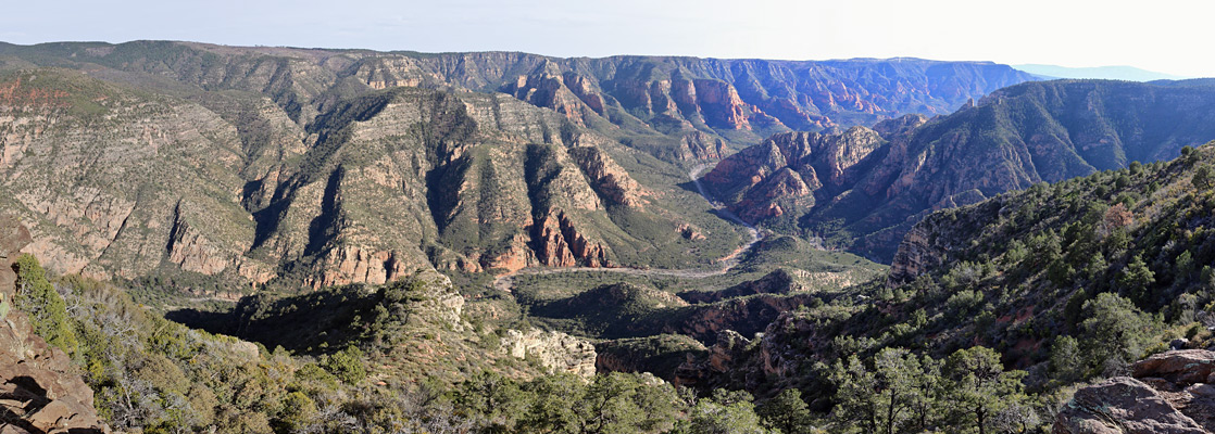
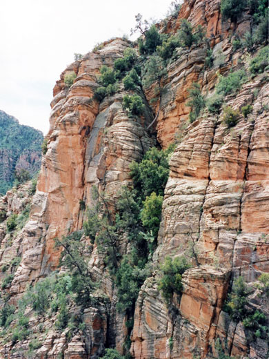
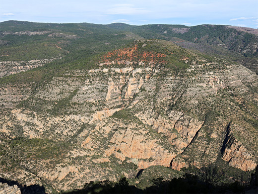
The spectacular red rock area around Oak Creek Canyon and Sedona is the second most popular tourist destination in Arizona, but just 15 miles west is another deep gorge of comparable size and beauty with many colorful sandstone formations, yet which is hardly ever visited. This is Sycamore Canyon, where Sycamore Creek and its tributaries have carved deep into the layered red rocks at the edge of the Colorado Plateau southwest of Flagstaff, creating a deep, branched canyon system extending for over 25 miles north to south. Unlike Oak Creek, however, there is no road through the canyon, and apart from one route to the southern end, the only approach is along lengthy unpaved tracks through the Kaibab and Coconino national forests south of Williams, hence visitation is very light.
The canyon starts as two upper forks, where a pair of minor, seasonal streams flowing across the flat, thickly, wooded land of the plateau finally have the strength to break through the relatively thin layer of hard lava that covers most of the land hereabouts, and erode into the softer underlying sandstone, soon forming sheer-walled gorges, 500 feet deep after only a quarter of a mile. The two branches meet after a couple of miles and the combined gorge runs southeast then south, deepening steadily, and ending in desert-like surroundings as the streambed meets the Verde River, over 3,000 feet lower in elevation.
The canyon starts as two upper forks, where a pair of minor, seasonal streams flowing across the flat, thickly, wooded land of the plateau finally have the strength to break through the relatively thin layer of hard lava that covers most of the land hereabouts, and erode into the softer underlying sandstone, soon forming sheer-walled gorges, 500 feet deep after only a quarter of a mile. The two branches meet after a couple of miles and the combined gorge runs southeast then south, deepening steadily, and ending in desert-like surroundings as the streambed meets the Verde River, over 3,000 feet lower in elevation.
Sycamore Canyon Table of Contents
- Map
- Photographs
- Approach poads
- Sycamore Point, the best canyon overlook
- Trails of Sycamore Canyon
- Featured Hikes
- Nearby places
- Similar places
Location
Map of Sycamore Canyon, showing roads and trails.
Photographs
Parsons Trail, Sycamore Rim.
Sycamore Canyon Approach Roads
A complex network of dirt and gravel tracks crosses the undeveloped, thickly wooded land that surrounds Sycamore Canyon to the west, north and east - see map. One of two most used approaches is from the west, starting from the paved Perkinsville Road (FR 173), which is the only main route that leaves Williams to the south, starting as 4th Street in town. After 8 miles, FR 110 (White Horse Lake Road) branches off eastwards, and along the way are signposts to several features of interest including two lakes (White Horse and J D Dam), both used for fishing and boating. White Horse Lake also has a campground, from where a 1.8 mile trail leads to a viewpoint on the canyon rim. The other popular approach is FR 146 from I-40 exit 167; this heads southeast, after 8 miles meeting FR 109, which links with FR 110 via White Horse Lake. FR 141 is another good access road, from exit 178 of the interstate, and together all these enable relatively easy travel to places on the north and northwest sides of the canyon, but the unpaved tracks from the east side are generally less good, and longer; the initial route is along FR 231 from Flagstaff, and there are many lesser roads beyond.
Sycamore Point
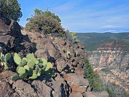
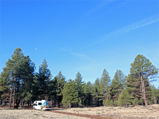
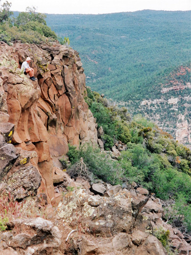
FR 110, a good quality road, continues to Sycamore Point, a remote, west-side overlook near the middle of Sycamore Canyon, at the end of a flat promontory where the land drops steeply on three sides. The drive to this point is 15 miles from FR 173 and takes almost one hour - there are various junctions, and the road deteriorates slightly, becoming quite narrow, sometimes rutted and bumpy, with one streambed crossing. For the last few miles, the dense pine forest is replaced by scattered bushes and the land becomes open and empty, with broad, grassy meadows and occasional rocky outcrops. There is no sign of the canyon until close to the edge, when the gorge comes suddenly into view - a great vista of red and orange rocks with covering greenery, a sight which is especially memorable at sunset. At the end of the road are several flat places suitable for camping, just a few feet from the cliff edge. At night the only visible signs of life are the twinkling lights of Cottonwood, far away to the south in the Verde River Valley. The atmosphere is especially peaceful on a perfectly clear sky day, free from any trace of artificial light. The land on the canyon rim is sparsely covered with bushes and small trees, and with a variety of subtly-colored wildflowers, such as skyrocket, harebell and several types of lily. It is easy to wander along the canyon edge and across the promontory to the west-facing rim, but there are no trails down into the canyon; however, although parts have sheer walls many feet high, it is just possible to climb down. The environment is quite different to the largely open ground on the plateau above as the sides are rocky and steep with many spiky cacti, thorny bushes and agaves with dagger-sharp leaves, that often hinder progress. It is quite an adventure to descend 1,500 feet to the sandy river bed below, which is dry for most of the year.
Trails of Sycamore Canyon
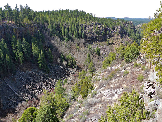
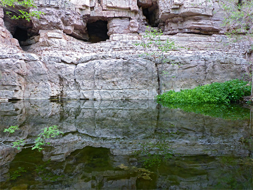
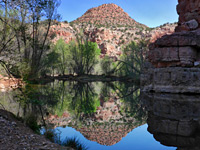
The main path at the north end of Sycamore Canyon is the Sycamore Rim Trail, an 11 mile loop along the north rim of the two upper forks, the circuit completed by a crossing of wooded land and ascent of a small hill. The west fork itself splits into two short branches, each starting abruptly via sheer cliffs, down which cascade spectacular waterfalls after rainfall or during the snowmelt season, and retain water all year in deep pools (frozen solid for several months during the winter) at the base; both are known collectively as Sycamore Falls. This is a relatively popular location, though most people come only to look at the falls, or to practice rock climbing down the adjacent cliffs, or perhaps walk 2 miles to an overlook of the canyon confluence; the full loop is rarely hiked. Instead, the only popular path in the canyon is the Parsons Trail at the far southern end (95 miles distant by road); a 4 mile route that follows a permanent stream through dense, riparian vegetation to the source of the water at a series of large springs. Most other recognized hiking routes are very remote, some crossing the exposed, uneven terrain around the southern half of the gorge, others along parts of the rim to the north, and a few descending to the canyon floor, such as the Dogie, Taylor Cabin, Kelsey Springs and Winter Cabin trails.
Featured Hikes in Sycamore Canyon
Parsons Trail
★★★★★
★★★★★
3.7 miles, 200 feet
Mostly easy path through the wooded, riparian lower section of Sycamore Canyon, following a permanent stream that forms many deep pools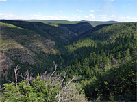
Sycamore Canyon Overlook Trail
★★★★★
★★★★★
1.8 miles, 100 feet
From the campground at White Horse Lake, this lightly used path traverses open pine woodland to a viewpoint on the rim of Sycamore Canyon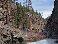
Sycamore Falls
★★★★★
★★★★★
2 miles, 400 feet (loop)
Off-trail loop to the twin canyons at the upper end of the west fork of Sycamore Canyon, also passing a crater on the rim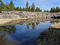
Sycamore Rim Trail
★★★★★
★★★★★
11 miles, 800 feet (loop)
Loop around the two upper forks of Sycamore Canyon; highlights include a series of basaltic pools, a wooded summit, a pair of dry waterfalls and a viewpoint high above the confluence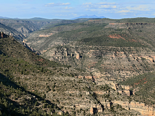
Sycamore Canyon - Nearby Places
- Kingman to Williams - atmospheric section of old Route 66
- Tuzigoot National Monument - Sinagua Indian ruin in the Verde River valley
Sycamore Canyon - Similar Places
- Agua Fria National Monument - high desert region centered on a deep river canyon
- Sedona - popular town surrounded by red rock peaks and canyons
All Contents © Copyright The American Southwest | Comments and Questions | Contribute | Affiliate Marketing Disclosure | Site Map