Highlights:
Extensive, overgrown lava flows, bearing yucca, cacti and other desert plants. Park has a good campground with elevated views, and a short nature trail
Nearby town:
Ruidoso, 36 miles
Management:
Location:
Seasons:
All year
Rating (1-5):
★★★★★

Valley of Fires is part of the New Mexico Highlights itinerary
The Valley of Fires Recreation Area in central New Mexico is an interesting diversion on the long, sometimes tedious cross-state journey on US 54 - from El Paso to Santa Rosa on I-40 is 270 miles, along a route which passes much barren scenery of grassy prairie, stark mountains and sandy desert.
This part of the long Tularosa Valley contains many square miles of buckled, twisted basalt lava, part of an extensive flow up to 165 feet thick and over 45 miles long that originated from several nearby volcanoes, including one vent now known as Little Black Peak, 9 miles northwest of the dusty, windswept town of Carrizozo.
The lava is called the Malpais (Spanish for 'badlands'), a name also given to several other flows in New Mexico, including the even larger deposits of the El Malpais National Monument near Grants, 130 miles northwest.
Valley of Fires Table of Contents


Photographs
21 views of the Valley of Fires.
Lava
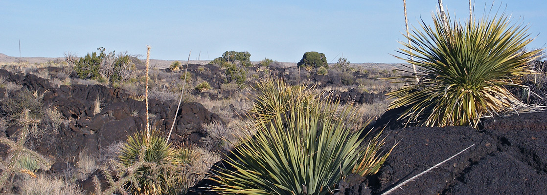
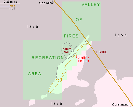
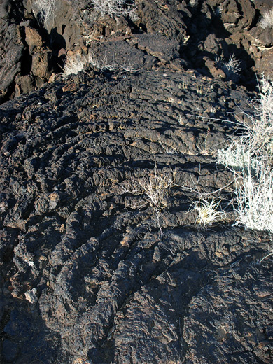
The Valley of Fires lava fields are reached by driving 4 miles northwest along US 380 from the junction with US 54 at Carrizozo. A short side road ends at a BLM-managed campsite, on a ridge of Dakota sandstone which overlooks a large expanse of lava, extending to low hills over 10 miles away on the hazy horizon. The ridge is a small remnant of the land before the eruption, just high enough to remain uncovered. The volcanic action responsible was relatively recent, occurring between 1,500 and 5,000 years ago, but the lava has become quite overgrown with grass and small bushes so the landscape is generally greenish in color rather than black, less of a dramatic spectacle than other Southwest deposits such as Sunset Crater in Arizona or the Fantastic Lava Beds in Lassen Volcanic National Park, California. It is however quite well preserved, with interesting geological features including lava caves, pressure ridges, collapsed gas bubbles and two types of lava - rough blocks of aa and ropy flows of pahoehoe. Plant life is typical of the northern Chihuahuan Desert; common species include banana yucca, sotol, echinocereus, opuntia, cane cholla, mesquite, sumac and creosote bushes.


Valley of Fires Facilities
The campsite has 19 sites, all equipped with tables, grills, drinking water and metal shelters, and some with electric hookups. Views are good but the place is quite exposed, so is often very windy, and hot in summer; most people visit in spring and fall. Apart from a partly paved, 3/4 mile nature loop trail on the west wide of the campground, and an unmaintained path at the south end of the ridge, opportunities to explore the surroundings are somewhat limited as the surface is sharp and unstable, but off-trail hiking is quite possible with care. Day use fees start at $3 (in 2024) for a vehicle with one person, avoidable by parking along the highway just outside the entrance and walking directly into the lava - but then all other parts of the vast lava field, away from the small recreation area, are also free to explore. The southern edge of the black formations is only 14 miles from the start of the dazzling white dunes of the White Sands National Park, just one of many striking contrasts in the state of New Mexico.
Valley of Fires - Nearby Places
- Bosque del Apache National Wildlife Refuge (68 miles) - scenic wetlands with abundant birds and aquatic life
- Salinas Pueblo Missions National Monument (61 miles to Gran Quivira) - Spanish churches and ruined pueblos
Valley of Fires - Similar Places
- El Malpais National Monument, New Mexico - many square miles of black, twisted lava and other volcanic formations
- Fantastic Lava Beds, Lassen Volcanic National Park, California - jumbled lava blocks, next to a cinder cone
- Sunset Crater Volcano National Monument, Arizona - large expanses of lava and ash, with colorful cinder cones
All Contents © Copyright The American Southwest | Comments and Questions | Contribute | Affiliate Marketing Disclosure | Site Map