| NEVADA | Index | Maps | Driving Distances | Introduction | National Parks | Weather | Photographs | QTVR | Hotels | |||||||||
Nevada - Map | ||||||||||
Sites in Nevada Nevada Parks Cathedral Gorge Great Basin Lake Tahoe Nevada Red Rock Canyon Valley of Fire Other Places Ash Meadows Black Rock Desert Las Vegas Lunar Crater Mount Charleston Pyramid Lake Scenic Drives Whitney Pockets Nevada Site Map Site Search Photograph Search |
Overview Map of the Southwest Other state maps: Arizona, California (North), California (South and Central), Colorado, New Mexico, Oregon, Utah, Texas, Wyoming 
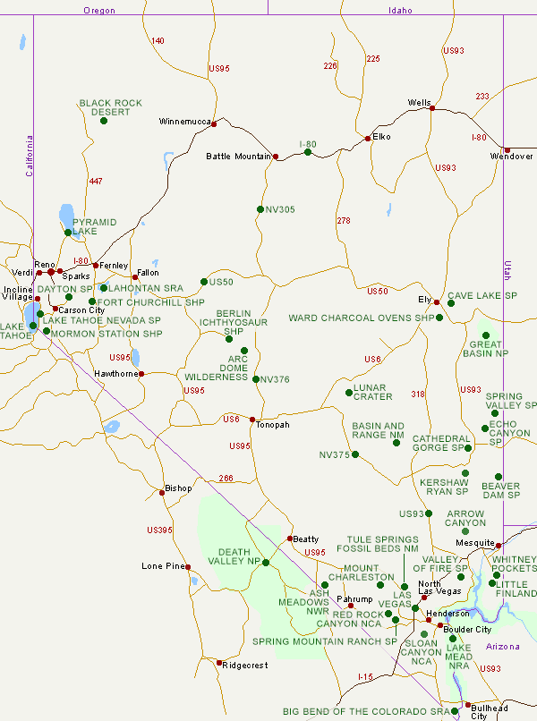
Click on the green circles on the Nevada state map for descriptions and photographs of parks and other scenic areas. Descriptions of Lake Mead and the Hoover Dam are given in the Arizona Guide, while details on Lake Tahoe and Death Valley are in the California Guide. Delorme Nevada Atlas: The Nevada atlas from the Delorme topographic series covers the state at a scale of 1:250,000 or 1 inch to 4 miles, resulting in 55 individual maps, plus a more detailed street map of Las Vegas. Contour lines are given at 200 foot intervals, and every road in the state down to the roughest 4WD track is clearly depicted. Other sections include an index of all named features on the maps, and pages about unique natural features (24 of them), historic sites, scenic drives, casinos, hunting zones, hiking trails and fishing locations.Buy from amazon.com | |||||||||
| Back to Top | ||||||||||
Arizona | California | Colorado | Nevada | New Mexico | Oregon | Texas | Utah | Wyoming | Slot Canyons | Travelogue | SOUTHWEST |
||||||||||