Catstair Canyon, Grand Staircase-Escalante National Monument
Utah > Grand Staircase-Escalante National Monument > Catstair Canyon
Catstair Canyon
Short, red rock canyon through the Cockscomb, alongside US 89; narrows, dryfalls, and a stack of 1950s cars
Length: 1 mile, between the 2 trailheads, or a 1.7 mile loop
Elevation change: 210 feet
Difficulty: Moderate; an optional rappel, and scrambling to bypass obstacles
Type: One way, off trail; or a loop, returning along the highway
Usage: Low
Season: All year
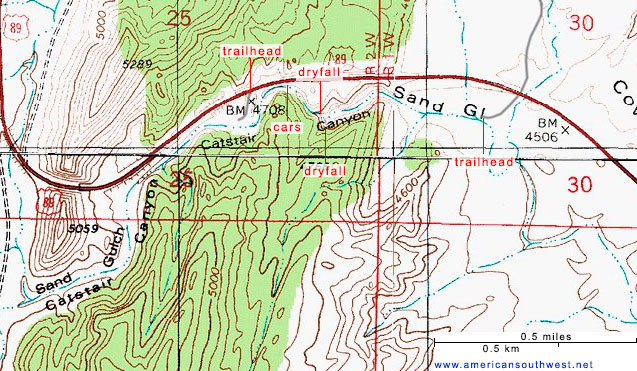
Trailheads: Two pullouts along US 89, west of the Paria River: upper, lower
Rating (1-5): ★★★★★
Elevation change: 210 feet
Difficulty: Moderate; an optional rappel, and scrambling to bypass obstacles
Type: One way, off trail; or a loop, returning along the highway
Usage: Low
Season: All year
Trailheads: Two pullouts along US 89, west of the Paria River: upper, lower
Rating (1-5): ★★★★★

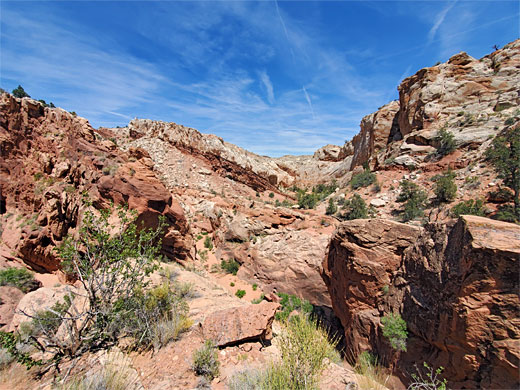
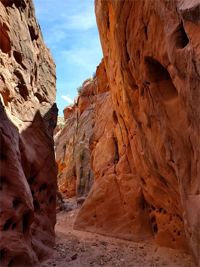
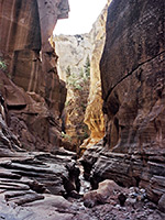
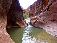
Sand Gulch in southern Utah is a usually dry drainage that originates as many little forks on the eastern slopes of Fivemile Mountain, just west of the Cockscomb, a long ridge of upturned strata. The forks combine into two main branches, flowing northwards and southwards along the base of the Cockscomb, then after joining, the combined drainage cuts right through the ridge forming a 1.4 mile enclosed section named Catstair Canyon, so-designated because it descends in a series of vertical steps and narrow channels, and it was thought that only a cat could navigate the passageways. East of the Cockscomb, the drainage continues four miles over open, sandy terrain, and meets the Paria River near the Paria Ranger Station.
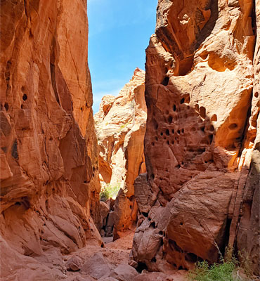
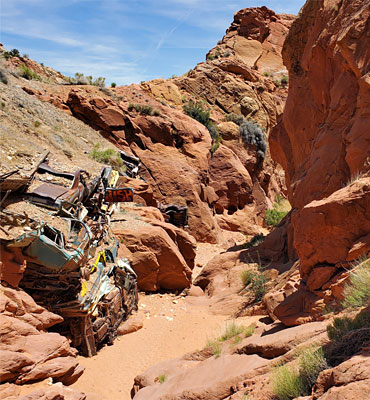
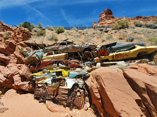
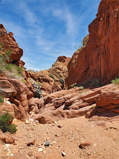
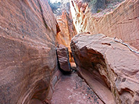
The lower half of Catstair Canyon is the most scenic since it has the highest cliffs, the best narrows, and several dryfalls, plus the incidental attraction of a stack of flattened cars from the 1950s, installed as part of an embankment when the adjacent highway (US 89) was constructed through the Cockscomb. Along the road are two (unsigned) trailheads, linked by a one-way hike of one mile, up or down the narrows; a road walk allows a loop, of 1.7 miles.
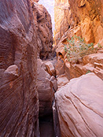
The traverse is easiest in the downstream direction, though is still quite possible upstream, as described below. Towards the lower end of the narrows are two pour-offs that require rappelling to descend, however both can be bypassed. Most people who visit the canyon see only the short (1000 foot) stretch from the upper parking place to the stacked cars, since the first significant obstacle, a boulder and dryfall, is found just downstream.
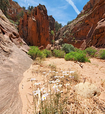
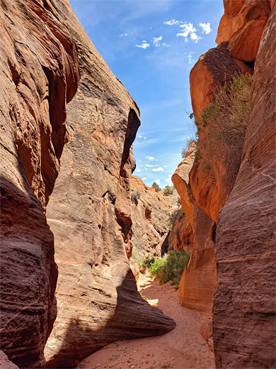
The upper (west) Catstair Canyon trailhead is right beside the highway, in the middle of the Cockscomb - a small paved area, from where a 400 foot track heads southwest to an alternative parking place, overlooking the drainage, which is shallow at this point. The lower trailhead is 0.7 miles east, again parking either at the side of the road, or along an equally short track that curves over a sandy flat down to the streambed; also a good primitive camp spot, out-of-sight of the highway.
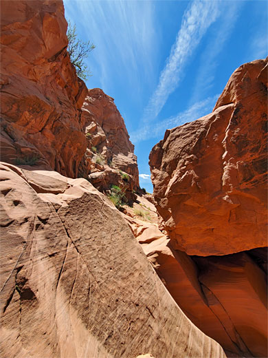
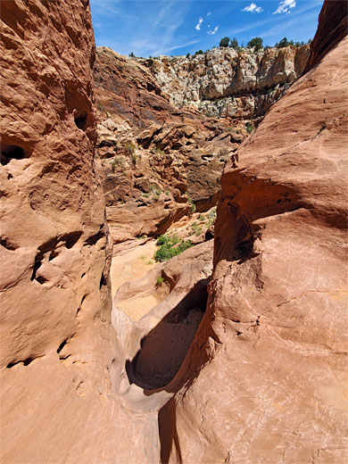
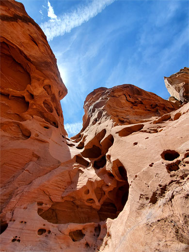
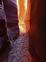
From the lower parking place at the end of the track, a narrow path crosses a tributary wash then runs through sandy, bushy land for a fifth of a mile to the lower end of the canyon, formed by inclined layers of whitish sandstone, from the Thousand Pockets Tongue member of the Carmel Formation. The ravine stays open for a while, round a big cliff then bends 90 degrees to the right, gaining height via a tall drop-off, passable by climbing the slope to the left. A short distance further is a higher, more sloping dryfall incorporating a couple of potholes, also by passed on the left, by a rather longer climb. The rocks now are a different part of the Carmel Formation (Judd Hollow Member), then after the second dryfall they change again, to Navajo sandstone, which forms the remainder of the canyon.
The next 400 feet is the deepest and narrowest part of the canyon, containing a couple of smaller dryfalls, both fairly easily climbable. After the second the canyon is much shallower and, after a short sequence of boulders, passes the stacked cars - on the north side, just 40 feet from the highway. It is easy to climb up here back to the road. Upstream, the canyon is more open, bending round a protruding fin then reaching a little path that climbs to the track from the upper parking place.
The lower half of Catstair Canyon is the most scenic since it has the highest cliffs, the best narrows, and several dryfalls, plus the incidental attraction of a stack of flattened cars from the 1950s, installed as part of an embankment when the adjacent highway (US 89) was constructed through the Cockscomb. Along the road are two (unsigned) trailheads, linked by a one-way hike of one mile, up or down the narrows; a road walk allows a loop, of 1.7 miles.
The traverse is easiest in the downstream direction, though is still quite possible upstream, as described below. Towards the lower end of the narrows are two pour-offs that require rappelling to descend, however both can be bypassed. Most people who visit the canyon see only the short (1000 foot) stretch from the upper parking place to the stacked cars, since the first significant obstacle, a boulder and dryfall, is found just downstream.
Trailheads
The upper (west) Catstair Canyon trailhead is right beside the highway, in the middle of the Cockscomb - a small paved area, from where a 400 foot track heads southwest to an alternative parking place, overlooking the drainage, which is shallow at this point. The lower trailhead is 0.7 miles east, again parking either at the side of the road, or along an equally short track that curves over a sandy flat down to the streambed; also a good primitive camp spot, out-of-sight of the highway.
Lower Catstair Canyon
From the lower parking place at the end of the track, a narrow path crosses a tributary wash then runs through sandy, bushy land for a fifth of a mile to the lower end of the canyon, formed by inclined layers of whitish sandstone, from the Thousand Pockets Tongue member of the Carmel Formation. The ravine stays open for a while, round a big cliff then bends 90 degrees to the right, gaining height via a tall drop-off, passable by climbing the slope to the left. A short distance further is a higher, more sloping dryfall incorporating a couple of potholes, also by passed on the left, by a rather longer climb. The rocks now are a different part of the Carmel Formation (Judd Hollow Member), then after the second dryfall they change again, to Navajo sandstone, which forms the remainder of the canyon.
Upper Catstair Canyon
The next 400 feet is the deepest and narrowest part of the canyon, containing a couple of smaller dryfalls, both fairly easily climbable. After the second the canyon is much shallower and, after a short sequence of boulders, passes the stacked cars - on the north side, just 40 feet from the highway. It is easy to climb up here back to the road. Upstream, the canyon is more open, bending round a protruding fin then reaching a little path that climbs to the track from the upper parking place.
Topographic Map of Catstair Canyon
Catstair Canyon - Similar Hikes
All Contents © Copyright The American Southwest | Comments and Questions | Contribute | Affiliate Marketing Disclosure | Site Map