Slot canyons in and around Capitol Reef National Park, Utah.
Capitol Reef Canyoneering Tour
Capitol Reef National Park and its main geological feature the Waterpocket Fold are less well known for slot canyons than either the San Rafael Swell to the north or the Escalante area further south, partly because the slot-forming Navajo and Wingate sandstone layers are inclined and so exposed at the surface for a relatively short distance, yet there are quite a few hidden, water-carved ravines that equal any in terms of narrowness and pretty rock formations. Along the main scenic drive south of the visitor center are two deep canyons - Grand Wash and Capitol Gorge, both of which have easy, level trails and are not particularly enclosed, but most of the official paths in the national park are to overlooks, summits or sandstone arches; the majority of the other canyons are more remote and harder to reach.
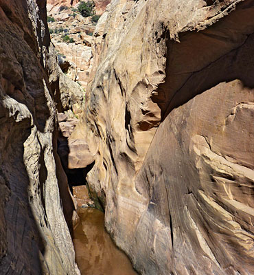
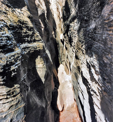
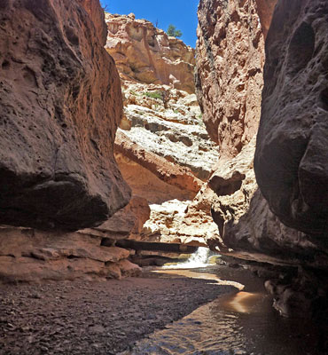
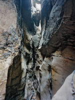
Two long, watery canyon hikes are along the Fremont River and Sulphur Creek, both on the west side of the national park, where permanent streams flow through gorges several hundred feet deep, encountering waterfalls, long pools and some narrowish sections. Most of the other interesting canyons are on the east side of the Waterpocket Fold, reached by the mostly unpaved but good quality Notom-Bullfrog Road. From Pleasant Creek, not far from Notom near UT 12, to the Millers Creek region 50 miles south, there are over two dozen narrow canyons and their tributaries cutting through the tilted strata and huge sandstone domes of the reef. They all tend to become quite narrow, often containing flooded passages and dryfalls, but the effort spent hiking into them is well rewarded by the spectacular geology and the peaceful, little-visited surroundings. Full exploration for many of the deeper canyons needs to begin at the upper (west) ends because the streambeds have one or more sheer drops that requiring rappelling, but some can be seen by walking upstream starting in the east; of the best canyons, all of Sheets Gulch, most of Burro Wash, about half of Cottonwood Wash but not much of Five Mile Wash may be seen this way.
Further south, two quite well known canyons are Muley Twist - a long drainage featuring huge alcoves and overhanging cliffs - and the narrows of Lower Halls Creek, where a seasonal stream has eroded deep into the Navajo sandstone forming quite an impressive slot section, partly flooded for much of the year. Both are accessed from Notom-Bullfrog Road, and both need a long day to explore fully. The Waterpocket Fold north of UT 24 is much less accessible so the numerous canyons here are yet to be fully explored - there are many tributaries of Deep Creek and Spring Canyon that have long or short slot sections. One place within reach of a (long) day hike is Pandora's Box, a south-side tributary of Spring Canyon north of Meeks Mesa. This has several sheer dryfalls between quite lengthy stretches of tight narrows.
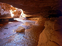
Burro Wash
★★★★★
★★★★★
4 miles, 600 feet
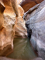
Sandy streamway leading to a watery slot; several narrow sections, some quite dark and confined, through greyish rocks of varying texturesCottonwood Wash
★★★★★
★★★★★
3 miles, 400 feet
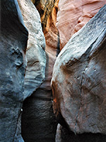
Deep, quite pretty canyon with pools and chokestones. The lower end is moderately enclosed, containing long but shallow slots, and becomes gradually more difficult to followFive Mile Wash
★★★★★
★★★★★
1.8 miles, 150 feet
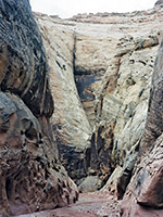
A large drainage cutting right through Capitol Reef, but one blocked near the lower end, after a very short enclosed section, by a pool and difficult-to-climb dryfall. The canyon can be followed further at rim levelGrand Wash
★★★★★
★★★★★
2.25 miles, 200 feet
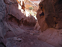
Easiest explored of Capitol Reef's narrow canyons, with an official NPS trailhead at either end; route follows a deep gorge that is around 20 feet across at its most confined pointSheets Gulch
★★★★★
★★★★★
4.7 miles, 350 feet
Lengthy drainage forming shallow but pretty slot sections through nicely colored rocks. No major obstructions. Lower narrows through Navajo sandstone give way to a wider Wingate canyon towards the west side of the reefSulphur Creek
★★★★★
★★★★★
5.3 miles, 500 feet
Although there is no trail through the deep, watery narrows of Sulphur Creek, the route is well enough known to have an NPS sign at the trailhead, shared with Chimney RockCapitol Reef Canyoneering Tour
Capitol Reef National Park and its main geological feature the Waterpocket Fold are less well known for slot canyons than either the San Rafael Swell to the north or the Escalante area further south, partly because the slot-forming Navajo and Wingate sandstone layers are inclined and so exposed at the surface for a relatively short distance, yet there are quite a few hidden, water-carved ravines that equal any in terms of narrowness and pretty rock formations. Along the main scenic drive south of the visitor center are two deep canyons - Grand Wash and Capitol Gorge, both of which have easy, level trails and are not particularly enclosed, but most of the official paths in the national park are to overlooks, summits or sandstone arches; the majority of the other canyons are more remote and harder to reach.
Further south, two quite well known canyons are Muley Twist - a long drainage featuring huge alcoves and overhanging cliffs - and the narrows of Lower Halls Creek, where a seasonal stream has eroded deep into the Navajo sandstone forming quite an impressive slot section, partly flooded for much of the year. Both are accessed from Notom-Bullfrog Road, and both need a long day to explore fully. The Waterpocket Fold north of UT 24 is much less accessible so the numerous canyons here are yet to be fully explored - there are many tributaries of Deep Creek and Spring Canyon that have long or short slot sections. One place within reach of a (long) day hike is Pandora's Box, a south-side tributary of Spring Canyon north of Meeks Mesa. This has several sheer dryfalls between quite lengthy stretches of tight narrows.
Related Sections
- Capitol Reef National Park - general information
- Capitol Reef overview map
All Contents © Copyright The American Southwest | Comments and Questions | Contribute | Affiliate Marketing Disclosure | Site Map