
Prospect Trail
The longest trail in Valley of Fire State Park, following two dry washes through amazing formations of Aztec sandstone, including arches and pinnacles; initially red, then more varied in color
Length: 4.6 miles
Elevation change: 340 feet
Difficulty: Moderate; no obstacles or steep sections, but relatively long
Type: One-way
Usage: Low
Season: Fall, winter, spring; closed between mid May and end of September, due to the heat
Trailhead: Parking place along the scenic drive near Atlatl Rock, at the junction with a disused track
Rating (1-5): ★★★★★

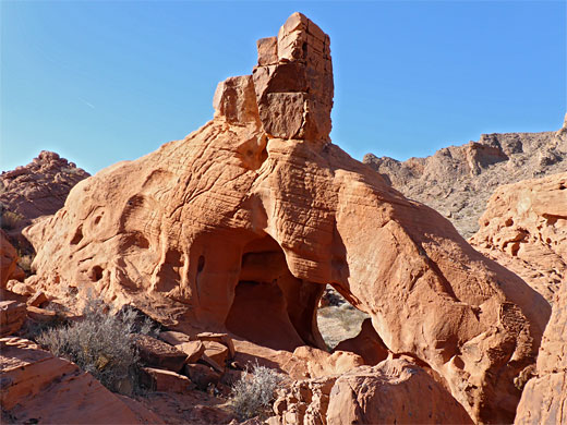
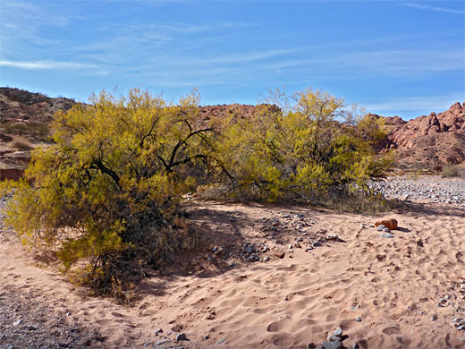
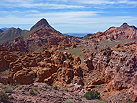
The Prospect Trail is the longest hike in Valley of Fire State Park, at 4.6 miles, running north to south between a parking place along the main road just east of Atlatl Rock, and an intersection with the White Domes Trail, half a mile from its trailhead at the north end of the scenic drive. The route is not often traveled and classed as unmaintained, yet is easy enough to follow, with little elevation change, and it passes an amazing assortment of rock colors and eroded formations, including pinnacles and arches, the rocks in some parts uniformly dark red, in others lighter, more pastel - shades of pink, yellow, purple and orange.
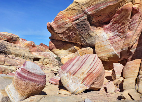
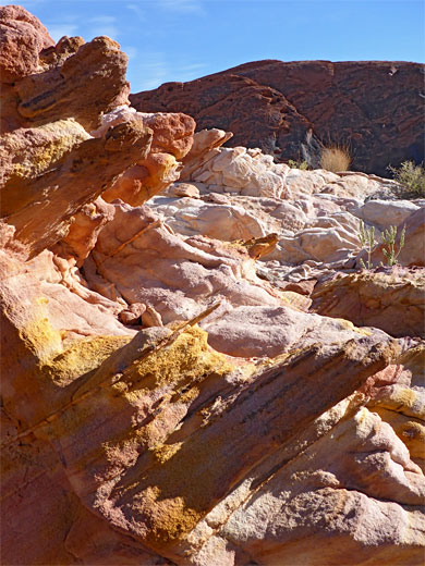
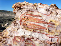
All the bedrock is Aztec sandstone, found across most of the park; the red is from the upper unit of the sandstone, which overlies the more varied lower unit, where its composition is modified and the colors enhanced by presence of iron compounds.
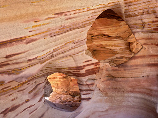
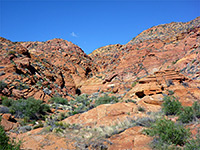
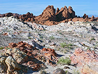
The trail is bordered by high cliffs to the east while to the west the land is more open, the views extending beyond the edge of the sandstone outcrops to a more typical desert landscape of bushy plains and low summits. The lighter-colored sandstone areas in particular are worthy of off-trail exploration as there are innumerable pretty formations, formed of bands of the contrasting colors.
Like nearly all paths in the park, the Prospect Trail is closed in summer, from the middle of May to the start of October, because the heat is deemed too extreme - sometimes exceeding 110 °F.
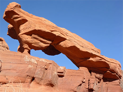
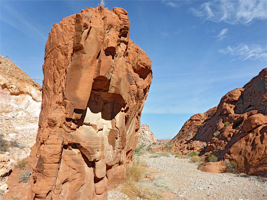
The Prospect Trail once began at the end of a short track, but this has been closed to public vehicles, so instead parking is along the main road, 0.4 miles east of the turning for Atlatl Rock. A sign states that the path is neither maintained nor marked, though this at least is not true as the route is clearly identified at intervals by white and yellow posts. The old track heads north for nearly half a mile then veers away to a service building; the trail continues north at the bend, across a few minor drainages and the larger Valley of Fire Wash, then rises gently towards the mouth of a short valley, framed by cliffs of dark red sandstone to the east and a duller-colored sandstone ridge to the west. Small red outcrops become more numerous as the trail ascends to a divide just before which, to the west, is a fine, freestanding arch, photogenic from all angles.
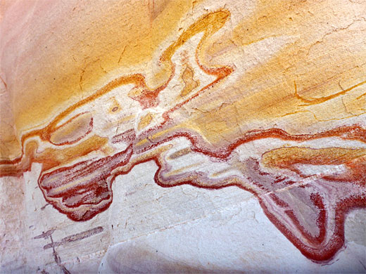
The trail crests the saddle, and the land opens up, affording more wide-ranging views; the route moves temporarily away from the red rocks, close to the first patch of lighter sandstone. It takes a further westwards diversion to avoid a minor drop-off in a tributary wash, then returns to a larger drainage, which is followed for 1.8 miles, to the confluence with Kaolin Wash, close to the White Domes Trail. Shortly after joining this northwards drainage, the rocks to the west change from red to the lighter colors; the best section of the hike. A little slot-like tributary leads to a good area of stripy formations, as does a second shortly after, also to the west. Rocks hereabouts are variously colored uniform pale yellow, striped pink and yellow, or striped deep orange and purple.
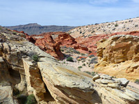
After a less interesting area is an even larger band of the most colorful formations, crossed by little gullies, before the rocks to the west change back to red. A larger tributary is followed by a dryfall, easily climbable, though the path moves to the west to avoid it - up a little ravine and back down just below the fall. The wash becomes wider, the floor flat and stony, passing one more narrow tributary, on the west side, and on to the junction with Kaolin Wash, which meets the White Domes Trail half a mile east. A notice at this junction gives the Prospect Trail distance as 5.5 miles, though 4.6 miles seems more accurate.
All the bedrock is Aztec sandstone, found across most of the park; the red is from the upper unit of the sandstone, which overlies the more varied lower unit, where its composition is modified and the colors enhanced by presence of iron compounds.
The trail is bordered by high cliffs to the east while to the west the land is more open, the views extending beyond the edge of the sandstone outcrops to a more typical desert landscape of bushy plains and low summits. The lighter-colored sandstone areas in particular are worthy of off-trail exploration as there are innumerable pretty formations, formed of bands of the contrasting colors.
Like nearly all paths in the park, the Prospect Trail is closed in summer, from the middle of May to the start of October, because the heat is deemed too extreme - sometimes exceeding 110 °F.
Red Sandstone
The Prospect Trail once began at the end of a short track, but this has been closed to public vehicles, so instead parking is along the main road, 0.4 miles east of the turning for Atlatl Rock. A sign states that the path is neither maintained nor marked, though this at least is not true as the route is clearly identified at intervals by white and yellow posts. The old track heads north for nearly half a mile then veers away to a service building; the trail continues north at the bend, across a few minor drainages and the larger Valley of Fire Wash, then rises gently towards the mouth of a short valley, framed by cliffs of dark red sandstone to the east and a duller-colored sandstone ridge to the west. Small red outcrops become more numerous as the trail ascends to a divide just before which, to the west, is a fine, freestanding arch, photogenic from all angles.
Multicolored Sandstone
The trail crests the saddle, and the land opens up, affording more wide-ranging views; the route moves temporarily away from the red rocks, close to the first patch of lighter sandstone. It takes a further westwards diversion to avoid a minor drop-off in a tributary wash, then returns to a larger drainage, which is followed for 1.8 miles, to the confluence with Kaolin Wash, close to the White Domes Trail. Shortly after joining this northwards drainage, the rocks to the west change from red to the lighter colors; the best section of the hike. A little slot-like tributary leads to a good area of stripy formations, as does a second shortly after, also to the west. Rocks hereabouts are variously colored uniform pale yellow, striped pink and yellow, or striped deep orange and purple.
Kaolin Wash
After a less interesting area is an even larger band of the most colorful formations, crossed by little gullies, before the rocks to the west change back to red. A larger tributary is followed by a dryfall, easily climbable, though the path moves to the west to avoid it - up a little ravine and back down just below the fall. The wash becomes wider, the floor flat and stony, passing one more narrow tributary, on the west side, and on to the junction with Kaolin Wash, which meets the White Domes Trail half a mile east. A notice at this junction gives the Prospect Trail distance as 5.5 miles, though 4.6 miles seems more accurate.

Prospect Trail - Similar Hikes
All Contents © Copyright The American Southwest | Comments and Questions | Contribute | Affiliate Marketing Disclosure | Site Map