Petroglyph Canyon Trail, Sloan Canyon National Conservation Area
Nevada > Sloan Canyon National Conservation Area > Petroglyph Canyon Trail
Petroglyph Canyon Trail
Path to the main rock art location in Sloan Canyon NCA, in a rocky ravine in the McCullough Mountains; over a few minor dryfalls but mostly along a stony streambed, returning via a partial loop down an adjacent ravine
Length: 4.1 miles
Elevation change: 500 feet
Difficulty: Easy to moderate
Type: Partial loop
Usage: Medium
Season: Fall, winter, spring
Trailhead: South end of Nawghaw Poa Road
Rating (1-5): ★★★★★
Elevation change: 500 feet
Difficulty: Easy to moderate
Type: Partial loop
Usage: Medium
Season: Fall, winter, spring
Trailhead: South end of Nawghaw Poa Road
Rating (1-5): ★★★★★

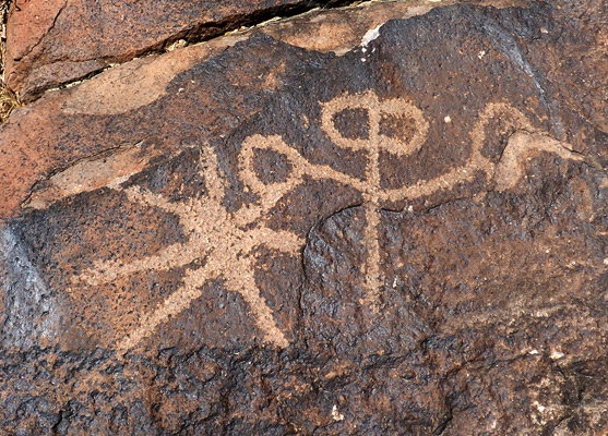
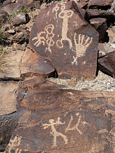
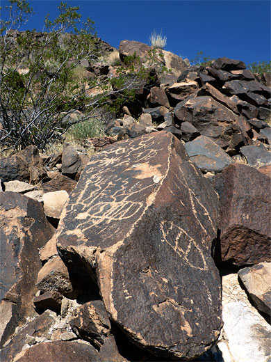
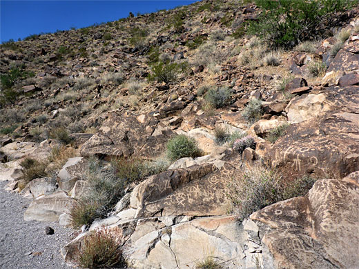
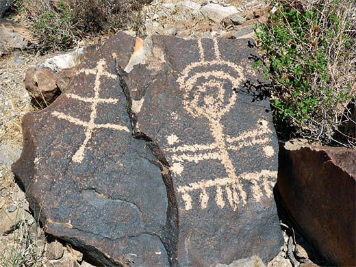
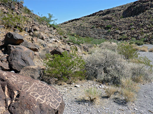
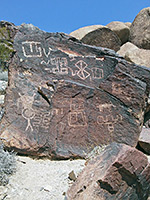
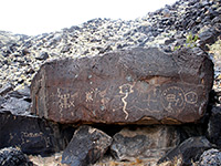
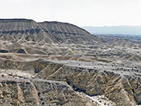
A network of paths cross the northern reaches of the McCullough Range in Sloan Canyon National Conservation Area near Las Vegas, climbing to ridges and peaks, but by far the most well-known hike in the preserve is the Petroglyph Canyon Trail, which follows a shallow ravine through the western section of the mountains to one of the most important archaeological sites in Nevada, with over 300 separate rock art panels and around 1,700 individual designs. The majority of the petroglyphs are concentrated along a 500 foot stretch of the canyon, on both sides, and they cover several thousand years of history, from the Archaic peoples to 19th-century settlers.
The petroglyphs are etched into the weathered patina of the dark volcanic boulders which are scattered all over the mountains, and many of the designs are large, clear and easy to locate. The figures mark an ancient cross-country route across the mountains - up the canyon, over a divide and down another drainage to the south, though the importance of this particular location is unclear. The rock art has a great variety of designs, including anthropomorphic figures, animals, hunt scenes and geometric shapes.
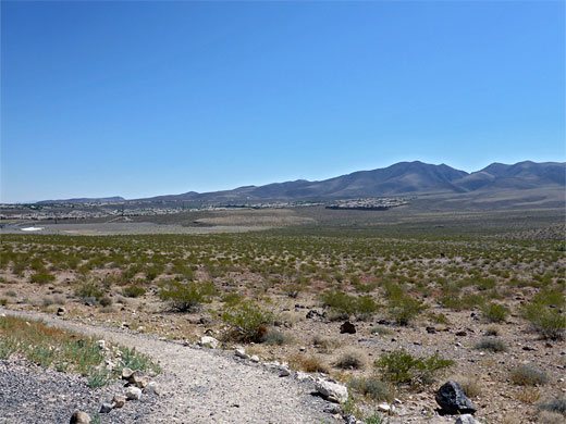
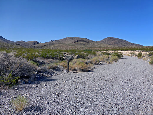
The Petroglyph Canyon trailhead, previously reached only by a gravel track, has recently been upgraded, and the access road paved, as part of the ever-expanding suburbs of Henderson, now reaching right to the NCA boundary half a mile away, currently just northeast of the trailhead, and extending westwards over the next few years. The final part of the approach is along Nawghaw Poa Road, named after the Paiute phrase for 'Mountain Sheep Trail'. This location is 7 miles from St Rose Parkway, along Executive Airport Drive and Via Inspirada. The contact station is staffed all week from fall to spring and at weekends in summer, when the high temperatures, 110°F or more, discourage most hikers.
The contact station building, a trailer, is soon to be replaced with a permanent structure. Free bottled drinking water is provided, plus a trail map, and advice about the hike, which is relatively easy, apart perhaps from the heat, but does require climbing a couple of minor dryfalls. These obstructions can if desired be avoided by a slightly longer and steeper bypass route up a neighboring ravine (trail 200), but for most people, the usual plan is to approach by the main canyon (trail 100) and return by the other route, a partial loop of 4.1 miles, gaining 500 feet.
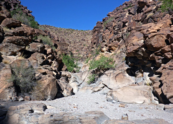
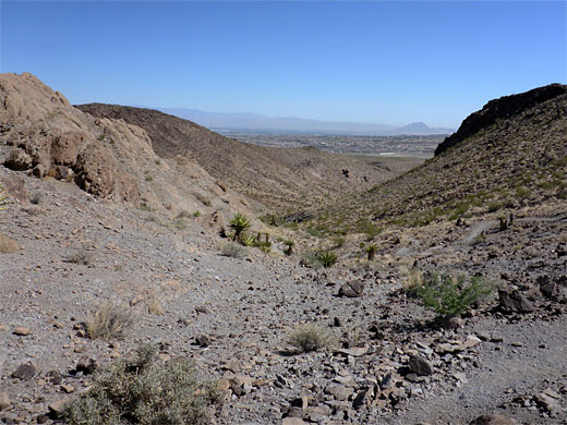
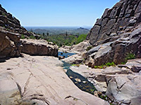
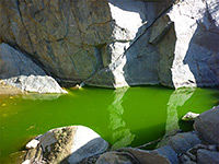
The parking lot is high enough for good views all across Las Vegas towards the distant Spring Mountains, though the immediate surroundings are a rather featureless plain, with the McCullough Mountains rising to the east and south. The start of the trail will shortly be rerouted; it currently heads east, descending to the dry wash from Petroglyph Canyon, and following this upstream, to the south. The wash stays open for while, and straight, up to a fence and post at the edge of the North McCullough Wilderness, then winds through a few minor bends while becoming gradually more enclosed. Cliffs rise up, highest on the east side, and the sheltered surroundings only serve to increase the heat, the sunlight reflected off the dark, often shiny rock surfaces at either side. A sign marks the junction with the bypass route to the west, trail 200, soon after which is a ledge creating a pour-off, quite easy to climb. After another thousand feet, the canyon curves to the west and enters its narrowest section, framed by colorful walls, containing a second small dryfall beside which are some faded petroglyphs. Another bend, soon after, is followed by a wider section of the drainage, the main petroglyph location; there are hundreds of designs on large and small boulders, extending from stream level to 100 feet or more up the slopes. A few designs are split into two sections, the boulder having cracked over the centuries since they were created.
The rock art gradually becomes less widespread as the drainage slowly gains height, then bends to the southwest, past one tributary and on to another, on the north side. The confluence marks the upper end of trail 100, and also of trail 200, used as the return route, up the tributary. Another trail (300), continues south for 2.6 miles, over a saddle and down a wide alluvial plain to the remote Hidden Valley trailhead, on the far side of the mountains. The completely undeveloped valley beyond, centered on a dry lake bed, is under threat from future housing developments. Trail 200 climbs up the tributary ravine to a divide that gives grand views of the mountains then descends another, similarly-sized valley back to the initial junction.
The petroglyphs are etched into the weathered patina of the dark volcanic boulders which are scattered all over the mountains, and many of the designs are large, clear and easy to locate. The figures mark an ancient cross-country route across the mountains - up the canyon, over a divide and down another drainage to the south, though the importance of this particular location is unclear. The rock art has a great variety of designs, including anthropomorphic figures, animals, hunt scenes and geometric shapes.

Location
The Petroglyph Canyon trailhead, previously reached only by a gravel track, has recently been upgraded, and the access road paved, as part of the ever-expanding suburbs of Henderson, now reaching right to the NCA boundary half a mile away, currently just northeast of the trailhead, and extending westwards over the next few years. The final part of the approach is along Nawghaw Poa Road, named after the Paiute phrase for 'Mountain Sheep Trail'. This location is 7 miles from St Rose Parkway, along Executive Airport Drive and Via Inspirada. The contact station is staffed all week from fall to spring and at weekends in summer, when the high temperatures, 110°F or more, discourage most hikers.
Contact Station
The contact station building, a trailer, is soon to be replaced with a permanent structure. Free bottled drinking water is provided, plus a trail map, and advice about the hike, which is relatively easy, apart perhaps from the heat, but does require climbing a couple of minor dryfalls. These obstructions can if desired be avoided by a slightly longer and steeper bypass route up a neighboring ravine (trail 200), but for most people, the usual plan is to approach by the main canyon (trail 100) and return by the other route, a partial loop of 4.1 miles, gaining 500 feet.
Trail to the Petroglyphs
The parking lot is high enough for good views all across Las Vegas towards the distant Spring Mountains, though the immediate surroundings are a rather featureless plain, with the McCullough Mountains rising to the east and south. The start of the trail will shortly be rerouted; it currently heads east, descending to the dry wash from Petroglyph Canyon, and following this upstream, to the south. The wash stays open for while, and straight, up to a fence and post at the edge of the North McCullough Wilderness, then winds through a few minor bends while becoming gradually more enclosed. Cliffs rise up, highest on the east side, and the sheltered surroundings only serve to increase the heat, the sunlight reflected off the dark, often shiny rock surfaces at either side. A sign marks the junction with the bypass route to the west, trail 200, soon after which is a ledge creating a pour-off, quite easy to climb. After another thousand feet, the canyon curves to the west and enters its narrowest section, framed by colorful walls, containing a second small dryfall beside which are some faded petroglyphs. Another bend, soon after, is followed by a wider section of the drainage, the main petroglyph location; there are hundreds of designs on large and small boulders, extending from stream level to 100 feet or more up the slopes. A few designs are split into two sections, the boulder having cracked over the centuries since they were created.
Return Route
The rock art gradually becomes less widespread as the drainage slowly gains height, then bends to the southwest, past one tributary and on to another, on the north side. The confluence marks the upper end of trail 100, and also of trail 200, used as the return route, up the tributary. Another trail (300), continues south for 2.6 miles, over a saddle and down a wide alluvial plain to the remote Hidden Valley trailhead, on the far side of the mountains. The completely undeveloped valley beyond, centered on a dry lake bed, is under threat from future housing developments. Trail 200 climbs up the tributary ravine to a divide that gives grand views of the mountains then descends another, similarly-sized valley back to the initial junction.
Petroglyph Canyon - Similar Hikes
All Contents © Copyright The American Southwest | Comments and Questions | Contribute | Affiliate Marketing Disclosure | Site Map