Bristlecone Loop Trail
Traverse of forested slopes, partly along an old road, past many ancient bristlecone pines in the higher elevations, with pine and aspen lower down. Long-distance views for most of the way

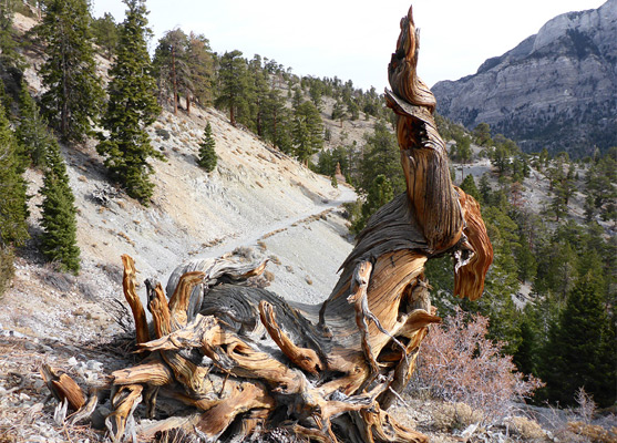
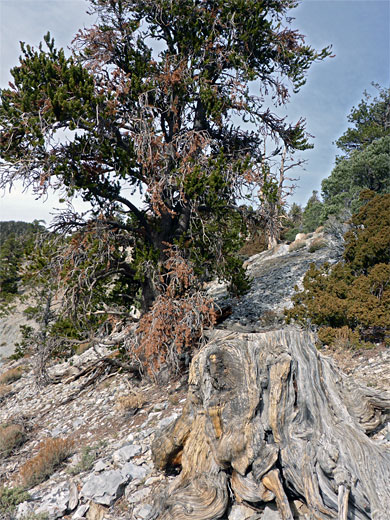
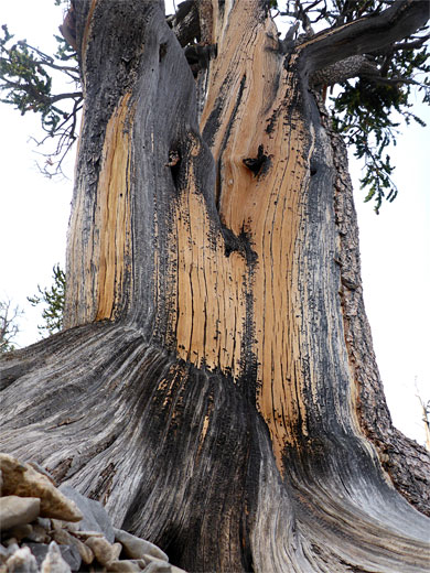
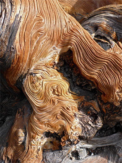
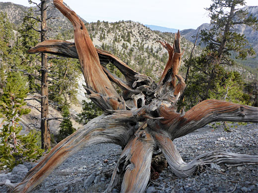
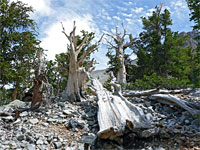
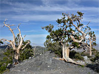
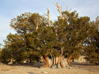
The Bristlecone Loop Trail is amongst the best of the day hikes on Mount Charleston since it has grand views most of the way, encounters varied habitats, from shady, moist woodland to open stony slopes, so is good for wildflowers, and is just long enough (6 miles, gaining 920 feet) to provide a moderate challenge. The main attractions though are several groves of Great Basin bristlecone pine (pinus longaeva) - the longest-lived trees on earth, these are widespread along the higher reaches of the trail and display the characteristic rich red-brown colors, intricate textures, and extravagantly twisted roots and branches. Some grow right beside the path while many more can be seen by walking a short distance away.
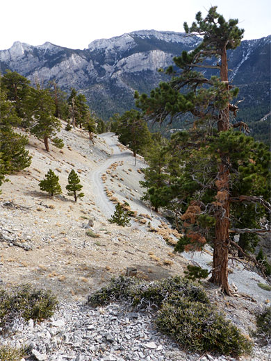
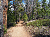
Away from the bristlecone pines, most of the trees are ponderosa pine and white fir, plus scattered limber pine and several patches of quaking aspen in the more sheltered areas; two canyons, along the north and south portions of the loop. The trail climbs these ravines then traverses the exposed, south- and east-facing slopes above, location of the bristlecones. The northern half of the hike is along an old forest road, the remainder on a regular trail, and all is well maintained and easy to follow. The route is usually snow-free for around nine months of the year.
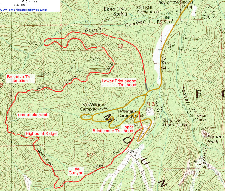
The Lower Bristlecone trailhead along Lee Canyon Road is reached by a very short gravel track, leading to a large parking area before a gate; the track continues, closed to vehicles, and forms the first part of the hike. The Upper Bristlecone trailhead is 0.9 miles further and 230 feet higher (at 8,680 feet), though the distance between is reduced to 0.4 miles if using an unofficial shortcut, bypassing two bends. Also at the end of the road are two campgrounds, a youth camp, a ski area and various administration buildings; the place is often busy during the snow season and in midsummer but much quieter in fall and early spring. Starting from the lower trailhead is preferred, and walking anticlockwise, since then most of the elevation gain is along the old track, which has gentle grades.
From the lower trailhead, the hike is along the old road (FR 71) up through stony surrounds, soon crossing the slope on the south side of a deep valley, Scout Canyon, ascending only gently, gradually coming closer to the floor of the ravine as the drainage gains height more steeply. After 1.1 miles the track passes through a gap and meets another old road, FR 204A, which follows the streambed, then bends sharply back east, looping round a grove of aspen, and continuing to rise, still through regular pine woodland, across north-facing slopes. At 1.9 miles the path crosses a divide, rounds another corner and curves west, now over south-facing terrain, the environment much more open, and soon encounters the first patch of bristlecone pines. The most photogenic specimens are above the track, both live and dead, and they extend nearly a mile, up to a junction (2.9 miles), with the Bonanza Trail, which climbs higher into the mountains.
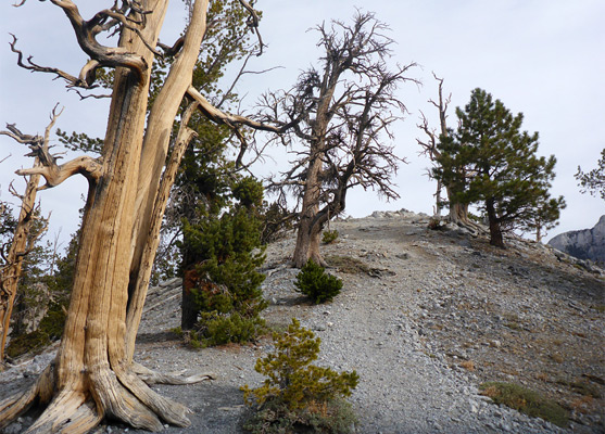
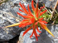
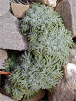
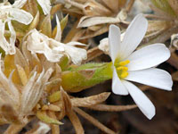
The old road ends a short distance west of the Bonanza junction, seemingly randomly, not near any particular destination; in fact it was intended to continue, over a saddle, down Wallace Canyon on the far side of the mountains, and eventually reach Pahrump, but construction was cancelled due to outbreak of WW2. The trail continues, through a rocky section and below an open slope with more bristlecone pines and then, after a brief descent, out to a bigger exposed area, Highpoint Ridge, also covered in bristlecone pines, here maybe not quite as colorful as those in the other groves. A spur path leads to a viewpoint atop a rocky knoll, 9,350 feet. To the south, the path stays level for a while then drops down to the upper end of a cool sheltered valley (Lee Canyon), the most likely place for snow to linger, whereupon it follows the usually dry streambed through pine, fir and aspen. A connector forks south to the ski center, after which is a 0.3 mile fenced-off section, before arriving at the upper trailhead. Fencing was installed in 2007 to perfect several rare wildflower species (and the Mount Charleston blue butterfly which feeds on them) that inhabit stony ground, including Charleston beardtongue, Torrey's milkvetch, Clokey's fleabane, Lemmon bitterweed, mountain oxytrope and broadkeel milkvetch. The short-cut route to the lower trailhead is down a short, steep slope to bypass a long bend along the road then through woods to cut-off a shorter bend.
Away from the bristlecone pines, most of the trees are ponderosa pine and white fir, plus scattered limber pine and several patches of quaking aspen in the more sheltered areas; two canyons, along the north and south portions of the loop. The trail climbs these ravines then traverses the exposed, south- and east-facing slopes above, location of the bristlecones. The northern half of the hike is along an old forest road, the remainder on a regular trail, and all is well maintained and easy to follow. The route is usually snow-free for around nine months of the year.
Bristlecone Loop Trailheads
The Lower Bristlecone trailhead along Lee Canyon Road is reached by a very short gravel track, leading to a large parking area before a gate; the track continues, closed to vehicles, and forms the first part of the hike. The Upper Bristlecone trailhead is 0.9 miles further and 230 feet higher (at 8,680 feet), though the distance between is reduced to 0.4 miles if using an unofficial shortcut, bypassing two bends. Also at the end of the road are two campgrounds, a youth camp, a ski area and various administration buildings; the place is often busy during the snow season and in midsummer but much quieter in fall and early spring. Starting from the lower trailhead is preferred, and walking anticlockwise, since then most of the elevation gain is along the old track, which has gentle grades.
Lower Trailhead to the Bonanza Trail Junction
From the lower trailhead, the hike is along the old road (FR 71) up through stony surrounds, soon crossing the slope on the south side of a deep valley, Scout Canyon, ascending only gently, gradually coming closer to the floor of the ravine as the drainage gains height more steeply. After 1.1 miles the track passes through a gap and meets another old road, FR 204A, which follows the streambed, then bends sharply back east, looping round a grove of aspen, and continuing to rise, still through regular pine woodland, across north-facing slopes. At 1.9 miles the path crosses a divide, rounds another corner and curves west, now over south-facing terrain, the environment much more open, and soon encounters the first patch of bristlecone pines. The most photogenic specimens are above the track, both live and dead, and they extend nearly a mile, up to a junction (2.9 miles), with the Bonanza Trail, which climbs higher into the mountains.
Bonanza Trail Junction to the Upper Trailhead
The old road ends a short distance west of the Bonanza junction, seemingly randomly, not near any particular destination; in fact it was intended to continue, over a saddle, down Wallace Canyon on the far side of the mountains, and eventually reach Pahrump, but construction was cancelled due to outbreak of WW2. The trail continues, through a rocky section and below an open slope with more bristlecone pines and then, after a brief descent, out to a bigger exposed area, Highpoint Ridge, also covered in bristlecone pines, here maybe not quite as colorful as those in the other groves. A spur path leads to a viewpoint atop a rocky knoll, 9,350 feet. To the south, the path stays level for a while then drops down to the upper end of a cool sheltered valley (Lee Canyon), the most likely place for snow to linger, whereupon it follows the usually dry streambed through pine, fir and aspen. A connector forks south to the ski center, after which is a 0.3 mile fenced-off section, before arriving at the upper trailhead. Fencing was installed in 2007 to perfect several rare wildflower species (and the Mount Charleston blue butterfly which feeds on them) that inhabit stony ground, including Charleston beardtongue, Torrey's milkvetch, Clokey's fleabane, Lemmon bitterweed, mountain oxytrope and broadkeel milkvetch. The short-cut route to the lower trailhead is down a short, steep slope to bypass a long bend along the road then through woods to cut-off a shorter bend.

Topographic Map
Bristlecone Loop Trail - Similar Hikes
All Contents © Copyright The American Southwest | Comments and Questions | Contribute | Affiliate Marketing Disclosure | Site Map