Tamarack Creek Trail and Devils Dance Floor, Yosemite National Park
California > Yosemite National Park > Tuolumne Meadows > Hiking > Tamarack Creek Trail and Devils Dance Floor
Tamarack Creek Trail and Devils Dance Floor
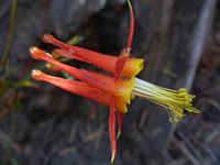
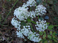
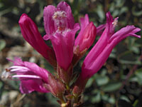
A lightly-used trail follows the shallow, partially wooded valley of Tamarack Creek, with many wildflowers in the summer, to the Tamarack Flat Campground, from where an off-trail continuation climbs to a treeless granite dome, for views of Yosemite Valley
Length: 3.7 miles
Elevation change: 500 feet
Difficulty: Easy to the camp; moderate to the dome
Type: One way path then off-trail route
Usage: Low
Season: Late spring, summer and fall
Trailhead: Pullout along Tioga Road, 6 miles east of the Crane Flat junction
Rating (1-5): ★★★★★
Elevation change: 500 feet
Difficulty: Easy to the camp; moderate to the dome
Type: One way path then off-trail route
Usage: Low
Season: Late spring, summer and fall
Trailhead: Pullout along Tioga Road, 6 miles east of the Crane Flat junction
Rating (1-5): ★★★★★

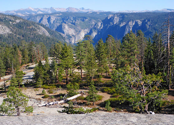
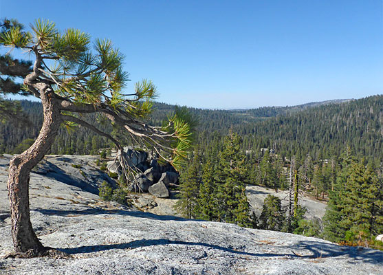
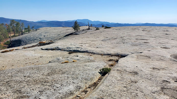
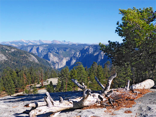
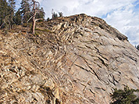
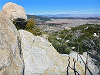
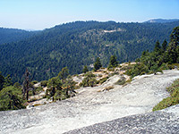
Devils Dance Floor, or Dance Hall, is a treeless granite dome, elevation 6,836 feet, a little way north of the lower end of Yosemite Valley in Yosemite National Park, much less dramatic than bigger peaks to the east like North Dome and Half Dome but still quite impressive, an island of slickrock rising above the surrounding dense pinewoods, affording grand views over the valley.
There is no trail to the dome though it can be reached relatively easily, by a cross-country walk of just less than one mile, starting from Tamarack Flat Campground, at the end of a narrow, winding, 2.5 mile unpaved track off Tioga Road. The track is however only open to vehicles when the camp is open, typically from June to October, and while at other times the camp could still be accessed on foot by this route, a more interesting and scenic option is to use the Tamarack Creek Trail, 2.6 miles, which also links the camp with Tioga Road, descending into a shallow, partly wooded valley and following a small stream southwards, through a pleasant mix of floral grassland, granite outcrops and patches of trees; worthwhile on its own as well as a route to the Devils Dance Floor.
The total distance to the Dance Floor by this route is 3.7 miles, descending 470 feet down the valley and climbing 500 feet to the dome. The path is little-used, and certainly when the campground is closed there is not likely to be anyone else in this area.
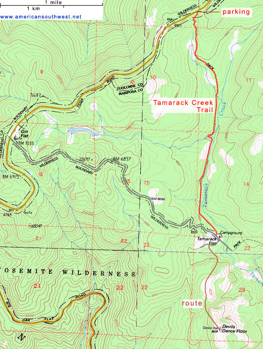
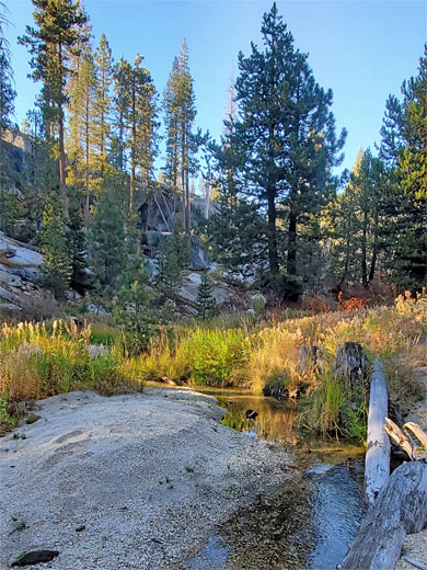
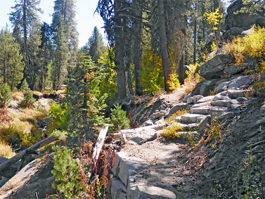
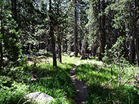
The trailhead for Tamarack Creek, and also for a northwards path to the South Fork of the Tuolumne River, is a small pullout with bear-proof locker, on the south side of Tioga Road, 6 miles east of the Crane Flat junction. The narrow path leads south, to the head of a shallow valley, down through bushes and a few trees to the flat, grassy floor, continuing through another patch of trees then back to the open, and across a tiny stream. Ahead is quite an abrupt edge of a larger patch of woodland; the trail descends a bit more, coming close to a larger stream - Tamarack Creek - and then entering the pines. Half way to the campground it detours west a little way to cross another tributary which, like the main stream, is flowing through a mini canyon with earthen sides up to ten feet high.
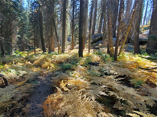
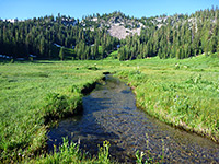
The path runs along the bench on the west side of Tamarack Creek, the water of which in some places flows over bare granite and patches of coarse sand, forming many little pools, some several feet deep. Granite outcrops in the woodland become more frequent, especially across the adjacent slopes to the west. The path enters a wider area of flat wooded land, moving away from the stream and reaching the campground, which has about 40 sites, spread out in clearings in the forest. The access road approaches from the west, while to the east another lightly-used trail leads to various destinations in and above Yosemite Valley.
Devils Dance Floor is reached by walking south from Tamarack Flat Campground, over a tiny stream and up the slope beyond, initially through trees and bushes, quite overgrown, then over granite, an area of pure rock; an intermediate dome. Descending the far side leads into a little ravine, then beyond is a steeper slope, at the north edge of the Dance Floor. Again this is bushy at first, followed by a bigger expanse of granite slickrock, sloping up to the summit, which is fairly flat for around 1000 feet - smooth light gray rock, with potholes and fissures. The best views are from the south and east edges of the summit plateau, across to Yosemite Valley. From the rock the trailhead can clearly be seen, 3 miles north.
There is no trail to the dome though it can be reached relatively easily, by a cross-country walk of just less than one mile, starting from Tamarack Flat Campground, at the end of a narrow, winding, 2.5 mile unpaved track off Tioga Road. The track is however only open to vehicles when the camp is open, typically from June to October, and while at other times the camp could still be accessed on foot by this route, a more interesting and scenic option is to use the Tamarack Creek Trail, 2.6 miles, which also links the camp with Tioga Road, descending into a shallow, partly wooded valley and following a small stream southwards, through a pleasant mix of floral grassland, granite outcrops and patches of trees; worthwhile on its own as well as a route to the Devils Dance Floor.
The total distance to the Dance Floor by this route is 3.7 miles, descending 470 feet down the valley and climbing 500 feet to the dome. The path is little-used, and certainly when the campground is closed there is not likely to be anyone else in this area.
Start of the Trail
The trailhead for Tamarack Creek, and also for a northwards path to the South Fork of the Tuolumne River, is a small pullout with bear-proof locker, on the south side of Tioga Road, 6 miles east of the Crane Flat junction. The narrow path leads south, to the head of a shallow valley, down through bushes and a few trees to the flat, grassy floor, continuing through another patch of trees then back to the open, and across a tiny stream. Ahead is quite an abrupt edge of a larger patch of woodland; the trail descends a bit more, coming close to a larger stream - Tamarack Creek - and then entering the pines. Half way to the campground it detours west a little way to cross another tributary which, like the main stream, is flowing through a mini canyon with earthen sides up to ten feet high.
Path to Tamarack Flat
The path runs along the bench on the west side of Tamarack Creek, the water of which in some places flows over bare granite and patches of coarse sand, forming many little pools, some several feet deep. Granite outcrops in the woodland become more frequent, especially across the adjacent slopes to the west. The path enters a wider area of flat wooded land, moving away from the stream and reaching the campground, which has about 40 sites, spread out in clearings in the forest. The access road approaches from the west, while to the east another lightly-used trail leads to various destinations in and above Yosemite Valley.
Devils Dance Floor
Devils Dance Floor is reached by walking south from Tamarack Flat Campground, over a tiny stream and up the slope beyond, initially through trees and bushes, quite overgrown, then over granite, an area of pure rock; an intermediate dome. Descending the far side leads into a little ravine, then beyond is a steeper slope, at the north edge of the Dance Floor. Again this is bushy at first, followed by a bigger expanse of granite slickrock, sloping up to the summit, which is fairly flat for around 1000 feet - smooth light gray rock, with potholes and fissures. The best views are from the south and east edges of the summit plateau, across to Yosemite Valley. From the rock the trailhead can clearly be seen, 3 miles north.
Topographic Map of the Tamarack Creek Trail
Tamarack Creek Trail and Devils Dance Floor - Similar Hikes
All Contents © Copyright The American Southwest | Comments and Questions | Contribute | Affiliate Marketing Disclosure | Site Map