

Highlights:
Sandstone bluffs and cliffs, narrow sandy beaches, wave-carved formations, many tidepools and much sea life, along a 2 mile section of the Pacific coast of Point Loma
Nearby town:
Management:
The communities of Sunset Beach and Ocean Beach
Location:
32.718, -117.252 - Point Loma East parking lot, Sunset Cliffs Natural Park
Seasons:
All year
Rating (1-5):
★★★★★
Weather:


Sunset Cliffs is part of the California South Coast itinerary
Featured Hotel
Best Western Yacht Harbor Hotel
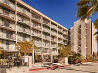 Six floor property alongside Harbor Boulevard, about a 3 minute walk from edge of San Diego Bay, close to shops and restaurants
Check Rates
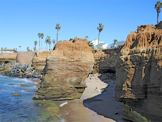
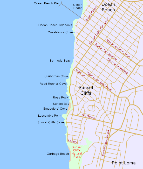
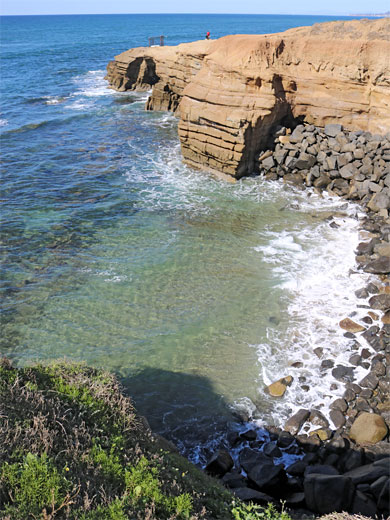
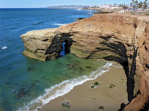
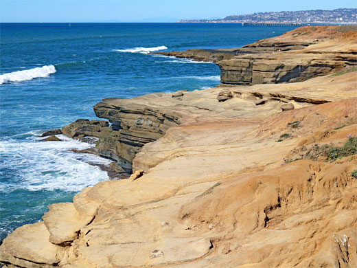
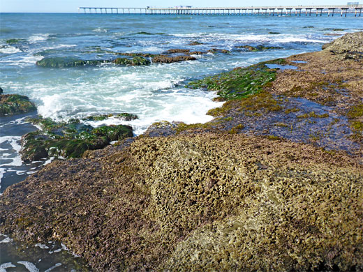
Sunset Cliffs and Ocean Beach are residential districts on the west side of Point Loma, San Diego, and also the names of the adjacent sections of the Pacific coast, together extending just over 2 miles. All this area is developed, the coast lined by many houses, some especially large and elegant, leaving just a narrow strip of grass and bluffs between the city streets and the ocean, which is backed by low cliffs of orange/brown sedimentary rock, a mix of sandstone, conglomerate and shale. Below the cliffs are some stretches of sand, but mostly shingle, boulders or marine terraces, these containing numerous tidepools, plus a few larger erosional features including arches, sea caves and sea stacks.
Several hours could be spent exploring this part of the coast, which stretches from the edge of Naval Base Point Loma in the south to Ocean Beach Pier in the north; walking along paths or roads, descending to sea level as required, or where possible. The Sunset Cliff section is contained within a Natural Park, which comprises a wider, more overgrown section at the south end, and a narrow, linear section stretching northwards.
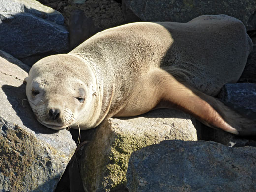
Also of interest, apart from the rock formations and the beaches, are abundant wildflowers, albeit many non-native species, and plenty of sea life, including seals and sea lions.
There are various free parking places along this part of the coast, on streets and in a few dedicated lots, the largest to the south end, serving the inland portion of Sunset Cliffs Natural Park - one off Lomaland Drive the other at the south end of Ladera Street.
Several hours could be spent exploring this part of the coast, which stretches from the edge of Naval Base Point Loma in the south to Ocean Beach Pier in the north; walking along paths or roads, descending to sea level as required, or where possible. The Sunset Cliff section is contained within a Natural Park, which comprises a wider, more overgrown section at the south end, and a narrow, linear section stretching northwards.
Also of interest, apart from the rock formations and the beaches, are abundant wildflowers, albeit many non-native species, and plenty of sea life, including seals and sea lions.
There are various free parking places along this part of the coast, on streets and in a few dedicated lots, the largest to the south end, serving the inland portion of Sunset Cliffs Natural Park - one off Lomaland Drive the other at the south end of Ladera Street.
Sunset Cliffs Table of Contents
- Map of the La Sunset Cliffs and Ocean Beach
- Photographs
- Sunset Cliffs Natural Park
- Garbage Beach to Claibornes Cove
- Ocean Beach
- Nearby places
- Similar places
Map of Sunset Cliffs and Ocean Beach
Photographs
30 views of Sunset Cliffs and Ocean Beach.
Sunset Cliffs Natural Park
The main portion of Sunset Cliffs Natural Park, which extends inland about a third of mile, consists of grassy, bushy bluffs and a sandy beach, below cliffs of up to 80 feet high, accessed via a steep route at its north end; supposedly considered one of the most difficult beaches to access in all the San Diego area. The sands are known as Garbage Beach since an adjacent canyon was once used as an unofficial trash repository. The sandy portion is at low tide bordered to the south, west and north by rock terraces and pools; those to the north are also accessible via a flight of steps down from the end of Ladera Street.
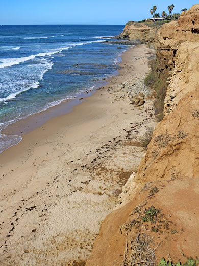
Garbage Beach to Claibornes Cove
North of Garbage Beach, the inter-tidal zone is much narrower, and the base of the cliffs rarely accessible. Walking continues on a road, Sunset Cliffs Boulevard, above the cliff-bound section, passing several small points and two little bays, and also Sunset Cliffs Cave, a circular, sheer-walled depression mostly flooded by the sea through a tunnel at the base, securely fenced off above and accessible from below by an unofficial route only for short time around the very lowest tides. Just beyond is a larger area of bluffs, Luscomb's Point, and the second main sandy beach whereabouts, Sunset Beach, or Smuggler's Cove. This too is surrounded by rocky terraces at low tide. North of this beach are a large sea stack (Ross Rock), more low cliffs and small promontories, some with inaccessible coves below, and at least one arch, on the south side of Claibornes Cove, which contains a mixture of sand and rock plus one large sea stack. Just to the north is one more promontory, opposite Adair Street, which marks the end of the Sunset Cliffs.
Ocean Beach
For the half mile north of Adair Street, there is no walking route directly along the coast, as houses extend right to the edge of the shoreline, accessible via a series of dead-end roads, though still with some access down to sea level including at Bermuda Beach, at the end of Bermuda Avenue. The next more open section of the coast begins at Casablanca Cove, at the end of Santa Cruz Avenue - a band of terraces, ledges and pools, the Ocean Beach Tidepool Area, which extends to the base of Ocean Beach Pier, a third-of-a-mile-long structure currently awaiting repairs after storm damage. This marks the end of the rocky section of the Point Loma coast, as beyond are the sands of the main part of Ocean Beach, and then the breakwaters at the mouth of Mission Bay.
Sunset Cliffs - Nearby Places
- Cabrillo National Monument (3 miles) - rocky peninsula bordering San Diego Bay
- La Jolla Tide Pools (14 miles) - wave-carved pools, sea caves, terraces and other rock formations
Sunset Cliffs- Similar Places
- Salt Point State Park - scenic Pacific Ocean cliffs in Sonoma County
- Torrey Pines State Reserve - dunes, beaches, wildflower-covered hillsides and eroded sandstone cliffs
All Contents © Copyright The American Southwest | Comments and Questions | Contribute | Affiliate Marketing Disclosure | Site Map