Sabrina Lake Trail
Relatively easy path, climbing not too steeply, that follows the upper reaches of the Middle Fork of Bishop Creek, initially to Blue Lake, then past several more lakes to Hungry Packer Lake, below Mt Haeckel. A short diversion leads to nearby Moonlight Lake
Length: 6.3 miles, to Hungry Packer Lake
Elevation change: 2,000 feet
Difficulty: Moderate; not too steep, and partly shaded
Type: One-way
Usage: Medium to Blue Lake; low beyond
Season: Early summer to early fall
Trailhead: Lake Sabrina Road
Rating (1-5): ★★★★★
Elevation change: 2,000 feet
Difficulty: Moderate; not too steep, and partly shaded
Type: One-way
Usage: Medium to Blue Lake; low beyond
Season: Early summer to early fall
Trailhead: Lake Sabrina Road
Rating (1-5): ★★★★★

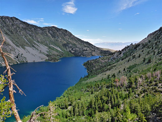
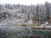
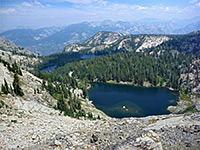
Lake Sabrina, elevation 9,128 feet, is one of the most popular access points into the Eastern Sierra, since it is reached by a good, 18 mile paved road, Hwy 168, which forks off US 395 in Bishop, so hikers are just half an hour's drive from the many shops and restaurants in town. The lake is artificial, created in 1908 by construction of a dam across the Middle Fork of Bishop Creek, and is named after Sabrina Hobbs, wife of the manager of the power company who owned the dam.
The main hiking path hereabouts, the Sabrina Lake Trail , follows the southeastern shore of the mile-long reservoir then climbs steadily but not too steeply past a succession of natural lakes, all different in appearance - Blue, Dingleberry, Topsy Turvy, Sailor and finally Hungry Packer, elevation 11,071 feet, where the path ends, close to the dramatic granite cliffs below Mt Haeckel and Mt Wallace, along the Sierra Crest. Another lake, Moonlight, can be seen by a short off-trail continuation, and the round trip to all - 13 miles, gaining 2,000 feet - is consistently spectacular all the way, with ever-changing views and varied habitats, of wet and dry meadows, woodland, granite slickrock and tundra, resulting in a great variety of wildflowers.
For backpackers the main camping location is beside Sailor Lake, near the end of the trail, from where several other lakes may be visited, some cross-country. Many hikers though go only as far as Blue Lake, (2.8 miles, 1,300 feet); the onwards path is occasionally difficult to follow but not at all strenuous. All the land is part of the Inyo National Forest, and most of the hike is within the John Muir Wilderness, the boundary being 0.8 miles from the trailhead.
45 views along the Sabrina Lake Trail
Sabrina Lake Trail topo map. Overview map of the Eastern Sierra
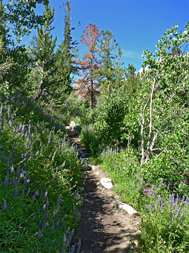
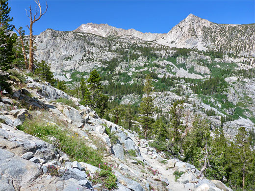
The Lake Sabrina trailhead is near the end of the road, shortly before a bridge over the fast flowing waters of Bishop Creek. There are plenty of verges for overflow parking, a short distance back. The path starts off through shady woodland, climbing gently, soon coming into view of the lake, while heading southwest through gradually thinning trees, mingling with numerous different types of flowering plants. The path levels out, staying around 100 feet above the lake, crossing a few tiny streams near the start after which the land becomes drier, and the ground sprinkled with many granite boulders. A sign marks the edge of the John Muir Wilderness, soon followed by another, larger stream after which the gradient starts to increase, as the trail passes a junction with a less-used route to George Lake and the Tyee Lakes.
The next creek (from George Lake) forms some small waterfalls below the path, and here the views are better, over the dramatic granite slopes above the far end of the lake, where Bishop Creek flows steeply down, over many more cascades. The path now climbs more sharply, via a series of tight switchbacks through more wooded terrain, before emerging from the trees to a flat granite slab, another good viewpoint of the lake, now 1,000 feet below. The trail re-enters the forest, leads up a cool, shady gully followed by a rocky chute with many columbines, then a final ascent, over a saddle and past a dark-water pond to the north end of Blue Lake, just upstream of a cascade along its exit stream.
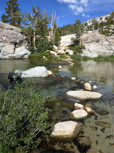
The stream draining Blue Lake is crossed by a line of logs and boulders, after which the trail, not always easy to identify, traverses some white granite benches close to the shoreline. On the far side of the lake the land rises steeply to the jagged granite crags of Thompson Ridge. The onwards path continues nearly a mile to Donkey Lake, but most people turn right at a junction, signed Dingleberry Lake. This trail is fairly flat, crossing sparse woodland, past a pond, down a little into a rocky gully and through more woods and boulders to another pond, actually one of the (small) Emerald Lakes, most of which are off-trail to the south.. The path rises over a low divide and drops down the next lake, Dingleberry, descending right to the water's edge, down a ravine lined with many arnica flowers. It follows the eastern shoreline, over some boggy patches, and on to a sign at a fork in the trail, marked right for hikers and left for stock; the former crosses the lake's inlet stream (Bishop Creek), here about 80 feet wide, via stepping stones, which may be submerged during the snowmelt season. After here the ground rises to a pretty, moist meadow either side of Bishop Creek, crossed by tiny meandering tributary streams, with many more wildflowers.
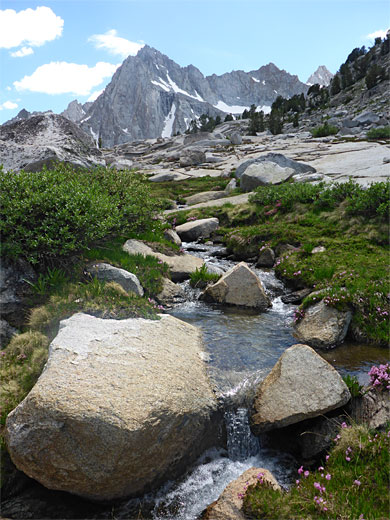
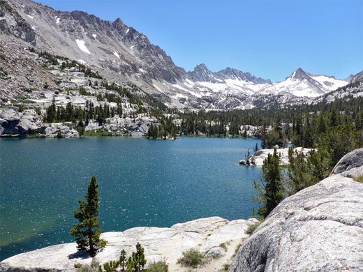
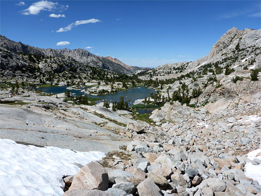
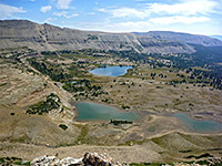
From the Bishop Creek meadows, the trail has a short climb to a ridge, coming close to the stream once more, then passes the junction with the 0.5 mile spur to Midnight Lake followed by two stream crossings and a third, much smaller, in the middle of a tiny meadow, before reaching the top of a ridge, with views down to Topsy Turvy Lake 100 feet below, easily reached by walking down slickrock slopes. This lake has many boulders in the water, and is bordered on the far side by a very steep slope of light-colored granite. The trail proceeds south along a bench, rising gently and reaching the extensive meadows that lead to Sailor Lake, a popular campsite, on a rocky spur just east of the lake's exit stream; a spectacular location with bare granite all around and peaks rising high above.
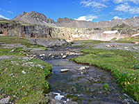
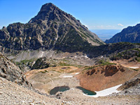
The last section of the trail, 0.3 miles and nearly level, is to Hungry Packer Lake, even more dramatic, set beneath cliffs, snow and scree below a curving ridge leading from Mt Wallace and Mt Haeckel, a vista best viewed from a little granite dome between the main part of the lake and a narrow inlet. One other lake in the vicinity is Moonlight, not on an official trail but easily reached by a cross-country walk alongside the stream linking it to Sailor Lake, or by contouring across the slopes from Hungry Packer Lake. The approach is over a great pile of huge, jagged boulders, which extends into the water, creating little lagoons. More peaks are now in view including Mt Thompson, Mt Powell and the Clyde Spires.
The main hiking path hereabouts, the Sabrina Lake Trail , follows the southeastern shore of the mile-long reservoir then climbs steadily but not too steeply past a succession of natural lakes, all different in appearance - Blue, Dingleberry, Topsy Turvy, Sailor and finally Hungry Packer, elevation 11,071 feet, where the path ends, close to the dramatic granite cliffs below Mt Haeckel and Mt Wallace, along the Sierra Crest. Another lake, Moonlight, can be seen by a short off-trail continuation, and the round trip to all - 13 miles, gaining 2,000 feet - is consistently spectacular all the way, with ever-changing views and varied habitats, of wet and dry meadows, woodland, granite slickrock and tundra, resulting in a great variety of wildflowers.
For backpackers the main camping location is beside Sailor Lake, near the end of the trail, from where several other lakes may be visited, some cross-country. Many hikers though go only as far as Blue Lake, (2.8 miles, 1,300 feet); the onwards path is occasionally difficult to follow but not at all strenuous. All the land is part of the Inyo National Forest, and most of the hike is within the John Muir Wilderness, the boundary being 0.8 miles from the trailhead.
Photographs
45 views along the Sabrina Lake Trail
Maps
Sabrina Lake Trail topo map. Overview map of the Eastern Sierra
Sabrina Lake Trailhead
The Lake Sabrina trailhead is near the end of the road, shortly before a bridge over the fast flowing waters of Bishop Creek. There are plenty of verges for overflow parking, a short distance back. The path starts off through shady woodland, climbing gently, soon coming into view of the lake, while heading southwest through gradually thinning trees, mingling with numerous different types of flowering plants. The path levels out, staying around 100 feet above the lake, crossing a few tiny streams near the start after which the land becomes drier, and the ground sprinkled with many granite boulders. A sign marks the edge of the John Muir Wilderness, soon followed by another, larger stream after which the gradient starts to increase, as the trail passes a junction with a less-used route to George Lake and the Tyee Lakes.
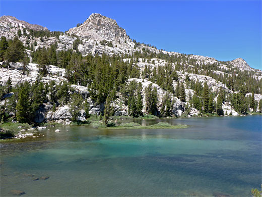
Blue Lake
The next creek (from George Lake) forms some small waterfalls below the path, and here the views are better, over the dramatic granite slopes above the far end of the lake, where Bishop Creek flows steeply down, over many more cascades. The path now climbs more sharply, via a series of tight switchbacks through more wooded terrain, before emerging from the trees to a flat granite slab, another good viewpoint of the lake, now 1,000 feet below. The trail re-enters the forest, leads up a cool, shady gully followed by a rocky chute with many columbines, then a final ascent, over a saddle and past a dark-water pond to the north end of Blue Lake, just upstream of a cascade along its exit stream.
Emerald Lakes and Dingleberry Lake
The stream draining Blue Lake is crossed by a line of logs and boulders, after which the trail, not always easy to identify, traverses some white granite benches close to the shoreline. On the far side of the lake the land rises steeply to the jagged granite crags of Thompson Ridge. The onwards path continues nearly a mile to Donkey Lake, but most people turn right at a junction, signed Dingleberry Lake. This trail is fairly flat, crossing sparse woodland, past a pond, down a little into a rocky gully and through more woods and boulders to another pond, actually one of the (small) Emerald Lakes, most of which are off-trail to the south.. The path rises over a low divide and drops down the next lake, Dingleberry, descending right to the water's edge, down a ravine lined with many arnica flowers. It follows the eastern shoreline, over some boggy patches, and on to a sign at a fork in the trail, marked right for hikers and left for stock; the former crosses the lake's inlet stream (Bishop Creek), here about 80 feet wide, via stepping stones, which may be submerged during the snowmelt season. After here the ground rises to a pretty, moist meadow either side of Bishop Creek, crossed by tiny meandering tributary streams, with many more wildflowers.
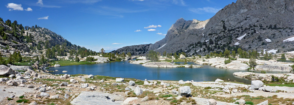
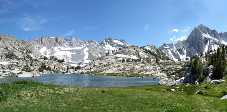
Topsy Turvy Lake and Sailor Lake
From the Bishop Creek meadows, the trail has a short climb to a ridge, coming close to the stream once more, then passes the junction with the 0.5 mile spur to Midnight Lake followed by two stream crossings and a third, much smaller, in the middle of a tiny meadow, before reaching the top of a ridge, with views down to Topsy Turvy Lake 100 feet below, easily reached by walking down slickrock slopes. This lake has many boulders in the water, and is bordered on the far side by a very steep slope of light-colored granite. The trail proceeds south along a bench, rising gently and reaching the extensive meadows that lead to Sailor Lake, a popular campsite, on a rocky spur just east of the lake's exit stream; a spectacular location with bare granite all around and peaks rising high above.
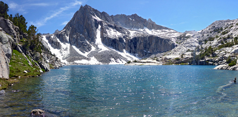
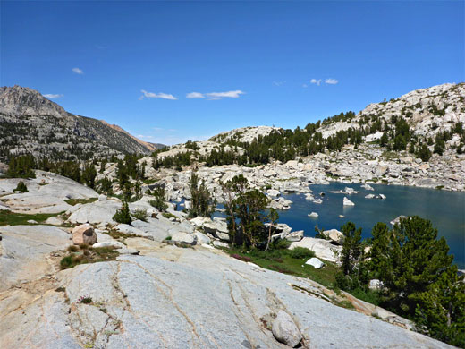
Hungry Packer Lake and Moonlight Lake
The last section of the trail, 0.3 miles and nearly level, is to Hungry Packer Lake, even more dramatic, set beneath cliffs, snow and scree below a curving ridge leading from Mt Wallace and Mt Haeckel, a vista best viewed from a little granite dome between the main part of the lake and a narrow inlet. One other lake in the vicinity is Moonlight, not on an official trail but easily reached by a cross-country walk alongside the stream linking it to Sailor Lake, or by contouring across the slopes from Hungry Packer Lake. The approach is over a great pile of huge, jagged boulders, which extends into the water, creating little lagoons. More peaks are now in view including Mt Thompson, Mt Powell and the Clyde Spires.
Sabrina Lake Wildflowers
More flowers along the trail
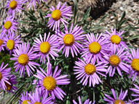 Sierra fleabane |
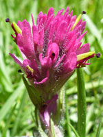 Lemmon's indian paintbrush |
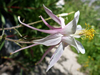 Sierra columbine |
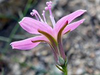 Narrowleaf wire-lettuce |
More flowers along the trail
Sabrina Lake Trail - Similar Hikes
All Contents © Copyright The American Southwest | Comments and Questions | Contribute | Affiliate Marketing Disclosure | Site Map