Room Canyon, Death Valley National Park
California > Death Valley National Park > The South > Room Canyon
Room Canyon
Minor drainage in the Black Mountains, towards the south end of Death Valley, with a short narrow section that opens to a dramatic, cliff-lined chamber; the room. Nearby are some red conglomerate pinnacles
Length: 1.2 miles
Elevation change: 380 feet
Difficulty: Easy
Type: One way, off-trail
Usage: Low
Season: Fall, winter, spring
Trailhead: Verge along Badwater Road, 4.8 miles north of Ashford Mill Ruins
Rating (1-5): ★★★★★
Elevation change: 380 feet
Difficulty: Easy
Type: One way, off-trail
Usage: Low
Season: Fall, winter, spring
Trailhead: Verge along Badwater Road, 4.8 miles north of Ashford Mill Ruins
Rating (1-5): ★★★★★

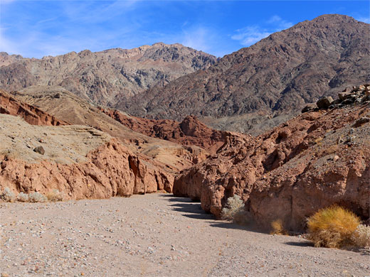
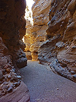
Room Canyon is the unofficial name of a minor drainage in the Black Mountains, towards the south side of Death Valley National Park, so-called for an enclosed, cliff-bound chamber, reached after a walk of just over a mile, starting from Badwater Road; over an alluvial plain and into the drainage, along the streambed a short distance, then through a short narrow section to the room.
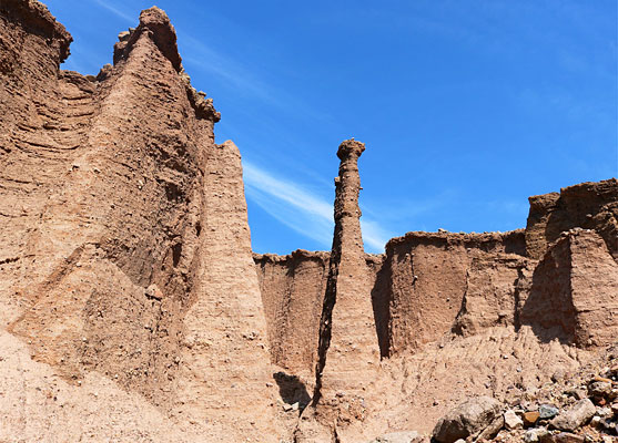
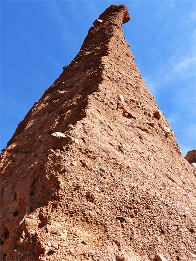
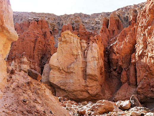
Along the way are a couple of short, slot canyon tributaries and a group of reddish pinnacles, one particularly tall and thin. Overall, the canyon is not a major attraction, and all can be explored in just an hour or two, though it is still worthy of exploration, given the easy access.
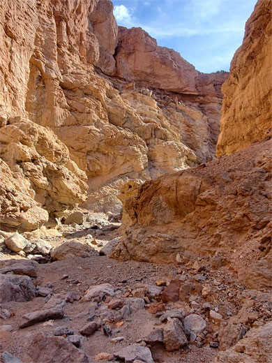
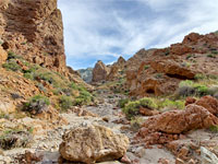
Most of the hike is across alluvial gravel. The rocks surrounding the lower portion of the canyon, including the pinnacle area, are red, coarse-grained conglomerate, while the cliffs of the room are formed of greenish-pink diorite, a formation that extends a long way further up into the mountains.
Map of Death Valley National Park and surroundings.
25 views of Room Canyon.
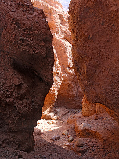
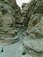
The canyon is of course not signposted, and there is no parking place apart from the gravelly verge of Badwater Road, 4.8 miles north of Ashford Mill Ruins. The mouth of the drainage is fairly obvious, as a gap in the low hills half a mile east, reached by a quick walk over the flat, stony ground. At the edge of the hills, the streamway bends to the north and soon becomes enclosed by low, conglomerate walls. After a short distance are two small tributaries on the left, one, with a blocking boulder at its mouth, leads to the main group of eroded pinnacles, or hoodoos, while the second, a hundred feet beyond, forms a shallow slot canyon, with a couple of hundred feet of narrow passageways before becoming shallow.
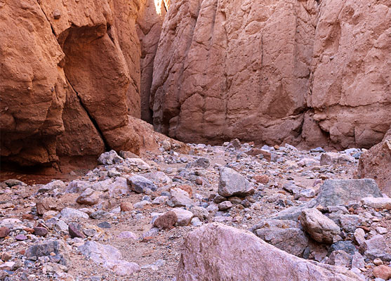
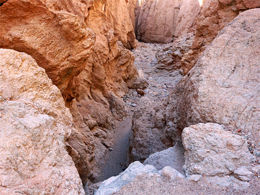
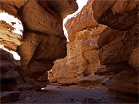
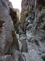
The main drainage then enters a deeper narrows section - the cliffs are taller, much closer together, and at one point the passageway is partially blocked by a huge fallen boulder. The ravine briefly opens out at the junction with the south fork of the drainage, which is open, and looks uninteresting, while just beyond the main fork narrows again, and a shorter passageway leads to the room - a wide chamber flanked by vertical cliffs. Towards the far end is a dryfall, then a somewhat shallower extension, the canyon floor now littered with colorful boulders. Beyond this the drainage quickly becomes shallow and later splits into several tributaries which gain height much more steeply.
Along the way are a couple of short, slot canyon tributaries and a group of reddish pinnacles, one particularly tall and thin. Overall, the canyon is not a major attraction, and all can be explored in just an hour or two, though it is still worthy of exploration, given the easy access.
Most of the hike is across alluvial gravel. The rocks surrounding the lower portion of the canyon, including the pinnacle area, are red, coarse-grained conglomerate, while the cliffs of the room are formed of greenish-pink diorite, a formation that extends a long way further up into the mountains.
Location
Map of Death Valley National Park and surroundings.
Photographs
25 views of Room Canyon.
Room Canyon Video
The Canyon
The canyon is of course not signposted, and there is no parking place apart from the gravelly verge of Badwater Road, 4.8 miles north of Ashford Mill Ruins. The mouth of the drainage is fairly obvious, as a gap in the low hills half a mile east, reached by a quick walk over the flat, stony ground. At the edge of the hills, the streamway bends to the north and soon becomes enclosed by low, conglomerate walls. After a short distance are two small tributaries on the left, one, with a blocking boulder at its mouth, leads to the main group of eroded pinnacles, or hoodoos, while the second, a hundred feet beyond, forms a shallow slot canyon, with a couple of hundred feet of narrow passageways before becoming shallow.
The Room
The main drainage then enters a deeper narrows section - the cliffs are taller, much closer together, and at one point the passageway is partially blocked by a huge fallen boulder. The ravine briefly opens out at the junction with the south fork of the drainage, which is open, and looks uninteresting, while just beyond the main fork narrows again, and a shorter passageway leads to the room - a wide chamber flanked by vertical cliffs. Towards the far end is a dryfall, then a somewhat shallower extension, the canyon floor now littered with colorful boulders. Beyond this the drainage quickly becomes shallow and later splits into several tributaries which gain height much more steeply.
Room Canyon - Similar Hikes
All Contents © Copyright The American Southwest | Comments and Questions | Contribute | Affiliate Marketing Disclosure | Site Map