Highlights:
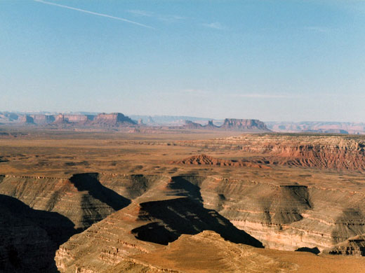
Viewpoint and primitive camp location, right on the rim of the 1,200 foot cliffs on the south side of Cedar Mesa, overlooking the San Juan River, plus distant views of Monument Valley
Location:
Seasons:
All year
Rating (1-5):
★★★★★

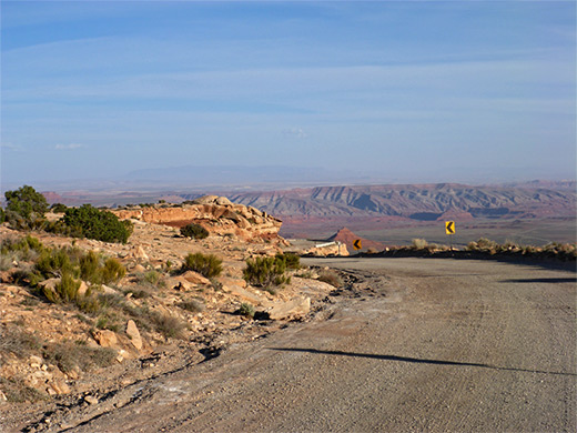
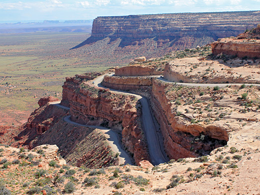
An alternative route (UT 261) away from Mexican Hat branches northwards off US 163, starting with a near-straight ten mile stretch across the valley floor (alongside the edge of Valley of the Gods), then temporarily deteriorating to a gravel road with steep inclines and 180 degree turns as it ascends 1,200 feet to the top of a high plateau (Cedar Mesa).
This part is known as the Moki Dugway after an old Mormon term for the Anasazi peoples who once inhabited this region. Warning signs discourage vehicles of over 20 feet, but if driven carefully, RVs of 25 feet or over can make the journey easily enough. From the top of the cliffs there stretches an immense vista southwards over the empty plains of the Navajo Reservation, with Monument Valley clearly visible over 20 miles away, and many more buttes, cliffs and volcanic spires in the distance to the southwest.
This part is known as the Moki Dugway after an old Mormon term for the Anasazi peoples who once inhabited this region. Warning signs discourage vehicles of over 20 feet, but if driven carefully, RVs of 25 feet or over can make the journey easily enough. From the top of the cliffs there stretches an immense vista southwards over the empty plains of the Navajo Reservation, with Monument Valley clearly visible over 20 miles away, and many more buttes, cliffs and volcanic spires in the distance to the southwest.
Moki Dugway Video
Speeded up four times, this is the view driving up the Moki Dugway in a 19 foot RV.
The Viewpoint
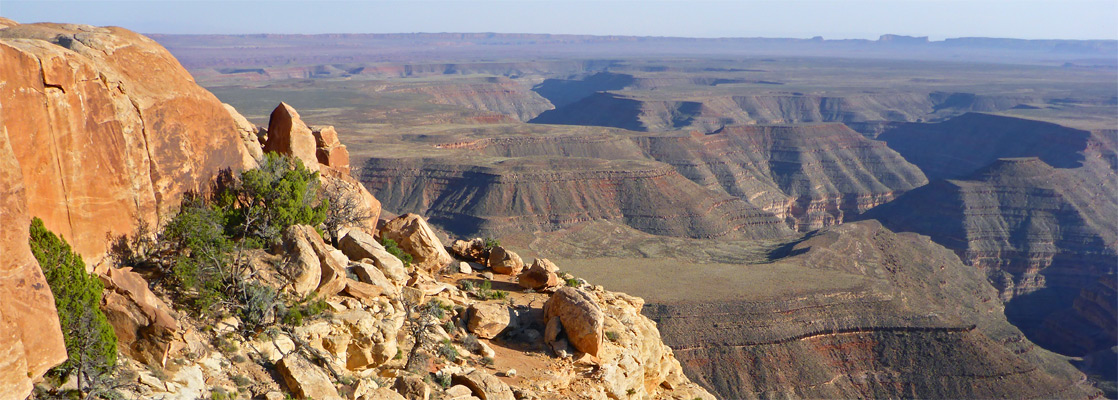
At the top of the dugway a 5 mile gravel track leads southwest through BLM land to Muley Point overlook, which has more sweeping views south over the twisting, entrenched canyons of the San Juan River and to the desert beyond. This is a peaceful location, not often visited, and has many places where it is possible to drive off road and camp right at the edge of the sheer cliffs - one of the best (free) camping places in Utah. The very end of the road enters the Glen Canyon NRA and there are a couple of other tracks heading further west, but after a few miles a deep tributary of the San Juan River (Johns Canyon) puts an end to further travel in this direction. From the junction with the gravel track it is about 60 miles north along UT 261 and UT 95 to the upper end of Lake Powell at Hite along White Canyon, a drive which passes close to many sites of interest including the Cedar Mesa plateau - crossed by many canyons containing numerous Anasazi ruins, Natural Bridges National Monument, White Canyon and its tributary slot canyons and Dark Canyon.
All Contents © Copyright The American Southwest | Comments and Questions | Contribute | Affiliate Marketing Disclosure | Site Map