Pine Creek
Most popular of Zion's technical slot canyons, deepening rapidly via chokestones and dryfalls that require rappels of up to 100 feet. Hikers may see the very beginning of the slot, and a short narrows section further upstream
Length: 0.1 miles for the start of the slot, 0.3 miles for the upstream narrows
Difficulty: Easy, for the hiking
Management: NPS - within Zion National Park
Rocks: Navajo sandstone
Season: Spring, summer, fall
Trailhead: Parking area just east of the Zion-Mt Carmel tunnel. Other pullouts are located a little way east
Rating (1-5): ★★★★★
Difficulty: Easy, for the hiking
Management: NPS - within Zion National Park
Rocks: Navajo sandstone
Season: Spring, summer, fall
Trailhead: Parking area just east of the Zion-Mt Carmel tunnel. Other pullouts are located a little way east
Rating (1-5): ★★★★★

Pine Creek flows through a long straight canyon in the southeast section of Zion National Park towards UT 9, the Zion-Mt Carmel highway, where it is joined by Clear Creek, an even longer tributary that runs alongside the road eastwards through a fantastic red and white landscape of sheer cliffs and huge domed rocks.
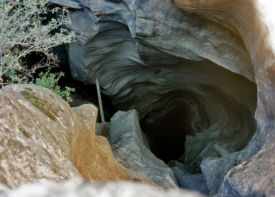
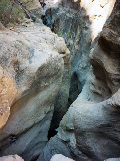
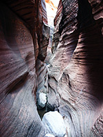
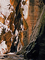
As Pine Creek flows under the highway, just before the start of the long tunnel that separates this area from the main valley, it enters a half mile section of deep narrows, which has become most popular technical slot canyon in the park. This cannot be explored without rappelling equipment since the creek quickly drops far below ground in a series of sheer falls, but for regular hikers it is worthwhile just to walk along the canyon rim and peer into the swirling depths.
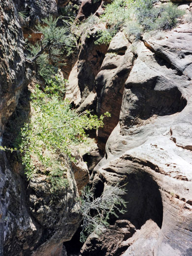
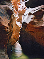
There is also a shallow though still photogenic section of narrows just upstream of the bridge, often partially flooded, with muddy pools up to 3 feet deep, but otherwise without any obstacles.
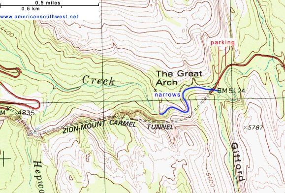
The upper end of the slot canyon may be entered by walking down the sandy banks at the far side of a small carpark (no RVs) just before the east entrance of the Zion-Mt Carmel tunnel, and opposite the start of the popular Canyon Overlook Trail. If the carpark is full, as is usually the case, there are other places to leave vehicles a little way further along the main road. For those descending the whole canyon, a car shuttle may be needed - either that or hitch-hiking through the tunnel back to the trailhead.
A $35 Zion National Park entry fee is required to reach this area, plus a permit for all those who rappel into the canyon (2025 fees: $6 per permit application plus $10 per person) - according to new regulations introduced in 2000 and subsequently modified several times, this is necessary for all slot canyon exploration within the park that involves overnight back-country travel and/or rope-assisted climbing. Permits may be obtained up to three months in advance, online, or via the 'daily lottery', also online, two days before the intended visit.
22 views of Pine Creek.
The upper narrows, just upstream of the road bridge.
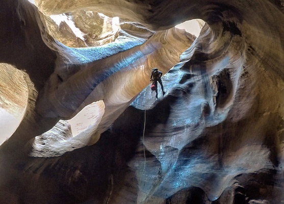
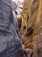
Pine Creek is quite interesting upstream - after a short walk from the carpark the drainage forms a deep section in which pools persist most of the year, and the long Clear Creek tributary also has many narrow places. In the other direction, the true slot canyon begins directly under the road bridge but very soon a dryfall puts an end to easy progress. A belay point on the right indicates the only way to continue - with several long ropes (up to 150 feet) and rappelling experience all of the short but deep slot can be explored, until it opens out into a boulder filled ravine which widens further to the wide valley beneath the rock formation known as Great Arch, as the stream meanders towards its confluence with the East Fork of the Virgin River. Up to six rappels are required, plus downclimbing over several chokestones and at least one swim through a 50 foot long pool of water (except maybe during long, dry periods in midsummer) that remains icy cold all year, but Pine Creek is a good place for beginner canyoneers as it is easily accessed and closely monitored by the NPS. An easier option is to walk above the narrows along the south side, where a faint path follows close to the rim through land which is quite rough and overgrown. There are several places that offer rather alarming views into the depths, before the way ahead becomes too steep for the path to continue. A fine overview of the slot can be obtained by walking along the Canyon Overlook Trail, high above the narrows.
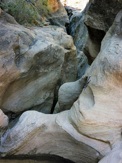
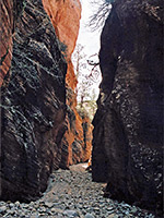
A short distance upstream of the deep, technical slot, Pine Creek forms a 1,000-foot long narrows section, as the canyon curves through a tight U-bend; this may also be accessed from the small parking place at the tunnel entrance, or from pullouts further east, including the one used for the Canyon Overlook Trail. From here, a walk down a short slope reaches the streambed, heading south towards high cliffs, and soon becoming enclosed, with a mix of sand, pebbles and boulders on the floor, and a few logs jammed above. The drainage deepens and narrows further, the floor now sand or mud, and often partially flooded. After the deepest and longest pool, the ravine quickly opens out, as it approaches the highway bridge and the tunnel entrance.
As Pine Creek flows under the highway, just before the start of the long tunnel that separates this area from the main valley, it enters a half mile section of deep narrows, which has become most popular technical slot canyon in the park. This cannot be explored without rappelling equipment since the creek quickly drops far below ground in a series of sheer falls, but for regular hikers it is worthwhile just to walk along the canyon rim and peer into the swirling depths.
There is also a shallow though still photogenic section of narrows just upstream of the bridge, often partially flooded, with muddy pools up to 3 feet deep, but otherwise without any obstacles.
Topographic Map of Pine Creek
Location
The upper end of the slot canyon may be entered by walking down the sandy banks at the far side of a small carpark (no RVs) just before the east entrance of the Zion-Mt Carmel tunnel, and opposite the start of the popular Canyon Overlook Trail. If the carpark is full, as is usually the case, there are other places to leave vehicles a little way further along the main road. For those descending the whole canyon, a car shuttle may be needed - either that or hitch-hiking through the tunnel back to the trailhead.

Permit
A $35 Zion National Park entry fee is required to reach this area, plus a permit for all those who rappel into the canyon (2025 fees: $6 per permit application plus $10 per person) - according to new regulations introduced in 2000 and subsequently modified several times, this is necessary for all slot canyon exploration within the park that involves overnight back-country travel and/or rope-assisted climbing. Permits may be obtained up to three months in advance, online, or via the 'daily lottery', also online, two days before the intended visit.
Photographs
22 views of Pine Creek.
Pine Creek Video
The upper narrows, just upstream of the road bridge.
Route Description for Pine Creek
Pine Creek is quite interesting upstream - after a short walk from the carpark the drainage forms a deep section in which pools persist most of the year, and the long Clear Creek tributary also has many narrow places. In the other direction, the true slot canyon begins directly under the road bridge but very soon a dryfall puts an end to easy progress. A belay point on the right indicates the only way to continue - with several long ropes (up to 150 feet) and rappelling experience all of the short but deep slot can be explored, until it opens out into a boulder filled ravine which widens further to the wide valley beneath the rock formation known as Great Arch, as the stream meanders towards its confluence with the East Fork of the Virgin River. Up to six rappels are required, plus downclimbing over several chokestones and at least one swim through a 50 foot long pool of water (except maybe during long, dry periods in midsummer) that remains icy cold all year, but Pine Creek is a good place for beginner canyoneers as it is easily accessed and closely monitored by the NPS. An easier option is to walk above the narrows along the south side, where a faint path follows close to the rim through land which is quite rough and overgrown. There are several places that offer rather alarming views into the depths, before the way ahead becomes too steep for the path to continue. A fine overview of the slot can be obtained by walking along the Canyon Overlook Trail, high above the narrows.

The Accessible Narrows
A short distance upstream of the deep, technical slot, Pine Creek forms a 1,000-foot long narrows section, as the canyon curves through a tight U-bend; this may also be accessed from the small parking place at the tunnel entrance, or from pullouts further east, including the one used for the Canyon Overlook Trail. From here, a walk down a short slope reaches the streambed, heading south towards high cliffs, and soon becoming enclosed, with a mix of sand, pebbles and boulders on the floor, and a few logs jammed above. The drainage deepens and narrows further, the floor now sand or mud, and often partially flooded. After the deepest and longest pool, the ravine quickly opens out, as it approaches the highway bridge and the tunnel entrance.

Pine Creek - Similar Hikes
All Contents © Copyright The American Southwest | Comments and Questions | Contribute | Affiliate Marketing Disclosure | Site Map