Trails in the East of Rocky Mountain National Park
Colorado > Rocky Mountain National Park > Trails in the East
Unlike most national parks where each trail leads to one specific destination, paths in Rocky Mountain NP typically reach several scenic spots - lakes, waterfalls, summits and viewpoints - and the paths intersect so many of the places can be accessed by more than one trail. Hence the trails are best summarized by the locations reachable from each trailhead, rather than trail name.
Trails in the more popular east section of the national park start along US 34, US 36, highway 7, or several side roads in the Moraine Park/Beaver Meadows/Bear Lake area. The most visited destinations are (with trailhead): Nymph Lake and Dream Lake (Bear Lake), Cub Lake (Cub Lake), Alberta Falls and Mills Lake (Glacier Gorge), Chasm Lake (Longs Peak), Copeland Falls and Calypso Cascades (Wild Basin).
See also the listing of trails in the west of the national park.
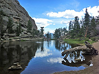
The Rocky Mountain National Park map indicates the location of all trailheads.
 |
|||
| Trailhead with selected destinations |
Length (one way) (miles) |
Elevation Change (feet) |
Trail Description |
| Bowen/Baker | After a short, level section across Kawuneeche Valley and the Colorado River, the path from the Bowen/Baker trailhead splits, with both branches soon exiting the park into the Arapaho National Forest and climbing to two high passes on the continental divide in the Never Summer Mountains - 11,476 foot Bowen Pass and 11,253 foot Baker Pass. | ||
| Bowen Pass | 10.0 | 2,610 | |
| Baker Pass | 5.8 | 2,390 | |
| Allenspark | Allenspark is an alternative trailhead used to reach Finch Lake and Pear Lake, and may be accessed by a 1.5 mile side road off highway 7; the route is a little shorter and involves less elevation gain than the path starting at the Finch Lake trailhead. The junction with the Finch Lake Trail arrives after a 1.7 mile walk up a densely forested hillside. | ||
| Finch Lake Tr | 1.7 | 840 | |
| Finch Lake | 3.9 | 1,030 | |
| Pear Lake | 5.9 | 1,700 | |
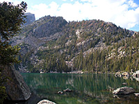
| Bear Lake | The close proximity to much beautiful scenery and several peaks along the continental divide makes Bear Lake the most popular trailhead in Rocky Mountain National Park. An easy half mile path circles the lake itself, while three other trails lead into the backcountry. One climbs the wooded hillside at the north edge of the lake for half a mile to a junction; the right branch descends gently through more dense forest to Bierstadt Lake while the left path climbs steeply and continuously to 12,324 foot Flattop Mountain, well above the treeline - a relatively difficult hike, but perhaps the easiest in the park that reaches a major summit. En route is one other junction, with a long path that eventually leads to the Fern Lake Trailhead, while passing several lakes near the upper edge of the forest including Helene and Odessa. Another trail from Bear Lake links with the nearby Glacier Gorge Trailhead, allowing for a 5 mile loop with the third route; this latter climbs steadily but not too steeply past small Nymph Lake and reaches narrow, scenic Dream Lake, and a spur path to Emerald Lake, backed by the high granite cliffs of Tyndall Gorge. After a steeper climb, another short spur leads to Lake Haiyaha - also very pretty, bordered by cliffs on three sides. 0.7 miles past here the path meets the main route along Glacier Gorge, so hikers can either turn left for the loop back to Bear Lake or right for a journey further into the mountains, to places such as The Loch and Andrews Glacier. | ||
| Bierstadt Lake | 2.0 | 300 | |
Flattop Mountain |
4.6 |
2,849 |
|
Lake Helene |
2.9 |
1,215 |
|
| Odessa Lake | 4.1 | 1,215 | |
Nymph Lake |
0.5 |
225 |
|
| Dream Lake | 1.1 | 425 | |
| Emerald Lake | 1.5 |
605 | |
| Lake Haiyaha | 2.0 | 750 | |
| Glacier Gorge Tr | 2.7 | 700 | |
| Bierstadt Lake | The Bierstadt Lake Trail climbs a steep, mostly treeless hillside above Glacier Creek, then crosses flatter but more wooded land to the south shore, which provides a scenic view of the lake, backed by Flattop Mountain and Hallett Peak. A 0.9 mile path loops all around the lake, and three branches fork off, to the north (Mill Creek Basin), west (Bear Lake) and east (an alternative Bierstadt Lake trailhead, 1.3 miles away next to the shuttlebus parking area). | ||
| Bierstadt Lake | 1.2 | 600 | |
| Mill Creek Basin | 2.5 | 570 | |
Bear Lake |
3.4 |
900 |
|
| Cow Creek | Reached by the unpaved McGraw Ranch Road a few miles north of Estes Park, the lightly used Cow Creek trailhead is the start point for two backcountry paths. One, for backpackers only, is the North Boundary Trail, which crosses several wooded ridges and valleys then descends a little into the larger valley of the North Fork Big Thompson River. The other heads west along Cow Creek to Bridal Veil Falls, passing two junctions en route, with paths to Gem Lake and Black Canyon. | ||
| Big Thompson River | 6.6 | 1,900 | |
Bridal Veil Falls |
3.0 |
950 |
|
| Cub Lake | Starting a short distance west of Moraine Park campground, the well used Cub Lake trail heads south for half a mile, crossing Big Thompson River and running along a hillside at the edge of marshy meadowland to a junction beneath a high, forested ridge. The left path (South Lateral Moraine Trail) follows the south edge of the meadows and meets the Bear Lake Road after 2.5 miles, while the main path turns right (west) into a narrower valley, passing several small ponds before arriving at tree-lined Cub Lake. Soon after it reaches another junction, where hikers can either descend to The Pool (on the Fern Lake Trail) or continue climbing to Mill Creek Basin, and eventually to Bierstadt Lake. | ||
| Cub Lake | 2.3 | 540 | |
| The Pool | 3.2 | 680 | |
Mill Creek Basin |
4.3 |
1,340 |
|
| Bierstadt Lake | 5.1 | 1,420 | |
| Deer Ridge | At 10,013 feet, Deer Mountain is one of the national park's lesser summits, but it provides a fine view over the town of Estes Park and the many higher mountains to the west. The shortest route to the top starts by the US 34 - US 36 junction and climbs steeply over semi-wooded land to a secondary peak, then becomes more level as the main summit approaches. A continuation path descends the east side of Deer Ridge to several alternative trailheads closer to the town center, while from the start point by the highway junction two other short trails head north into Little Horseshoe Park and south to Upper Beaver Meadows. | ||
| Deer Mountain | 2.8 | 1,080 | |
Upper Beaver Meadows |
1.3 |
500 |
|
| Fern Lake | Just one trail begins at the Fern Lake trailhead, at the far end of the road past Moraine Park campground - the path climbs steadily up the valley of Big Thompson River, which is tree-covered on the south side and much rockier on the north. The first junction is at a small pond (The Pool), where a 1.4 mile uphill path branches off towards Mill Creek Basin, and then on to Bierstadt Lake. The main trail turns southeast and ascends more steeply up a tributary valley (Fern Creek), into increasingly more mountainous land though the immediate surroundings remain generally forested. One waterfall (Fern Falls) and four pretty lakes are encountered - Spruce (along a spur path), Fern, Odessa and Helene, after which the path turns east and starts to descend towards the Bear Lake trailhead. Off-trail destinations include Tourmaline Lake, set in a dramatic glacial gorge. | ||
| The Pool | 1.7 | 245 | |
| Fern Falls | 2.5 | 645 | |
| Fern Lake | 3.7 | 1,400 | |
| Spruce Lake | 4.9 | 1,600 | |
| Odessa Lake | 4.6 | 1,880 | |
| Tourmaline Lake | 5.2 | 2,440 | |
| Lake Helene | 5.9 | 2,450 | |
| Bear Lake TH | 8.8 | 2,450 | |
| Finch Lake | On the road to Wild Basin, the Finch Lake Trail climbs high above North St Vrain Creek valley and leads to two lakes in little visited country near the southern border of the national park. The first 1.5 miles are the steepest, up to a junction with an alternative starting point from Allenspark, then the gradient lessens somewhat as the path continues westwards to Finch Lake and then Pear Lake, backed by rocky cliffs which rise abruptly to 13,176 Mount Copeland. | ||
| Finch Lake | 4.5 | 1,440 | |
| Pear Lake | 6.5 | 2,110 | |
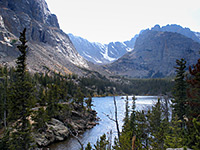
| Glacier Gorge | Like nearby Bear Lake, the Glacier Gorge trailhead is the gateway to the most spectacular yet accessible section of Rocky Mountain National Park. One path leads along Glacier Creek downstream towards Sprague Lake, and a short connecting path links with Bear Lake, but the main route follows the creek upstream, into the mountains. This splits into four - one branch is a long and difficult path that reaches the summit of Longs Peak after 9 miles, while the other three are one-way paths along very scenic valleys, each ending beneath a glacier, and all suitable for a day hike. After the whitewater cascade of Alberta Falls, the first junction (after the Long Peak Trail) is reached at the 2 mile point; from here the southernmost branch enters Glacier Gorge itself, a deep, straight, steep-walled ravine containing several beautiful lakes including Mills and Black. Back at the junction, another path heads northwest towards Lake Haiyaha and eventually to the Bear Lake trailhead, while a third branch climbs along a tributary of Glacier Creek (Brook Creek) to The Loch, surely one of the prettiest subalpine lakes in the area owing to its shallow, reflective waters, the unusual rocky shoreline, and the towering mountains all around. Not far after here, the path forks once more; one branch passes Timberline Falls to Lake of Glass and Sky Pond, the other ends at turquoise-colored Andrews Tarn at the base of Andrews Glacier. | ||
| Sprague Lake | 2.5 | 500 | |
Longs Peak |
9.0 |
5,000 |
|
Alberta Falls |
0.8 |
160 |
|
| Mills Lake | 2.8 | 750 | |
| Black Lake | 5.0 | 1,430 | |
The Loch |
3.0 |
990 |
|
| Lake of Glass | 4.6 | 1,600 | |
| Sky Pond | 4.9 | 1,710 | |
Andrews Glacier |
5.3 |
2,510 |
|
| Lawn Lake | The Lawn Lake trailhead is located close to the junction of Old Fall River Road with US 34, just east of the large alluvial fan that poured out of Roaring River Canyon following flooding in July 1982. The trail heads north up this canyon and soon splits; the left branch climbs a wooded ridge to Ypsilon Lake (from where the Spectacle Lakes can be reached by some off-trail climbing) while the right fork follows the canyon further, climbing more steeply at the upper end, to a junction with a path from Lumpy Ridge, and soon after to Lawn Lake, at the treeline. It continues further into the stark granite landscape of the high mountains to the two Crystal Lakes (via a short spur path), and ends with yet more climbing to a fine viewpoint on a bench between two 13,500 foot summits in the Mummy Range (The Saddle). | ||
| Ypsilon Lake | 4.5 | 2,180 | |
| Spectacle Lakes | 5.2 | 2,800 | |
Lawn Lake |
6.2 |
2,249 |
|
| Crystal Lake | 7.6 | 2,900 | |
| The Saddle | 8.2 | 3,660 | |
| Lily Lake | Right next to highway 7, Lily Lake is one of the easiest-reached lakes in the park, and has a scenic setting with Longs Peak rising high above, several miles to the south. An easy half mile trail circles the lake, and another short path climbs a ridge just to the north, but the one long distance route heads southwest to a highpoint of 10,260 feet at Storm Pass, where another path reaches the summit of Estes Cone, a conical extinct volcano. At the pass, continuation trails link with the Longs Peak and Storm Pass trailheads. | ||
| Storm Pass | 2.9 | 1,320 | |
| Estes Cone | 3.6 | 2,060 | |
| Longs Peak | The highest mountain in the park - 14,259 foot Longs Peak - may be reached by a long and strenuous trail of which the last 1.5 miles is more of a scramble over a steep boulder field, with several sections where the land falls away almost vertically at one side. Two campsites provide overnight stopping places en route, though the 16 mile round trip is quite possible for fit hikers in one day. Various other locations are reachable by shorter hikes including Eugenia Mine, Estes Cone, Chasm Lake, Columbine Falls and Peacock Pool, and even a short hike up the mountain affords excellent views. Granite Pass marks the junction with an alternative route to the summit, via a slightly longer path starting from the Glacier Gorge trailhead. | ||
| Eugenia Mine | 1.4 | 500 | |
| Estes Cone | 3.3 | 1,700 | |
Chasm Lake |
4.2 |
2,360 |
|
Granite Pass |
4.5 |
2,770 |
|
| Longs Peak | 8.0 | 4,885 | |
| Lumpy Ridge | In the northeast corner of the national park, the Lumpy Ridge trailhead is reached via Devils Gulch Road, 1.5 miles from Estes Park. The main day hike destination is little Gem Lake, attractively enclosed by vertical cliffs. The surroundings have many unusual, eroded rock formations, seen especially via another path that penetrates further west along the sparsely wooded Lumpy Ridge to Balanced Rock. The Gem Lake Trail continues to Cow Creek, while a longer route heads up Black Canyon towards Lawn Lake in the distant Mummy Range. | ||
| Gem Lake | 1.6 | 1,100 | |
| Balanced Rock | 3.8 | 1,100 | |
Cow Creek |
4.6 |
1,100 |
|
Lawn Lake |
8 |
3,150 |
|
| Sandbeach Lake | Surrounded by a soft sandy shoreline, and situated in a shallow valley beneath many high, rocky peaks, Sandbeach Lake is a good destination for a day hike, one that sees little visitation. The trail starts next to Copeland Lake on the road to Wild Basin, ascending steeply for the first mile or so then less so as it heads due west, passing four primitive campsites and crossing two streams, before emerging from the forest by the north shore of the lake. | ||
| Sandbeach Lake | 4.5 | 1,970 | |
| Storm Pass | The Storm Pass Trail first crosses marshy Glacier Creek beside the Bear Lake Road then climbs over a wooded ridge into the very upper end of the Wind River valley, where a side trail forks off and follows the creek downstream, past a number of small ponds. The main path continues southeastwards, now climbing rather more steeply up to Storm Pass at 10,260 feet - a saddle between a volcanic summit just to the north (Estes Cone, reached by a short spur), and the much higher Battle Mountain further to the west. Beyond the pass, one path heads south to Eugenia Mine and the Longs Peak trailhead, while another winds around the lower slopes of the cone and descends to Lily Lake along highway 7. | ||
| Wind River | 1.2 | 300 | |
| Storm Pass | 4.1 | 1,460 | |
| Estes Cone | 4.8 | 2,200 | |
| Lily Lake | 7.0 | 1,460 | |
Eugenia Mine |
5.3 |
||
| Longs Peak TH | 6.7 | ||
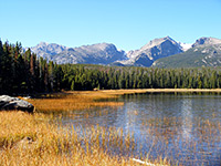
| Sprague Lake | Apart from the wheelchair-accessible, half mile path all around shallow Sprague Lake (reached via the Bear Lake road), several other short routes cross the flattish land to the east and west, running close to streams, ponds and small meadows; the two eventual destinations are Glacier Basin campground and a junction with the Storm Pass Trail. | ||
| Glacier Basin Cg | 1.2 | 100 | |
Storm Pass Tr |
0.7 |
120 |
|
| Twin Sisters | On the east side of the national park along highway 7, the Twin Sisters Trail climbs via many switchbacks to the two 11,400 foot summits of Twin Sisters Peaks. Most of the route is through quite thick forest but the last section is much more open; the summit has very wide ranging views over the Rockies and the flat plains of eastern Colorado. | ||
| Twin Sisters Peaks | 3.7 | 2,340 | |
| Upper Beaver Meadows |
The side road to Upper Beaver Meadows passes one picnic site and several pull-outs, and is a good, quiet route from which to look for wildlife including elk. It ends at a trailhead where one short path heads north over open, grassy land to US 36 and the start of a trail to Deer Mountain, while two others branch off to the south. The main route (Ute Trail) is a long path that follows a tributary of Beaver Brook upstream, crosses a ridge into Windy Gulch then climbs high above the treeline to the top of Tombstone Ridge, ending at a junction with Trail Ridge Road (US 34) at Ute Crossing. The third path leaves Beaver Meadows trailhead to the southeast and splits several times, all branches crossing mixed woodland and meadows in the general direction of the Moraine Park campground. | ||
| US 36 | 1.3 | 500 | |
Ute Crossing |
6.0 |
2,800 |
|
Moraine Park campground |
1.6 |
300 |
|
| Ute Crossing | One mile east of Forest Canyon Overlook along Trail Ridge Road, the Ute Crossing trailhead is the start of a lightly used path that climbs a little then crosses the top of a stark, rocky hill (Tombstone Ridge) to Timberline Pass, where it begins a lengthy descent into forested land and along several streams to the Upper Beaver Meadows trailhead. | ||
| Upper Beaver Meadows | 6.0 | 2,800 | |
| Wild Basin | Accessed by a side road off highway 7 in the southeast corner of the park, the Wild Basin trailhead is the start point for two long hikes to beautiful glacial lakes beneath several 13,000 foot peaks of the continental divide. The Wild Basin Trail first reaches two whitewater cascades (Copeland Falls and Calypso Falls), then splits; the south branch follows Ouzel Creek, soon climbing above the treeline to Ouzel Lake and the larger Bluebird Lake. The north branch ascends a little less steeply up the valley of St Vrain Creek, with a side trail passing the two small Castle Lakes and ending at Lion Lake No. 1 (No. 2 being 300 feet higher and reachable by off-trail hiking), while the main route continues to Thunder Lake, location of a primitive campsite. | ||
| Copeland Falls | 0.3 | 15 | |
| Calypso Cascades | 1.8 | 700 | |
| Ouzel Lake | 4.9 | 1,500 | |
| Bluebird Lake | 6.0 | 2,480 | |
Thunder Lake |
6.8 |
2,070 |
|
Lion Lake No. 1 |
7.0 |
2,565 |
|
All Contents © Copyright The American Southwest | Comments and Questions | Contribute | Affiliate Marketing Disclosure | Site Map