Trails in the West of Rocky Mountain National Park
Colorado > Rocky Mountain National Park > Trails in the West
Unlike most national parks where each trail leads to one specific destination, paths in Rocky Mountain NP typically reach several scenic spots - lakes, waterfalls, summits and viewpoints - and the paths intersect so many of the places can be accessed by more than one trail. Hence the trails are best summarized by the locations reachable from each trailhead, rather than trail name.
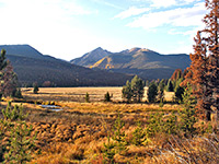
All trailheads in the west section of the national park are found along US 34, north of Grand Lake. The easiest routes are across Kawuneeche Valley and beside the Colorado River, while many more strenuous paths climb into the mountains, mostly on the east side of the valley. The relatively few popular destinations are (with trailhead) Lulu City (Colorado River), Adams Falls (East Inlet), Cascade Falls (North Inlet) and Big Meadows (Green Mountain).
See also the listing of trails in the east of the national park.
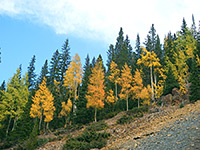
The Rocky Mountain National Park map indicates the location of all trailheads.
 |
|||
| Trailhead with selected destinations |
Length (one way) (miles) |
Elevation Change (feet) |
Trail Description |
| Bowen/Baker | After a short, level section across Kawuneeche Valley and the Colorado River, the path from the Bowen/Baker trailhead splits, with both branches soon exiting the park into the Arapaho National Forest and climbing to two high passes on the continental divide in the Never Summer Mountains - 11,476 foot Bowen Pass and 11,253 foot Baker Pass. | ||
| Bowen Pass | 10.0 | 2,610 | |
Baker Pass |
5.8 |
2,390 |
|
| Colorado River | The fairly level path along the upper Colorado River valley to the site of the former mining settlement of Lulu City provides an easy introduction to the scenery of Rocky Mountain National Park, although views are somewhat limited since much of the trail passes through thick woodland. After the townsite (of which the only remnants are the foundations of a few log cabins) the path continues another mile through the forest to a junction; the right fork has better views as it climbs rather more steeply up to a small summit (Little Yellowstone) where it meets a forest track that leads 1.3 miles further north to La Poudre Pass. The left branch follows the tributary stream of Lulu Creek all the way to 11,331 Thunder Pass, at the national park boundary. Another side trail runs along a scenic side valley (Skeleton Gulch) for 1.5 miles, until the cliffs become too steep to continue. Full hike description - Lulu City and Little Yellowstone |
||
| Lulu City | 3.1 | 300 | |
| Little Yellowstone | 5.2 | 1,230 | |
Thunder Pass |
6.5 |
2,320 |
|
Skeleton Gulch |
6.4 |
1,740 |
|
| Coyote Valley | The short Coyote Valley Trail crosses the Colorado River and runs alongside for a short distance, allowing a good appreciation of the scenic meadowland of Kawuneeche Valley, which is a good place to view wildlife, especially elk. | ||
| Colorado River | 0.5 | 40 | |
| East Inlet | Like the North Inlet Trail, the path starting at the East Inlet trailhead on the shore of Grand Lake leads along a deep valley far into the high mountain backcountry, passing several beautiful lakes near the continental divide. Most people though just walk for a few minutes up the trail to Adams Falls, since the first lake (Lone Pine) is not reached for another 5 miles. The others follow in fairly quick succession: Verna, Spirit and Fourth Lake, at the far upper end of the canyon beneath Isolation Peak. | ||
| Adams Falls | 0.3 | 80 | |
| Lone Pine Lake | 5.5 | 1,500 | |
| Lake Verna | 6.9 | 1,800 | |
| Spirit Lake | 7.7 | 1,900 | |
| Fourth Lake | 8.1 | 2,050 | |
| East Shore | Several paths cross the hillside on the east side of Shadow Mountain Lake and the Colorado River; the most used route follows the shoreline northwards for 1.5 miles then climbs to a lookout point on the westernmost of the two summits of Shadow Mountain, for a fine view over Grand Lake and the US 34 corridor. | ||
| Shadow Mountain | 5.2 | 1,500 | |
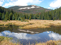
| Green Mountain | The Green Mountain trailhead marks the western end of the main path across the continental divide in Rocky Mountain National Park - it first climbs the east side of Kawuneeche Valley to Big Meadows along Tonahutu Creek, then follows the creek upstream for 6 miles, en route passing one waterfall (Granite Falls) plus many lesser cascades, and two junctions, the second with a 1.2 mile path to Haynach Lakes - several small ponds enclosed by rugged granite cliffs. The final few miles of the main route traverse smooth, treeless hillsides up to Flattop Mountain, where a continuation trail descends for 4.6 miles to the Bear Lake trailhead. | ||
| Big Meadows | 1.7 | 600 | |
| Granite Falls | 3.8 | 1,050 | |
| Flattop Mountain | 10.4 | 3,530 | |
Haynach Lakes |
7.8 |
2,270 |
|
| Kawuneeche | Starting right next to the visitor center at the Grand Lake entrance to the national park, a short trail leads eastwards along a shallow valley to Tonahutu Creek, joining the much longer route from the Tonahutu trailhead. | ||
| Tonahutu Creek | 0.8 | 100 | |
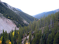
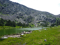
| North Inlet | North Inlet is one of the two main tributaries of Grand Lake, and it forms a long valley across the southwest section of the park. The trailhead may be reached by a short side road near the town of Grand Lake, from where the path first crosses an area of flat meadowland (Summerland Park) then begins its long ascent along the creek. The first point of interest, suitable for a half day hike, is Cascade Falls after 3.5 miles, beyond which the gradient gradually increases for another 4 miles to North Inlet Falls, near the only junction on the trail. From here both paths climb much more steeply; the south branch ascends the slopes of 12,324 foot Ptarmigan Mountain to two glacial lakes (Nokoni and Nanita), while the other leads up Hallett Creek to Flattop Mountain, a summit reachable rather more quickly starting from the Bear Lake trailhead. | ||
| Cascade Falls | 3.5 | 300 | |
| North Inlet Falls | 7.5 | 1,100 | |
| Lake Nokoni | 9.5 | 2,240 | |
| Lake Nanita | 10.5 | 2,280 | |
Flattop Mountain |
12.1 |
3,800 |
|
| Onahu | Beginning along US 34, four miles from the Grand Lake entrance to the national park, the Onahu Creek Trail follows one of the largest Colorado River tributaries as it flows down the hillsides north of Green Mountain. A junction is encountered after 3.4 miles; the left turn climbs quite steeply for a short distance to a flat marshy area (Long Meadows), from where 2 miles cross-country travel reaches another path, to Timber Lake. The other branch turns south, crosses a ridge and meets the Green Mountain Trail, thus allowing for a loop hike of 8 miles - once back at the Green Mountain Trailhead, another short path parallels the highway northwards back to Onahu. | ||
| Long Meadows | 4.2 | 1,470 | |
Green Mountain TH |
8.0 |
1,140 |
|
| Timber Lake | Right opposite the busy Colorado River trailhead, the less used path to Timber Lake is consistently steep as it climbs the forested hillside above Timber Creek, up to the source of the stream at a pretty lake beyond the treeline, close to the continental divide. There are several primitive campsites near the upper end of the path, and one side trail, which heads back along the far side of the valley to the source of a tributary stream, at Long Meadows. | ||
| Timber Lake | 4.6 | 2,060 | |
| Tonahutu | Just one path begins at the Tonahutu trailhead, on the north side of Grand Lake (close to North Inlet) - an easy, 4.2 mile route up the fairly narrow valley of Tonahutu Creek, past several primitive campsites to a junction with the Green Mountain Trail, joining 1.7 miles from its start point along US 34. | ||
| Green Mountain Tr | 4.2 | 960 | |
All Contents © Copyright The American Southwest | Comments and Questions | Contribute | Affiliate Marketing Disclosure | Site Map