Highlights:
12,095 foot pass in the central Rocky Mountains - the highest paved pass in Colorado - at the center of one of the most spectacular stretches of road in the state, between US 24 and Aspen, passing clear rivers, beautiful valleys, steep peaks and extensive aspen forests
Nearby town:
Leadville, 20 miles
Management:
The surroundings are USFS land - part of San Isabel and White River National Forests
Location:
Rating (1-5):
★★★★★
Seasons:
Late May to late October - the road is closed by snow at other times

Independence Pass is part of the Colorado Rockies itinerary
East of Aspen, Highway 82 climbs steadily next to the Roaring Fork River towards the Sawatch Range in the middle of the Rocky Mountains, and reaches a high point of 12,095 feet at Independence Pass, then descends into the even more beautiful valley of Lake Creek, eventually joining US 24 fifteen miles south of Leadville.
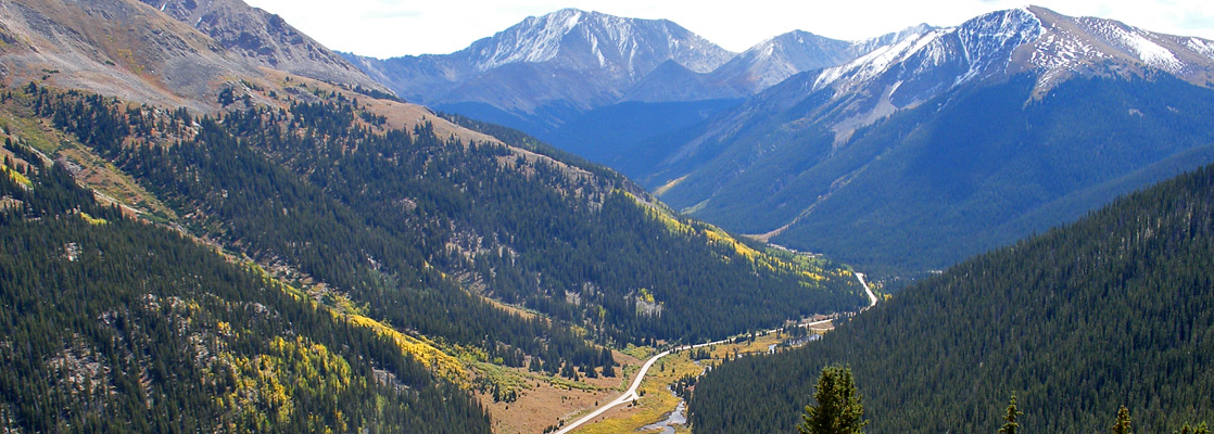
The scenery at the pass and all along the 44 mile route is some of the most spectacular in all Colorado, and perhaps the finest viewable from a major highway - the road runs right beneath many great mountains including the highest in the state (14,433 foot Mount Elbert), and rises well above the treeline into the stark Alpine tundra zone, while also passing lakes, rivers, steep-sided valleys, thick forests of fir and extensive aspen groves - so in fall, the yellowing leaves make the landscape even more colorful and photogenic.
Independence is the highest paved mountain pass in Colorado, though there are several higher unpaved passes (such as Mosquito and Cottonwood), while three paved roads climb further (Pikes Peak Highway, Mount Evans Byway, Trail Ridge Road in Rocky Mountain National Park), but these are not passes. Highway 82 is usually open for only six months of the year, from late May to late October, and the trip between Aspen and US 24 takes at least 90 minutes.
Independence Pass Table of Contents
- Map of Independence Pass
- Photographs
- East of the pass
- The pass
- West of the pass
- Nearby places
- Similar places
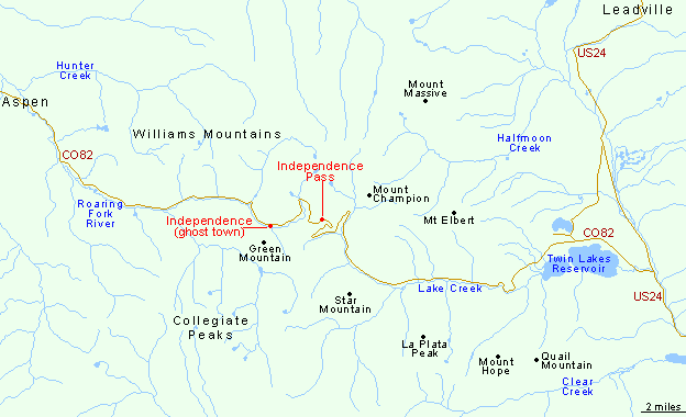
Map of Independence Pass and Highway 82
East of Independence Pass
Highway 82 across Independence Pass is best driven from east to west, since this direction offers the nicest views. In the east, the journey begins at the junction with US 24 in the upper Arkansas River valley, already at quite a high elevation of 9,100 feet. The first few miles parallel the north shore of Twin Lakes Reservoir - two scenic, interconnected lakes at the mouth of a narrow valley framed by several dramatic, snow-capped peaks beyond, attractively reflected in the calm waters. There are plenty of shoreline access points, and the lakes are popular for fishing, boating and picnicking. The highway rounds the marshy west end of the furthest lake and meets the inlet stream (Lake Creek), which it follows for the next 12 miles - through quite a straight valley, bordered by smooth-sided, wooded mountain slopes. To the right, the hills rise up to Colorado's highest peak Mount Elbert, on the opposite side is La Plata Peak, the fifth tallest in the state, and several other summits in view also top 13,000 feet. The highway passes two creekside campsites, in a forested part of the canyon, then moves into more open land and bends to the north, while still climbing only gradually, but soon begins a much steeper ascent as it bends back south, traversing an exposed slope at the head of the valley. Several long switchbacks take the road 1,300 feet higher over the next 4 miles to Independence Pass, which also marks the continental divide, the crest of the Sawatch Range, the Pitkin-Lake county line, and the boundary between the White River and San Isabel national forests.
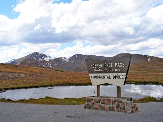
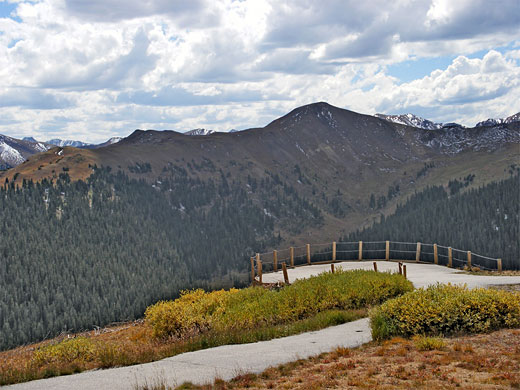
The Pass
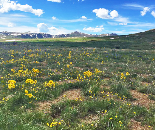
The land around the summit is flattish, windswept, lonely, and covered by sparse vegetation of grass and delicate tundra plants - the treeline is a thousand feet lower down - and yet all around are higher mountains, especially to the south and east. Several shallow pools line the road around the pass, and patches of snow are likely to remain for most of the summer. There are no visitor facilities at the summit, just a large carpark and a short, paved loop path leading to two overlooks of Lake Creek valley and surrounding peaks. A longer trail (2 miles) heads southwest, following the continental divide, to an unnamed peak 700 feet higher up.
West of Independence Pass
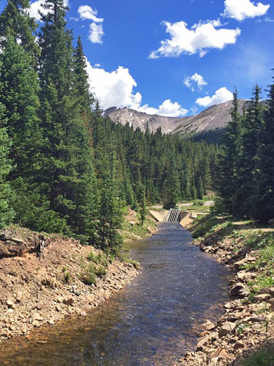
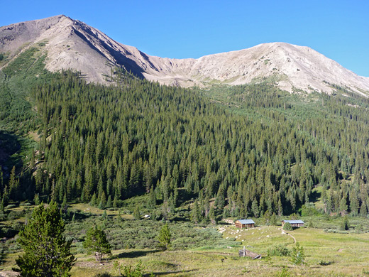
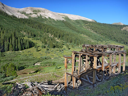
West of Independence Pass, highway 82 descends at an 6% grade across steep, barren slopes of rock and bare earth, through an area prone to landslides, and soon reaches the very upper end of Roaring Fork River, which is then followed through thick woodland for 20 miles, all the way to the ski resort town of Aspen. En route are various trailheads, national forest campsites and riverside parking areas plus one ghost town - Independence, a center for gold mining that was home to around 2,000 people during a brief boom period in the late 1800s. Relics include cabins on the valley floor and the wooden frame of Farwell Stamp Mill, right beside the road. This section of the highway is generally narrower (a one-lane road in a few places) and more bendy than east of the pass; partly because of the trees, the views are more restricted, starting a little way west of Independence, and the surroundings not quite so scenic.
Independence Pass - Nearby Places
- Florissant Fossil Beds National Monument (99 miles) - petrified sequoia stumps, many smaller fossils and an old homestead
- Maroon Bells (30 miles) - jagged red sandstone peaks in the Rocky Mountains south of Aspen
Independence Pass - Similar Places
- Pikes Peak Highway, Colorado - 19 mile scenic drive rising to 14,110 feet
- Trail Ridge Road, Rocky Mountain National Park - highest paved road in the USA
All Contents © Copyright The American Southwest | Comments and Questions | Contribute | Affiliate Marketing Disclosure | Site Map