High Peaks Trail, Pinnacles National Park
California > Pinnacles National Park > Hiking > High Peaks Trail
High Peaks Trail
The main route into the high mountains of Pinnacles National Park, passing through the center of the largest volcanic formations, around Hawkins Peak; excellent views for most of the way
Length: 6 miles
Elevation change: 1,500 feet
Difficulty: Moderate
Type: Loop. Other trails branch off, allowing for longer loop hikes
Usage: Medium
Season: All year; less popular in summer
Trailhead: Bear Gulch visitor center
Rating (1-5): ★★★★★
Elevation change: 1,500 feet
Difficulty: Moderate
Type: Loop. Other trails branch off, allowing for longer loop hikes
Usage: Medium
Season: All year; less popular in summer
Trailhead: Bear Gulch visitor center
Rating (1-5): ★★★★★

The best hike in Pinnacles National Park is a 6 mile loop that starts by climbing a wooded valley to a grand viewpoint of the central mountains then ascends further into the High Peaks, passing right through the pointed volcanic formations for which the area is renowned. The return route is down another ravine, past the calm waters of Bear Gulch Reservoir and back to the trailhead via one of the monument's famous talus caves.
The loop involves 1,500 feet of elevation gain then loss, and comprises all or part of four separate trails (Condor Gulch, High Peaks, Rim and Moses Spring - see hiking index). Late winter and spring are the preferred times for the hike, since summer and fall bring hot weather, and cause the surroundings to become generally brown and arid, without any of the wildflowers that grow profusely earlier in the year.
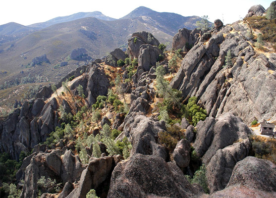
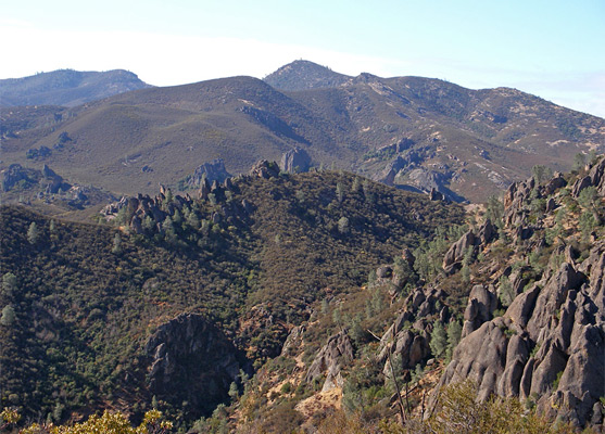
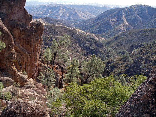
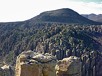
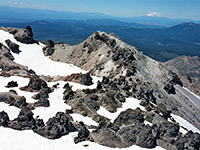
The walk begins at the Bear Gulch visitor center, on the east side of the national park, and is best followed in the anticlockwise direction since the main climb is done at the start. The Condor Gulch Trail heads northwest along one side of a tree-lined valley, staying nearly level for a while then becoming rather steeper, switchbacking up to an overlook of the ravine (a good destination for a short hike), from which the boulders and pinnacles of the main mountain range are visible. After the viewpoint, the path turns due east and winds around a ridge, as the land opens out and the undergrowth fades away. A little further is a junction with the High Peaks Trail, from where the right fork eventually meets the park road again after a gradual descent over 2 miles, while the left branch continues to the pinnacles; this climbs some more and soon passes several viewpoints of unusual volcanic rocks to the north including the Balconies and Machete Ridge - a smooth dome topped by a line of jagged boulders. Not far beyond, the path reaches the similar spires and boulders of the High Peaks, winding through many narrow crevices and small gullies between the smooth, coarse-grained breccia rock. California condors can often be spotted overhead, gliding around the peaks and valleys.
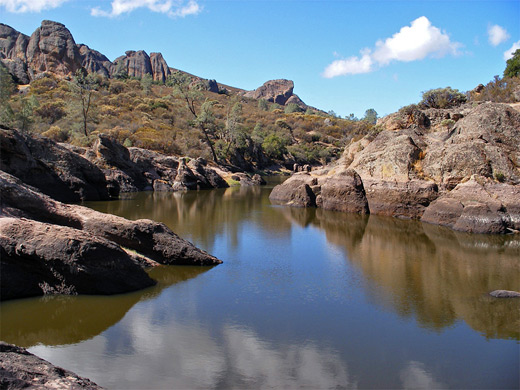
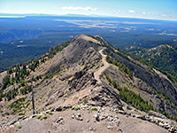
The trail splits into two, both branches crossing the summit though the left fork is more scenic and interesting than the right (the Tunnel Trail), first curving around the head of a steep valley then preceding past some of the largest pinnacles on the mountain, aided in places by various steps, ladders and metal walkways - a section known officially as the Steep and Narrow section. After a second junction, with the Juniper Canyon Trail, beneath a small summit that gives a nice 360 degree panorama, the route continues by descending steeply into another valley then more gently over relatively exposed, open hillsides to another fork. If walking straight on, the visitor center and the end of the hike is reached in 0.8 miles, but more interesting is the right path (the Rim Trail) that loops past the Bear Gulch reservoir and cave, arriving back at the trailhead after 1.6 miles. The reservoir is small but scenic, confined within black volcanic rocks, and makes a good location for a picnic. The canyon downstream provides the most popular climbing sites in the park, and a fine day at the weekend may see a dozen or more separate groups scaling the rocks.
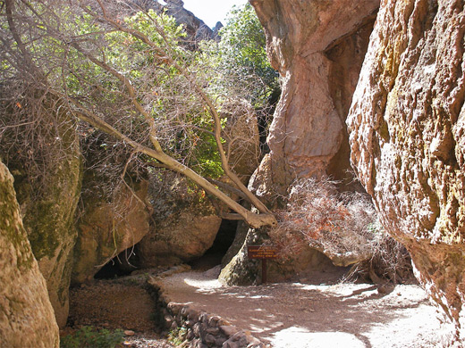
A regular trail leads from the reservoir down the side of the canyon to the visitor center, though more interesting is the parallel route along the streambed through the cave, which is formed by many huge boulders that long ago fell from the cliffs and became wedged in the narrow gorge. This path starts with a descent via many slippery steps then leads through a short cavern to an underground junction, offering an escape route before the start of the main cave, a series of cool, deep passageways that are completely dark for several sections of 20 yards or so, making a flashlight necessary. These may be borrowed free of charge from the visitor center. At some times of year (usually in summer) the trail is closed to protect a group of Townsend's big-eared bats that inhabit the cave. The creek flows close to the path though mostly out of sight, forming cold pools and hidden waterfalls. In the cave, steps and railings make the way quite safe, and after about 1/3 mile the path emerges quite suddenly into daylight, the remainder of the walk back to the carpark being along the Moses Spring Trail, down a sunny valley filled with bushes and sycamore trees.
The loop involves 1,500 feet of elevation gain then loss, and comprises all or part of four separate trails (Condor Gulch, High Peaks, Rim and Moses Spring - see hiking index). Late winter and spring are the preferred times for the hike, since summer and fall bring hot weather, and cause the surroundings to become generally brown and arid, without any of the wildflowers that grow profusely earlier in the year.
Condor Gulch and High Peaks Trails
The walk begins at the Bear Gulch visitor center, on the east side of the national park, and is best followed in the anticlockwise direction since the main climb is done at the start. The Condor Gulch Trail heads northwest along one side of a tree-lined valley, staying nearly level for a while then becoming rather steeper, switchbacking up to an overlook of the ravine (a good destination for a short hike), from which the boulders and pinnacles of the main mountain range are visible. After the viewpoint, the path turns due east and winds around a ridge, as the land opens out and the undergrowth fades away. A little further is a junction with the High Peaks Trail, from where the right fork eventually meets the park road again after a gradual descent over 2 miles, while the left branch continues to the pinnacles; this climbs some more and soon passes several viewpoints of unusual volcanic rocks to the north including the Balconies and Machete Ridge - a smooth dome topped by a line of jagged boulders. Not far beyond, the path reaches the similar spires and boulders of the High Peaks, winding through many narrow crevices and small gullies between the smooth, coarse-grained breccia rock. California condors can often be spotted overhead, gliding around the peaks and valleys.
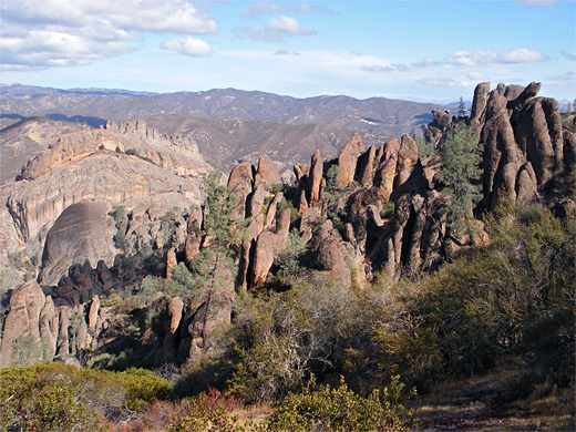
The High Peaks
The trail splits into two, both branches crossing the summit though the left fork is more scenic and interesting than the right (the Tunnel Trail), first curving around the head of a steep valley then preceding past some of the largest pinnacles on the mountain, aided in places by various steps, ladders and metal walkways - a section known officially as the Steep and Narrow section. After a second junction, with the Juniper Canyon Trail, beneath a small summit that gives a nice 360 degree panorama, the route continues by descending steeply into another valley then more gently over relatively exposed, open hillsides to another fork. If walking straight on, the visitor center and the end of the hike is reached in 0.8 miles, but more interesting is the right path (the Rim Trail) that loops past the Bear Gulch reservoir and cave, arriving back at the trailhead after 1.6 miles. The reservoir is small but scenic, confined within black volcanic rocks, and makes a good location for a picnic. The canyon downstream provides the most popular climbing sites in the park, and a fine day at the weekend may see a dozen or more separate groups scaling the rocks.
Bear Gulch Cave
A regular trail leads from the reservoir down the side of the canyon to the visitor center, though more interesting is the parallel route along the streambed through the cave, which is formed by many huge boulders that long ago fell from the cliffs and became wedged in the narrow gorge. This path starts with a descent via many slippery steps then leads through a short cavern to an underground junction, offering an escape route before the start of the main cave, a series of cool, deep passageways that are completely dark for several sections of 20 yards or so, making a flashlight necessary. These may be borrowed free of charge from the visitor center. At some times of year (usually in summer) the trail is closed to protect a group of Townsend's big-eared bats that inhabit the cave. The creek flows close to the path though mostly out of sight, forming cold pools and hidden waterfalls. In the cave, steps and railings make the way quite safe, and after about 1/3 mile the path emerges quite suddenly into daylight, the remainder of the walk back to the carpark being along the Moses Spring Trail, down a sunny valley filled with bushes and sycamore trees.
High Peaks Trail - Similar Hikes
All Contents © Copyright The American Southwest | Comments and Questions | Contribute | Affiliate Marketing Disclosure | Site Map