Hiking in Grant Grove, Kings Canyon National Park
California > Kings Canyon National Park > Grant Grove > Hiking
The Grant Grove Map shows the location of each trail.
See also the listing of trails for Kings Canyon, and the nearby Sequoia National Park.

Grant Grove Trails
|
Azalea Length 2 miles (3.2 km) Elevation change 900 feet (274 meters) Trailhead Grant Grove visitor center Rating (1-5) ★★★★★ South of the private enclave of Wilsonia, the Azalea Trail links CA 180 with Park Ridge; quite a steep ascent through mixed sequoia-pine forest along upper Sequoia Creek, which is flanked by many ferns and azaleas, the latter in bloom during midsummer. |
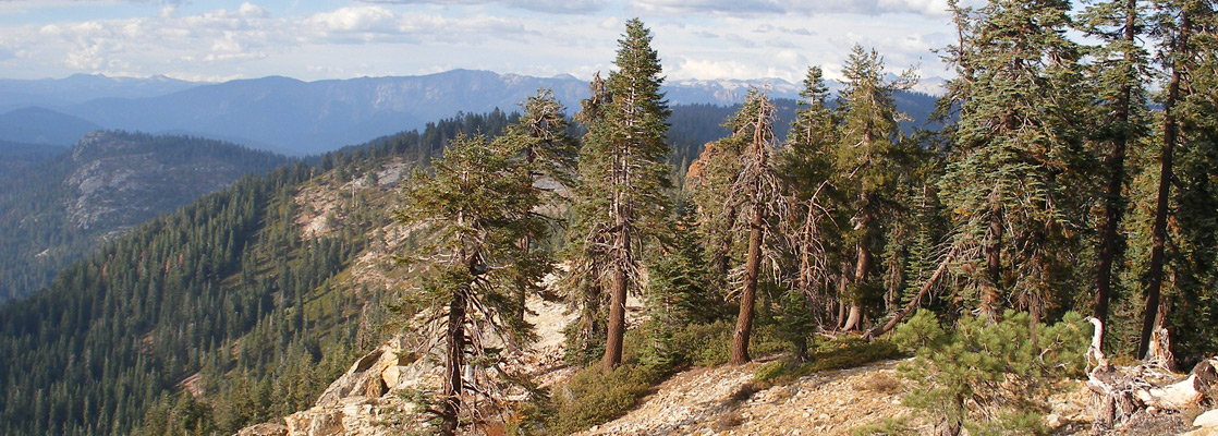
Big Baldy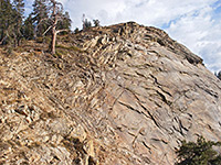 Length 2.2 miles (3.5 km) Elevation change 650 feet (198 meters) Trailhead Along Hwy 198, 6.6 miles south of the Hwy 180 junction Rating (1-5) ★★★★★ 8 miles from Grant Grove at the east edge of the national park, the route to the granite summit of 8,209 foot Big Baldy is along a well marked trail through pine forest interspersed by open areas. Views from the top encompass densely-forested Redwood Canyon to the west, Little Baldy to the south, and many higher peaks to the east, around the Jennie Lakes Wilderness Area and beyond. |
Big Stump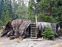 Length 2 miles (3.2 km) (loop) Elevation change 200 feet (61 meters) Trailhead Parking area beside the national park entrance station Rating (1-5) ★★★★★ Starting from the Big Stump entrance station on CA 180, this easy trail loops through a basin that was extensively logged in the 1880s but is now recovering after being added to the park in 1958 and so protected from any more commercial activity. Several short spur paths lead to particular stumps and fallen trees bearing evocative names such as Sawed Tree, Burnt Monarch and Shattered Giant. |
Buena Vista Peak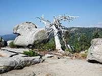 Length 0.8 miles (1.3 km) Elevation change 420 feet (128 meters) Trailhead Along the Generals Highway (CA 198), 4.7 miles from the CA 180 junction Rating (1-5) ★★★★★ This faint trail leads from a small parking area a little way south of Kings Canyon Overlook, on the Generals Highway southeast of the main Grant Grove area, to a treeless, granite summit that has a 360 degree view over the surrounding forest, mountains and canyons. |
Converse Basin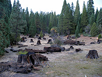 Length 1 miles (1.6 km) Elevation change 30 feet (9 meters) Trailhead Along FR13S55, 4.7 miles from Hwy 180 Rating (1-5) ★★★★★ A few miles north of Grant Grove, in Giant Sequoia National Monument, Converse Basin once contained the most extensive grove of sequoias anywhere in the Sierras but was almost completely cleared in the early 20th century. A network of dirt tracks criss-crosses the basin, and from one begins a shady trail to Boole Tree, one of the few remaining old-growth sequoias, and today recognized as the 8th largest in the world. Amongst the new pine trees are many huge stumps from the felled sequoias. |
General Grant Tree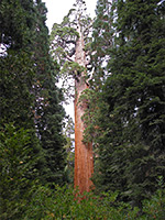 Length 0.3 miles (0.5 km) (loop) Elevation change 30 feet (9 meters) Trailhead Grant Grove Rating (1-5) ★★★★★ The paved, wheelchair accessible, self-guiding path to General Grant, the 3rd largest tree on Earth, begins 1 mile northwest of the Grant Grove visitor center, and also passes numerous other large trees with official names. This is the one must-do trail in Grant Grove if time is limited. The path is reached by a short, paved side road, that descends a little to a large parking area. |
|
North Grove Loop Length 1.5 miles (2.4 km) (loop) Elevation change 300 feet (91 meters) Trailhead Grant Grove Rating (1-5) ★★★★★ North Grove is a group of trees in a less-visited part of the forest, on a west-facing hillside above a tributary of Mill Flat Creek. The sequoias here are mixed with pine trees, meadows and small streams, and are visited by an easy trail along an old logging track. The starting point is at the end of the short side road also used for the General Grant Tree trail. |
Park Ridge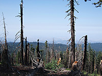 Length 2.3 miles (3.7 km) Elevation change 200 feet (61 meters) Trailhead Parking area at Panoramic Point Rating (1-5) ★★★★★ Beginning at the end of the paved, 2.3 mile side road to Panoramic Point, this trail follows Park Ridge southwards, ending at a fire lookout point at 7,530 feet. The trees are regular pine and fir, but the attraction of the hike is the panoramic view in all directions. A forest road provides an alternative route back to the trailhead. |
|
Redwood Canyon Length 16 miles (25.7 km) Elevation change 1400 feet (427 meters) Trailhead Along the track to Redwood Mountain Grove Rating (1-5) ★★★★★ Two loops and a spur trail lead into the steep-sided valley of Redwood Creek, the only part of the Grant Grove area suitable for backpacking, though only for a maximum stay of 2 nights. Despite the name, the canyon contains sequoias rather than redwoods, mixed with other trees, open meadows and small creeks. |
Sequoia Lake Overlook/Dead Giant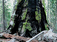 Length 2.2 miles (3.5 km) Elevation change 200 feet (61 meters) Trailhead RV parking area at General Grant Grove Rating (1-5) ★★★★★ From the General Grant Tree parking area, the Sequoia Lake Overlook trail heads southwest, descending gradually through the forest to an overlook of the lake, located just west of the national park boundary on private land. On the way the path passes the remains of a large sequoia that was felled many years ago. |
Sunset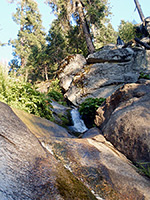 Length 3 miles (4.8 km) Elevation change 1140 feet (347 meters) Trailhead Grant Grove visitor center Rating (1-5) ★★★★★ The Sunset Trail starts from the Grant Grove visitor center and heads west into the forest, winding down the hillside above Sequoia Creek as far as the national park boundary, just east of Sequoia Lake. En route are a wide variety of plant species, including sequoias on the upper slopes, and a small waterfall along the creek (Ella Falls). Other trails allow for loop hikes, including Dead Giant/Sequoia Lake Overlook (5 miles total). |
All Contents © Copyright The American Southwest | Comments and Questions | Contribute | Affiliate Marketing Disclosure | Site Map