Roads & Sites in the East of Joshua Tree National Park
California > Joshua Tree National Park > Roads & Sites in the East
Highlights:
The eastern section of Joshua Tree National Park, the Sonoran Desert - lower in elevation than the west, mostly wide basins and plains with scattered mountain ranges. Few Joshua trees but many other desert plants. Trails lead to summits, old mines and palm oases

The eastern, lower elevation section of Joshua Tree National Park is generally emptier than the west, with few or no Joshua trees; the scattered vegetation is mostly cacti and small bushes, since the land is part of the Sonoran Desert rather than the Mojave Desert.
Trails lead to summits, old mines and palm oases. Pinto Basin Road crosses from north to south, exiting the park near Interstate 10 (exit 168), but most of the eastern section of the preserve is essentially roadless, and rarely visited.
Trails lead to summits, old mines and palm oases. Pinto Basin Road crosses from north to south, exiting the park near Interstate 10 (exit 168), but most of the eastern section of the preserve is essentially roadless, and rarely visited.
Table of Contents
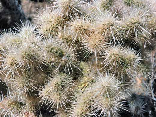
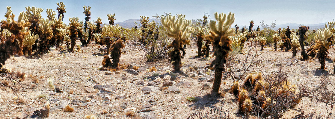
Cholla Cactus Garden
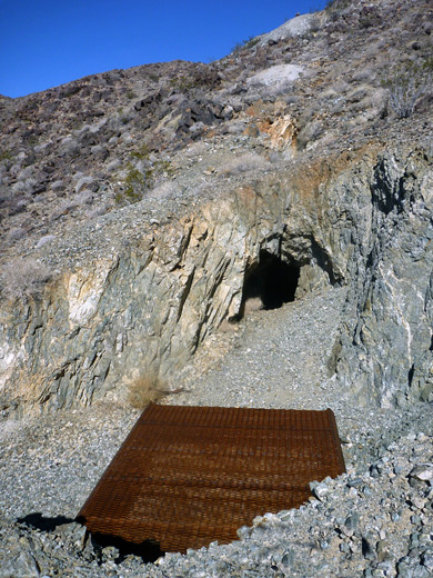
Half way along the main road across Joshua Tree National Park, the Cholla Cactus Garden (elevation 2,160 feet) marks the approximate boundary with the Sonoran Desert, which is hotter and has less rainfall than the Mojave. Although teddy bear cholla (cylindropuntia bigelovii) are widespread across desert regions of Arizona and California, this location has a particularly dense collection where the plants grow very close together, almost to the exclusion of all other species - only the occasional creosote bush or echinocereus are also seen. A quarter mile loop trail winds through the cholla, whose long spines show a range of colors from cream-white on the newest growth to brown and black on old or dead specimens. Many fallen pads litter the ground, creating a potential hazard when walking, as they will attach themselves to skin or clothing at the slightest contact. Two miles west of the cactus garden, a roadside pull-out marks the start of the mostly off-trail walk to Silver Bell and El Dorado mines.
Pinto Basin
East of the cholla, at lower elevations, ocotillo plants are quite abundant, but generally from here to the south entrance vegetation is sparse and there is not much to see. The scenery is impressive enough though no different to dozens of other desert mountain ranges in south California and neighboring Arizona. About one third of the national park lies away from the highway even further east, containing the flat Pinto Basin and the remote Coxcomb Mountains - and is an officially designated Wilderness Area. This land is traversed by only a few, low quality, dirt roads, which lead to abandoned mine workings and water wells. The dominant plant is the ubiquitous creosote bush, widespread across all Southwest states - these plants grow at quite widely-spaced intervals to make best use of the scarce water, giving the landscape a uniform, specked appearance from afar. Just beyond the southeast park boundary, in the Eagle Mountains, a recent agreement has given the go-ahead for construction of what may become the world's largest landfill site, despite much opposition from local conservation groups.
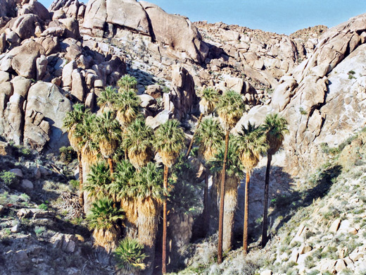
Cottonwood Spring
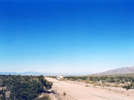
Close to the south entrance, the one main location of interest in the Sonoran Desert section of the park is at Cottonwood Spring, site of one of Joshua Tree's six fan palm oases, near which is a campground, ranger station, visitor center, picnic area, nature trail, an old gold mine on Mastodon Peak, and the start of a 4 mile path to the Lost Palms Oasis. Beyond this maintained trail are rougher routes to the two most remote oases in the park, Victory Palms and Munsen Canyon. The final few miles of the Pinto Basin Road descend through the narrow Cottonwood Canyon between the Eagle and Cottonwood mountain ranges, ending at exit 168 of I-10, though another road continues southwards through Box Canyon towards Mecca and the Salton Sea. Just south of the interstate, the unpaved Pinto Road provides some nice places for free camping, far enough from the highway for a quiet night's sleep.
Joshua Tree Tours
Experience the backcountry by 4WD vehicle.
Trails in the East Joshua Tree
All trails in Joshua Tree NP.
Featured Joshua Tree East Trails
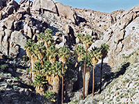
Lost Palms Oasis
★★★★★
★★★★★
4 miles, 450 feet
Perhaps the best day hike in Joshua Tree National Park, the route to the fan palm trees and pools at Lost Palms Oasis encounters rocky ridges, sandy washes, many Sonoran desert cacti and granite boulders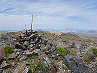
Pinto Mountain
★★★★★
★★★★★
4.5 miles, 2,200 feet (loop)
Mostly off-trail hike across sandy flats and up a ravine to an isolated summit in the north-central area of the park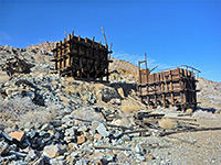
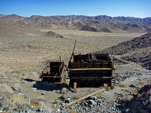
Silver Bell and El Dorado Mines
★★★★★
★★★★★
4 miles, 250 feet (loop)
These are two disused mines in the Hexie Mountains, visited by a moderate loop trail, partly cross-country; relics include two well-preserved wooden tipples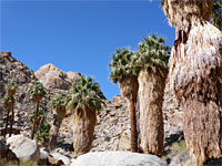
Victory Palms and Munsen Palms
★★★★★
★★★★★
5.4 miles, 450 feet
Backcountry palm oases, beyond the end of the Lost Palms Oasis Trail; the small Victory Palms, and several larger groups extending 1.6 miles along Munsen CanyonAll Contents © Copyright The American Southwest | Comments and Questions | Contribute | Affiliate Marketing Disclosure | Site Map