Arizona National Forests
Other Arizona listings: national parks and monuments, state parks and national wildlife refuges.
Formerly two separate national forests, Apache and Sitgreaves were combined in 1974 and form an continuous block of public land extending for 200 miles across the mountains of east Arizona. The Sitgreaves section includes the Mogollon Rim near Heber and Show Low, a region of pine forests, lakes, rivers, valleys and sandstone cliffs. Further east, the Apache section of the national forest is equally varied, especially in elevation which ranges from over 11,000 feet near Mount Baldy to 3,500 feet near Clifton. Highway 191 (the Coronado Trail) crosses right through the White Mountains that make up most of this area, and is one of the most scenic drives in the state. |
|
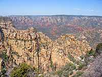
Coconino, the third largest national forest in Arizona (1.85 million acres) extends over a scenic area of mountains, plateaus and canyons around the Mogollon Rim in the center of the state - features include the San Francisco Peaks north of Flagstaff, the adjacent San Francisco volcanic field, Oak Creek Canyon, the red rocks of Sedona and several forested lakes of which the largest is Mormon Lake, south of Flagstaff. Access is good - there are many tracks into the backcountry, and plenty of opportunities for camping, hiking, fishing, hunting and boating (on Lake Mary). Locations in or near the national forest include Sycamore Canyon, West Clear Creek and the wilderness north of Sedona. |
|
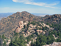
Twelve widely separated mountain ranges make up the 1.78 million acre Coronado National Forest in southeast Arizona (plus one section in New Mexico). Known as 'sky islands', these forested peaks are surrounded by arid desert at much lower elevations, and harbor many species of wildlife. The largest component is west of Sierra Vista and contains the Coronado National Memorial; other parts include the Santa Catalina Mountains east of Tucson and the Chiricahua Mountains enclosing Chiricahua National Monument. |
|
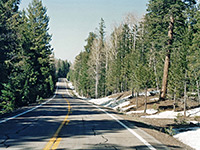
The three separate units of the Kaibab National Forest total over 1.5 million acres in north Arizona, and most of the area is densely wooded. The northernmost section covers the Kaibab Plateau on the North Rim of the Grand Canyon and is crossed by one paved road (AZ 67) and many logging tracks, though all this region is covered by thick snow for six months of the year. Some tracks lead to rarely seen viewpoints and tributaries of the canyon, including Kanab Creek and Snake Gulch. Another part of the forest borders the South Rim of the canyon, land which is tree-covered in the higher elevations near the rim but becomes flat and grassy further south. The third unit surrounds the city of Williams on I-40 and is more hilly, rising to a high point of 10,418 feet (Kendrick Peak). |
|
Prescott National Forest covers a large area of mountainous land in central Arizona, near such towns as Prescott, Cottonwood, Clarkdale and Camp Verde. The region includes all or part of eight wilderness areas, of which Granite Mountain is the most accessible, and has much interesting scenery, encompassing landscapes ranging from the Sonoran Desert through the chaparral and pine-juniper zones to ponderosa pine forests at the highest elevations. Major ranges are the Bradshaw, Juniper and Santa Maria Mountains west of Prescott, and the Black Hills south of Cottonwood. The national forest also contains much of the upper drainage basin of the Verde River. |
|
Tonto is the largest and most varied of the six national forests in Arizona, with terrain ranging from the cactus-covered Sonoran Desert around Phoenix, elevation 1,400 feet, to pine clad mountains along the Mogollon Rim, up to 7,400 feet. Highways 87, 188 and 260 are the main routes across the region, though most is rough and accessed only by 4WD tracks. The forest also includes rocky canyons, grassy plains, rivers and several artificial lakes including Bartlett Reservoir and Theodore Roosevelt Lake. Description and Map | Photographs |
All Contents © Copyright The American Southwest | Comments and Questions | Contribute | Affiliate Marketing Disclosure | Site Map