The American Southwest
Home | Parks | Trails | Plants | Canyons
Maps | Landscapes | Site Map | Whats New? |
More...
Follow americansouthwest.net on Facebook
×
General Pages
Home
Parks
Trails
Plants
Slot Canyons
Maps
Landscapes
Itineraries
Site Map
What's New?
More pages...

States
Arizona
California
Colorado
Idaho
Nevada
New Mexico
Oregon
Texas
Utah
Wyoming


ARIZONA
CALIFORNIA
COLORADO
IDAHO
NEVADA
NEW MEXICO
OREGON
TEXAS
UTAH
WYOMING
UTAH
MAPS | PARKS | TRAILS | HOTELS

Map of Golden Spike National Historic Park


Utah > Golden Spike National Historic Park > Map
Map of Golden Spike National Historic Park

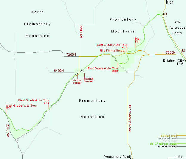
The entrance to Golden Spike National Historic Park is 26.5 miles along Highways 13 and 83, starting at junction 365 of I-15/I-84, near Brigham City. The northern approach, all along Hwy 83, is 16.5 miles from I-84 exit 26.

PDFPDF format maps, from the National Park Service:
Golden Spike NHP, transcontinental railroad

Back to Top
Arizona | California | Colorado | Idaho | Nevada | New Mexico | Oregon | Texas | Utah | Wyoming | Slot Canyons | Travelogue | SOUTHWEST

All Contents © Copyright The American Southwest | Comments and Questions | Contribute | Affiliate Marketing Disclosure | Site Map