Slot canyons of the Paria River and its tributaries.
The Paria River flows from the foothills of the Paunsaugunt Plateau near Bryce Canyon in south Utah to the Colorado River at Lees Ferry in far north Arizona. The lower end of the river from the state border southwards is now within the new Vermilion Cliffs National Monument. Paria is the main drainage in the western part of Grand-Staircase Escalante National Monument and while it has fewer good side canyons than the better known Escalante River system to the east, there are still plenty to explore. In particular, the Paria is famous for its tributary the Buckskin Gulch - the longest slot canyon in the world, cutting through the familiar red Navajo sandstone for some 12 miles. Near the confluence, the river also flows through a deep long section, and the multi day hike through here to Lees Ferry is, together with Zion Canyon Narrows, considered one of the two premier canyon hikes in the Southwest.
A few miles upstream of Buckskin Gulch, the Paria crosses US 89 and divides into various tributaries. The main canyon is not too interesting - it is deep and sheer-walled in many places but easy and level enough for 4WD vehicles to drive all the way to the head of the valley, exiting to UT 12 near Tropic. Side branches offer more excitement and variety; the two slots most often explored are Bull Valley Gorge and Round Valley Draw towards the north side of the region, but there are many other canyons with shorter narrows, less well known and harder to reach, such as Starlight and Booker canyons. The main thoroughfare across the region is the Cottonwood Canyon Road, which runs close to the Paria for a few miles at its southern end, then turns away alongside a lengthy, straight tributary (Cottonwood Wash), which has one short section of narrows right next to the road. Some of the west side Paria tributaries may be accessed by the Johnson Canyon - Skutumpah Road between Cannonville and US 89, though apart from the short narrows in Lick Wash, the interesting places are still quite far away, and need either a long hike or a drive on a 4WD track to reach.
Other Paria tributaries with slots, some of which have high dryfalls and hence require rappelling, are Asay Canyon, Deer Creek, Johnson Hole Canyon, Oak Creek, Rock Springs Creek and Stone Donkey Canyon.
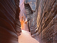
Booker Canyon
★★★★★
★★★★★
3 miles, 600 feet
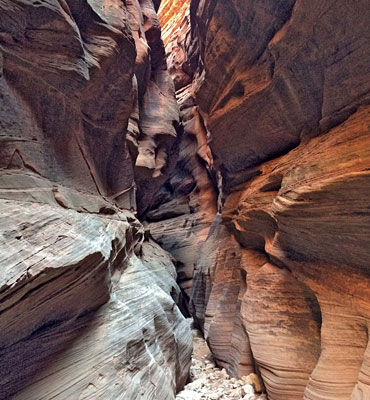
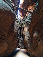
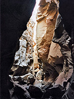
Short but pretty narrows in a remote, little-visited region; a tight, V-shaped slot that gives way to a deeper canyon through photogenic, angled, thin-layered rocksBuckskin Gulch
★★★★★
★★★★★
13.5 miles, 900 feet
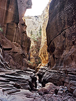
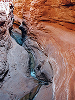
Longest and deepest slot canyon in the Southwest - intimidating, sheer-walled narrows that extend for 12 miles, meeting the Paria River in the middle of its own lengthy enclosed sectionBull Valley Gorge
★★★★★
★★★★★
2 miles, 500 feet
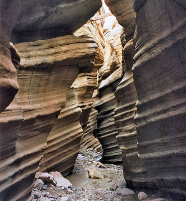
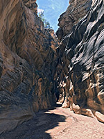
Good, deep narrows through colorful, thin-layered sandstone, containing long muddy pools and several dryfalls, hence quite testing to exploreCottonwood Wash Narrows
★★★★★
★★★★★
3.2 miles, 300 feet
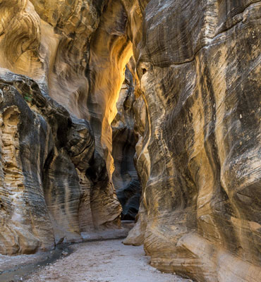
Short enclosed section of canyon running parallel to Cottonwood Canyon Road, through the angled strata of the CoxcombLick Wash
★★★★★
★★★★★
0.9 miles, 120 feet
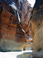
Brief narrows section enclosed by unusual thin-layered, cross-bedded sandstone; not especially colorful but interesting nonetheless, and quite photogenicParia River
★★★★★
★★★★★
7 miles, 300 feet
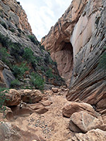
Rival of the Zion Narrows to be the best narrow, water-filled canyon in the Southwest - a usually shallow river flowing through miles of enclosed passageways between sheer cliffs up to 1,000 feet highRound Valley Draw
★★★★★
★★★★★
2.8 miles, 350 feet
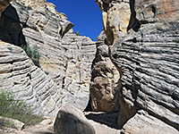
Deep, dark canyon through dull-colored sandstone, thin-layered in some places and nicely eroded. The narrows extend for about a mile, then the gorge gradually opens out and pine trees grow beside the streambedStarlight Canyon
★★★★★
★★★★★
5.8 miles, 500 feet
Short slot canyon in a remote location. Tributary of the Paria River, wide for most of its length, that forms a pretty, enclosed passageway containing a small stream, flowing through pools and cascadesWillis Creek
★★★★★
★★★★★
0.9 miles, 150 feet
Permanent stream flowing through some beautiful narrow sections, between curvy, nicely eroded walls streaked with desert varnishWire Pass
★★★★★
★★★★★
1.7 miles, 200 feet
Short tributary of Buckskin Gulch, used as an entrance route to that canyon, but forming a good, quite deep slot of its ownThe Paria River flows from the foothills of the Paunsaugunt Plateau near Bryce Canyon in south Utah to the Colorado River at Lees Ferry in far north Arizona. The lower end of the river from the state border southwards is now within the new Vermilion Cliffs National Monument. Paria is the main drainage in the western part of Grand-Staircase Escalante National Monument and while it has fewer good side canyons than the better known Escalante River system to the east, there are still plenty to explore. In particular, the Paria is famous for its tributary the Buckskin Gulch - the longest slot canyon in the world, cutting through the familiar red Navajo sandstone for some 12 miles. Near the confluence, the river also flows through a deep long section, and the multi day hike through here to Lees Ferry is, together with Zion Canyon Narrows, considered one of the two premier canyon hikes in the Southwest.
Other Paria tributaries with slots, some of which have high dryfalls and hence require rappelling, are Asay Canyon, Deer Creek, Johnson Hole Canyon, Oak Creek, Rock Springs Creek and Stone Donkey Canyon.
Related Sections
- Grand Staircase - Escalante National Monument - general information
All Contents © Copyright The American Southwest | Comments and Questions | Contribute | Affiliate Marketing Disclosure | Site Map