Lick Wash
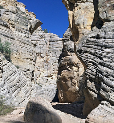
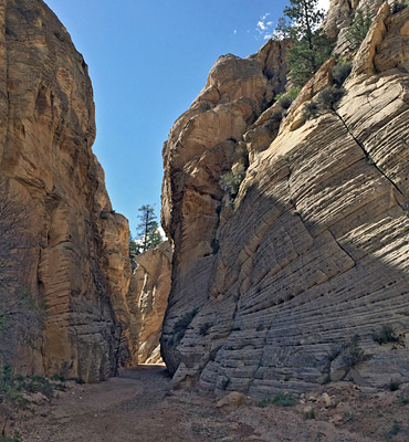
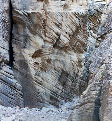
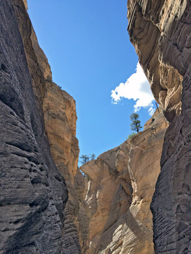
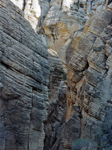
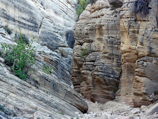
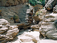
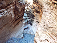
Brief narrows section enclosed by unusual thin-layered, cross-bedded sandstone; not especially colorful but interesting nonetheless, and quite photogenic
Length: 0.9 miles to the end of the narrows; 3.8 miles to Park Wash
Difficulty: Easy
Management: BLM - formerly part of Grand Staircase-Escalante NM
Rocks: Navajo sandstone
Season: Spring, summer, fall - during dry weather, else the access road may be impassable
Trailhead: Along Skutumpah Road, 20.5 miles south of Cannonville and 15 miles from Johnson Canyon Road
Rating (1-5): ★★★★★

A long drainage with just one short section of narrows, Lick Wash starts beneath the Pink Cliffs at the south end of Bryce Canyon and flows southeast, into Park Wash and then Kitchen Corral Wash, which becomes Buckskin Gulch south of US 89A. As with the gulch, the rocks around Lick Wash are Navajo sandstone but rather different to the deep red strata found downstream as here the cliffs are grey-brown, made of many thin, angled layers.
The narrows are close to an (unpaved) road so are easy to reach though the location is well away from main travel routes - most visitors are local ranchers who ride through to check on cattle grazing in pastures downstream.
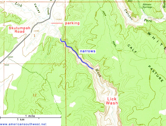
Lick Wash is reached by Skutumpah Road, the westernmost of three unpaved routes across the Paria-Escalante region, linking US 89 with UT 12. Like Smoky Mountain Road and Cottonwood Canyon Road, this is impassable in wet weather but should be suitable for all vehicles when dry. The drainage is about half way along - 18 miles from the north end of the road at the Paria River near Cannonville and 15 miles from the south end at the head of Johnson Canyon. The southern approach is preferred as the road is better; there is a good gravel surface, though still rather bumpy, for 13 miles as far as Deer Springs Ranch after which it is narrower and has some sections made of clay, apt to be rutted even when dry. Lick Wash flows across a wide basin (Dry Valley) 2 miles north of the ranch, and it is not signposted, though the hike has become more widely advertised by the BLM in recent years. Vehicles may be parked at a level area right next to the road bridge over the streambed. Past this point, the northern half of Skutumpah Road - also used to reach Bull Valley Gorge - is generally more uneven and rougher.
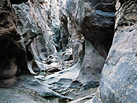
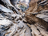
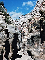
Cliffs rise up a short distance east of the road, enclosing the wash in a canyon that soon becomes 250 feet deep. It takes just ten minutes to walk down the stony creekbed to the start of the narrows - not quite a slot canyon as the walls are never less than around 15 feet across, Lick Wash still has several good enclosed sections through rocks composed of many bands of cross-bedded sandstone at different angles. There is an iron gate across the creek at one point, presumably to stop cattle, but no natural obstructions.
The narrows are close to an (unpaved) road so are easy to reach though the location is well away from main travel routes - most visitors are local ranchers who ride through to check on cattle grazing in pastures downstream.
Topographic Map of Lick Wash
Location
Lick Wash is reached by Skutumpah Road, the westernmost of three unpaved routes across the Paria-Escalante region, linking US 89 with UT 12. Like Smoky Mountain Road and Cottonwood Canyon Road, this is impassable in wet weather but should be suitable for all vehicles when dry. The drainage is about half way along - 18 miles from the north end of the road at the Paria River near Cannonville and 15 miles from the south end at the head of Johnson Canyon. The southern approach is preferred as the road is better; there is a good gravel surface, though still rather bumpy, for 13 miles as far as Deer Springs Ranch after which it is narrower and has some sections made of clay, apt to be rutted even when dry. Lick Wash flows across a wide basin (Dry Valley) 2 miles north of the ranch, and it is not signposted, though the hike has become more widely advertised by the BLM in recent years. Vehicles may be parked at a level area right next to the road bridge over the streambed. Past this point, the northern half of Skutumpah Road - also used to reach Bull Valley Gorge - is generally more uneven and rougher.
Lick Wash Route Description
Cliffs rise up a short distance east of the road, enclosing the wash in a canyon that soon becomes 250 feet deep. It takes just ten minutes to walk down the stony creekbed to the start of the narrows - not quite a slot canyon as the walls are never less than around 15 feet across, Lick Wash still has several good enclosed sections through rocks composed of many bands of cross-bedded sandstone at different angles. There is an iron gate across the creek at one point, presumably to stop cattle, but no natural obstructions.
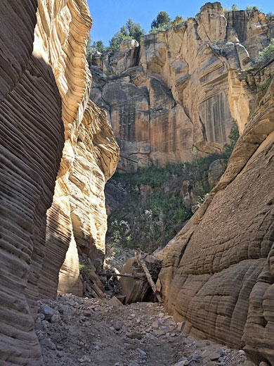
After the narrow passageways, the rocks become lighter in color as the gorge opens out, and ponderosa pine trees grow in alcoves at the edges, still quite a pretty scene. The canyon continues to deepen and widen for 2 more miles until it meets Park Wash, where the white walls of Navajo sandstone are 800 feet high, part of the White Cliffs of the grand staircase which are also seen in the upper end of Johnson Canyon when driving the southern approach route to Lick Wash. Although the narrows may be seen in only an hour, a full day could be spent walking to this point and exploring some of Park Wash.
Lick Wash - Similar Hikes
All Contents © Copyright The American Southwest | Comments and Questions | Contribute | Affiliate Marketing Disclosure | Site Map