Slot canyons in Death Valley National Park, California.
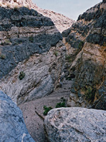
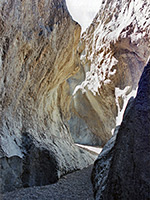
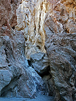
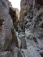
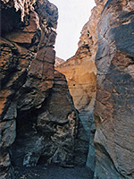
Death Valley is probably no different to many other desert basins in the Mojave region of California and Nevada in that the cliffs bordering the valley are drained by numerous narrow ravines, eroded by seasonal flash floods, that in places form slot-like passages. But because of the popularity of the national park the canyons in Death Valley have been explored much more than those in other locations. They are never normally very deep, are V-shaped rather than vertical-walled, rarely contain water for very long and tend to be quite steep, but the ravines here do share features common to the sandstone canyons of Arizona and Utah, including dryfalls, chokestones and pretty rock formations.
Within Death Valley, the best region for slot canyons seems to be Tucki Mountain, south of Stovepipe Wells village. Here are found Grotto Canyon, Mosaic Canyon, Stretched Pebble Canyon and Little Bridge Canyon, all quite close to CA 190, though others to the south and east are much further away from the highway. These canyons typically have many short enclosed sections ending beneath a dryfall, above which the drainage is temporarily more open. Most of the rest of the canyons along the west side of the valley are not near paved roads and can only be reached by either long cross country hikes, or by 4WD tracks.
The main park road runs along the east side of the valley, near to the edge of the mountains, so the canyons here are more accessible than those in the west, and as the hills are steeper, rising quite abruptly from the valley floor, the ravines become deep and sometimes narrow only a short distance from the highway. The southern third of Death Valley is bordered by the Black Mountains, the steepest of all the ranges, and while some of the ravines have narrows (Bad Canyon, Cerebus Canyon, Coffin Canyon, Hades Canyon, Styx Canyon, Willow Creek), they also have high dryfalls and can only be fully explored with ropes starting from the top, reached by driving along unpaved roads in adjacent Greenwater Valley.
The middle range of hills bordering the east side of Death Valley is the lower, slightly less rugged Funeral Mountains, north of Furnace Creek, which has generally wider drainages that are not so steep, as well as being several miles from the road so harder to reach. But one good place is Slit Canyon, accessed by the track to Red Ampitheater; this branches off CA 190 to the north, 2 miles west of Zabriskie Point. Slit Canyon has nearly one mile of narrow passageways through polished dolomite rock.
North of CA 134, the road through the top third of the valley runs alongside the Grapevine Mountains, which contain some of the longest narrows in the national park. Two with a road or trail through are Titus and Titanothere, while others with more slot-like sections include Fall Canyon (the best of all), Red Wall Canyon and Grey Wall Canyon.
Fall Canyon
★★★★★
★★★★★
4.5 miles, 1500 feet
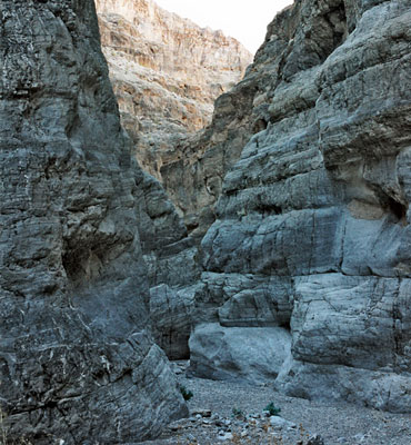
Major drainage that stays fairly wide but very deep for 3 miles until a 20 foot dryfall, above which are unusual and beautiful narrows through smooth, dark, marble-like strata, angled at about 30°Grey Wall Canyon
★★★★★
★★★★★
5 miles, 1000 feet
Long, twisting ravine through the northern Grapevine Mountains; shallow narrow passageways bordered by banded igneous rocks.Grotto Canyon
★★★★★
★★★★★
3 miles, 1200 feet
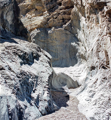
Perhaps the most beautiful narrows in Death Valley - a long succession of enchanting passages through light-colored rocks, often polished smooth by floodwaters. Many enclosed chambers, dryfalls and chokestonesRed Wall Canyon
★★★★★
★★★★★
4.5 miles, 2600 feet
Colorful wilderness gorge, deep in places, bordered by twisted, igneous rocks. Two sections of shady, moderately narrow passageways separated by a longer, open sectionSlit Canyon
★★★★★
★★★★★
1.8 miles, 900 feet
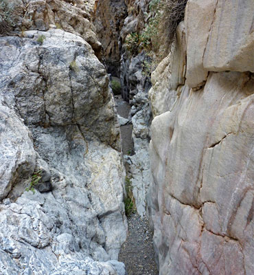
Twisting drainage through colorful rocks at the edge of the Funeral Mountains, near Hole-in-the-Wall a few miles from Hwy 190; contains dryfalls, chokestones, chutes and water-polished passagewaysStretched Pebble Canyon
★★★★★
★★★★★
2 miles, 1000 feet
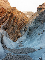
Minor, rarely-explored ravine on the west side of Tucki Mountain, with quite a steep upwards gradient, containing lengthy stretches of shallow narrows interrupted by frequent dryfallsDeath Valley is probably no different to many other desert basins in the Mojave region of California and Nevada in that the cliffs bordering the valley are drained by numerous narrow ravines, eroded by seasonal flash floods, that in places form slot-like passages. But because of the popularity of the national park the canyons in Death Valley have been explored much more than those in other locations. They are never normally very deep, are V-shaped rather than vertical-walled, rarely contain water for very long and tend to be quite steep, but the ravines here do share features common to the sandstone canyons of Arizona and Utah, including dryfalls, chokestones and pretty rock formations.
The main park road runs along the east side of the valley, near to the edge of the mountains, so the canyons here are more accessible than those in the west, and as the hills are steeper, rising quite abruptly from the valley floor, the ravines become deep and sometimes narrow only a short distance from the highway. The southern third of Death Valley is bordered by the Black Mountains, the steepest of all the ranges, and while some of the ravines have narrows (Bad Canyon, Cerebus Canyon, Coffin Canyon, Hades Canyon, Styx Canyon, Willow Creek), they also have high dryfalls and can only be fully explored with ropes starting from the top, reached by driving along unpaved roads in adjacent Greenwater Valley.
The middle range of hills bordering the east side of Death Valley is the lower, slightly less rugged Funeral Mountains, north of Furnace Creek, which has generally wider drainages that are not so steep, as well as being several miles from the road so harder to reach. But one good place is Slit Canyon, accessed by the track to Red Ampitheater; this branches off CA 190 to the north, 2 miles west of Zabriskie Point. Slit Canyon has nearly one mile of narrow passageways through polished dolomite rock.
North of CA 134, the road through the top third of the valley runs alongside the Grapevine Mountains, which contain some of the longest narrows in the national park. Two with a road or trail through are Titus and Titanothere, while others with more slot-like sections include Fall Canyon (the best of all), Red Wall Canyon and Grey Wall Canyon.
Related Sections
- Darwin Canyon - narrow ravine, waterfalls, pools and cascades
- Death Valley National Park - general information
- Mosaic Canyon - another narrow gorge, with marble-like rocks
- Natural Bridge Canyon - side valley containing a natural bridge
- Willow Creek - narrows, pools and waterfalls
All Contents © Copyright The American Southwest | Comments and Questions | Contribute | Affiliate Marketing Disclosure | Site Map