Sheep Rock Unit, John Day Fossil Beds National Monument
Oregon > John Day Fossil Beds National Monument > Sheep Rock
Highlights:
Largest of the three units of John Day Fossil Beds National Monument; eroded, bluish badlands along the John Day River with several fossil sites, plus a historic homestead. Explorable via seven trails
Location:

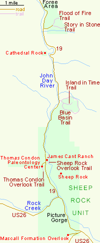
The largest and most visited of the three sections of John Day Fossil Beds National Monument is the Sheep Rock Unit, occupying several miles of the upper John Day River valley. US 26 crosses the south end of the monument, and for 2 miles runs right next to the river through a deep, enclosed canyon (Picture Gorge). Highway 19 forks off and follows the river northwards, passing several trailheads, overlooks, the visitor center/museum and an old ranch house.
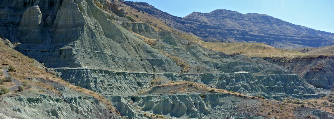
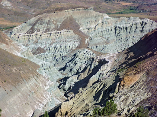
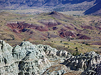
The valley at this point is quite wide, bordered by steeply sloping hillsides containing frequent outcrops of colorful rocks - deep red in a few places, like the badlands of the Painted Hills Unit, and bluish-grey in others. Many of the hills are topped by multiple layers of weathered black basalt, residues of ancient volcanic eruptions around 16 million years ago, and all the land is little vegetated, with trees found only along the river corridor.
The valley at this point is quite wide, bordered by steeply sloping hillsides containing frequent outcrops of colorful rocks - deep red in a few places, like the badlands of the Painted Hills Unit, and bluish-grey in others. Many of the hills are topped by multiple layers of weathered black basalt, residues of ancient volcanic eruptions around 16 million years ago, and all the land is little vegetated, with trees found only along the river corridor.
Sheep Rock Table of Contents
Map of the Sheep Rock Unit
Photographs
9 views of the Sheep Rock area, 16 views of the Blue Basin area.
James Cant Ranch and Visitor Center
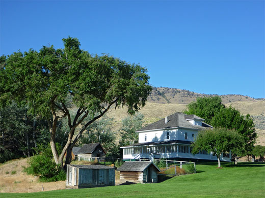
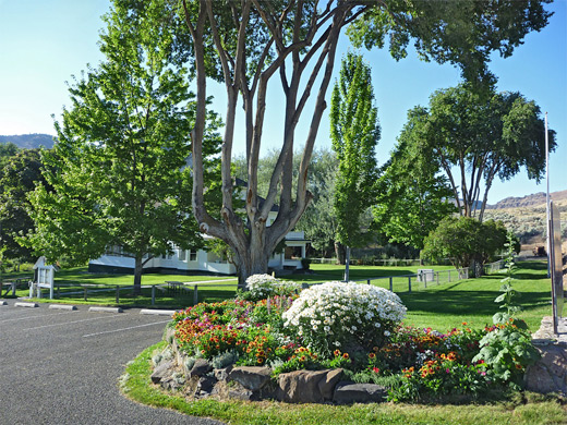
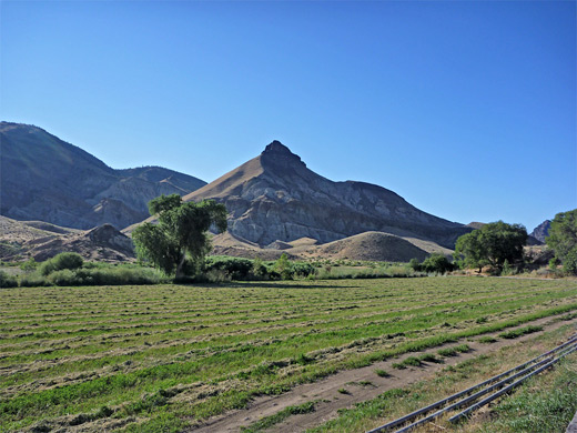
Driving north, the first site is James Cant Ranch, an elegant, three storey, white-painted wooded building, constructed in the early 20th century by Scottish immigrants James and Elizabeth Cant. The restored house now serves as the NPS headquarters and contains a small museum about the history of settlement in this remote, high desert area. Surrounding the ranch are extensive, well kept lawns, large trees, flowerbeds and various outbuildings including a large barn, open to visitors when the area is staffed. There is also a collection of old farm equipment, including wagons, plows and a hay stacker. Short paths lead to the river and to a viewpoint of Sheep Rock itself, a prominent summit rising above the east side of the valley, once home to a flock of big horn sheep. Opposite the ranch, Thomas Condon Paleontology Center contains a fossil museum, bookstore and park information center.
Sheep Rock Geological Sites
A little way north, the road reaches Blue Basin, the main hiking area, centered on a branched ravine through heavily eroded blue badlands. A three mile trail climbs high above and circles the whole area, while a shorter path enters the lower end of the ravine, passing several in situ fossils. For the next few miles the road crosses private land, passing a prominent, multi-layered cliff face (Cathedral Rock), which causes the John Day River to bend by 180°, then enters a smaller, detached section of the national monument, the Foree Area. This has a picnic area and two very short trails to viewpoints of cliffs and badlands; after here, Hwy 19 stays beside the river for many more miles, encountering similar arid scenery, and eventually reaches the tiny town of Fossil, from where the Clarno Unit of the monument is 16 miles southwest.
All Sheep Rock Trails
| Trail | Length (one way) (miles) |
Elevation Change (feet) |
Trail Description |
| Blue Basin Trail | 3 | 600 | The longest and best trail in the national monument climbs high above the eroded badlands of Blue Basin, giving spectacular views of the fractured ravines below, and of the John Day River valley |
| Flood of Fire | 0.25 | 50 | The Flood of Fire Trail ascends a bushy slope to a viewpoint on the edge of an eroded ravine, looking across the John Day River valley to the volcanic layers of Picture Gorge Basalt on the hills beyond |
| Island in Time | 0.8 | 200 | This, the most popular trail in the national monument, enters the lower end of a deep ravine through stark, eroded, blue-green claystone hills. En route are information notices and three in situ fossils |
| River | 0.3 | level | The wheelchair-accessible River Trail begins at James Cant Ranch and crosses a field to a viewpoint along the John Day River |
| Sheep Rock Overlook | 0.3 | level | This short path heads southeast from James Cant Ranch, ending at a riverside viewpoint below the eroded peak of Sheep Rock, formed of variegated layers of the John Day Formation |
| Story in Stone | 0.25 | 40 | From a parking lot at the end of a short side road in the Foree Area, this wheelchair-accessible trail climbs slightly across open land of small washes and bluish hills, to a viewpoint of eroded cliffs. Along the way are interpretative notices and exhibits, though no fossils |
| Thomas Condon Overlook | 0.25 | 40 | Beginning at the parking lot beside the Thomas Condon Paleontology Center, this easy path crosses a grassy hillside to a viewpoint looking up and down the John Day River valley |
Featured Sheep Rock Hike
Blue Basin and Island in Time Trails
★★★★★
★★★★★
3.8 miles, 600 feet
Tour of the spectacular Blue Basin badlandsAll Contents © Copyright The American Southwest | Comments and Questions | Contribute | Affiliate Marketing Disclosure | Site Map