Painted Hills Unit, John Day Fossil Beds National Monument
Oregon > John Day Fossil Beds National Monument > Painted Hills
Highlights:
Most photogenic of the three units of John Day Fossil Beds National Monument; beautiful yellow/red badlands and other eroded formations, viewed by a scenic drive and several short trails
Location:

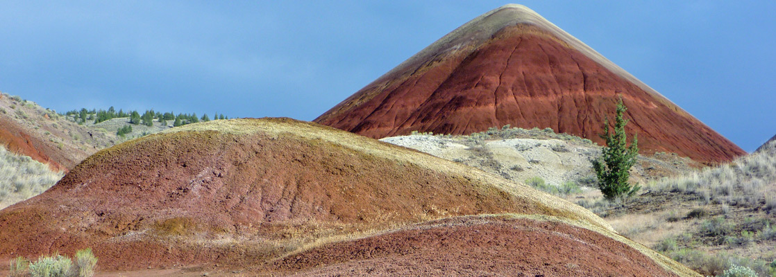
Sheep Rock is the largest section of John Day Fossil Beds National Monument, and Clarno has many in-situ fossils, but by far the most visually enticing location is the Painted Hills Unit, occupying a 3 by 3 mile area of badlands, hills and small ravines west of Bridge Creek, a minor tributary of the John Day River. The preserve contains just one fossil site, the unremarkable Leaf Hill; instead the main attractions are the incredibly colorful outcrops of exposed sandstone and claystone, either isolated mounds rising above flat grassland, or more extensive bands at the base of larger hills.
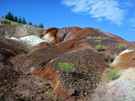
Red is the dominant color, mixed with shades of orange and gold, while in other places the earth is bright yellow, speckled with black patches that form downwards streaks due to the effects of rain and weathering. These variegated layers are from the lower John Day Formation, the bright shades being due to embedded volcanic ash. Although small in extent, the painted badlands are one of the most unusual and photogenic landscapes in Oregon, well worth the rather long drive needed to get there; for many miles the surroundings are rolling, grassy hills, well away from any large towns or other scenically interesting places.
Red is the dominant color, mixed with shades of orange and gold, while in other places the earth is bright yellow, speckled with black patches that form downwards streaks due to the effects of rain and weathering. These variegated layers are from the lower John Day Formation, the bright shades being due to embedded volcanic ash. Although small in extent, the painted badlands are one of the most unusual and photogenic landscapes in Oregon, well worth the rather long drive needed to get there; for many miles the surroundings are rolling, grassy hills, well away from any large towns or other scenically interesting places.
Painted Hills Table of Contents
Photographs
23 views of the Painted Hills area.
Approach to the Painted Hills
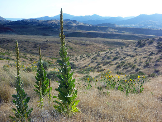
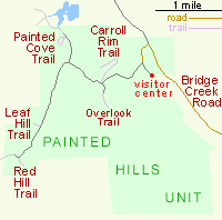
The Painted Hills lie 5.5 miles north of US 26 along Bridge Creek Road, also known as Burnt Ranch Road, the intersection being 72 miles west of John Day and 43 miles northeast of Prineville. The quiet backcountry road heads up a peaceful, little developed valley, passing a few places suitable for free primitive camping, becomes unpaved after the turning for the national monument, then reaches the John Day River after another 7 miles. The paved road leads to the visitor center, which is sometimes unstaffed, but maps and brochures are available outside; as with the other two units, no entrance fee is charged. Nearby is a nice picnic area, on a shady lawn close to the creek, while to the west a 3 mile gravel track winds through the badlands, passing trailheads for five short paths. Off trail hiking is not permitted, so opportunities for close-up viewing of the landscape are limited, but there are some quite good red-white banded hills a little way south of the national monument, on the east side of Bridge Creek Road, reachable by a 5 minute walk. Other similar areas can be seen further afield, along US 26.
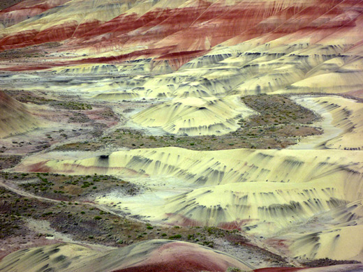
The Painted Hills
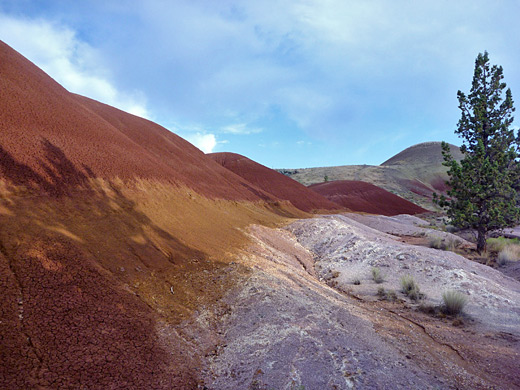
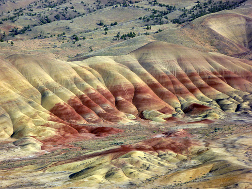
The best and largest area of badlands - the Painted Hills - are south of the track, close to the visitor center, and may be seen either from roadside pull-outs, or better from the 0.2 mile Overlook Trail, starting at the end of a spur road. The path climbs gradually along a ridge to a viewpoint on the west side of the hills, looking down across a beautiful mix of reds, yellows and golds. This point is good for a (relatively) close up perspective, but a better overall view is provided by the 0.8 mile Carroll Rim Trail, beginning just opposite. This ascends 400 feet to a flat-topped summit, but walking just a short way achieves enough elevation gain for a fine vista over all of the Painted Hills, the park road, and across to Bridge Creek valley. There are several benches along the way. The colors of the hills are of course more intense at sunset, and also when the ground is damp. The land has low relief - the hillsides are smooth, and gently undulating, without any rocky outcrops, so again the shadows of morning and evening help add some definition, making for better photographs.
Painted Cove, Leaf Hill and Red Hill
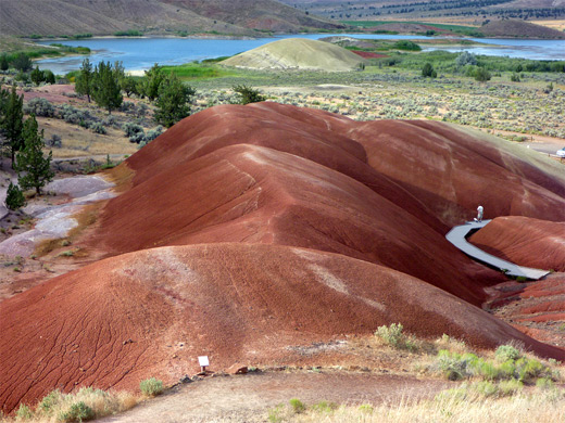
The road descends slightly and reaches a second junction, with the short road to Painted Cove, where a 0.2 mile, partly boardwalk trail loops through the middle of a small group of red mounds. The road continues outside the national monument onto private land, past a reservoir and close to other colorful hills. For about 150 feet the trail runs right through the reddish earth, so the scene consists of just three elements - the path itself, the uniformly deep red hills, and the (usually) blue sky above. The far side of the loop parallels the edge of the hills, which are lined by layers of brown and pink, while further west the land reverts abruptly to its normal grass-covered appearance. Back on the main road, the next site is Leaf Hill, toured by another 0.2 mile loop trail. The hill is formed of fragmented, very thin-layered sandstone, and thousands of leaf fossils have been excavated, but as the actual mound is off-limits, and no fossils can be seen in situ, the place is not so interesting. Just before the west edge of the national monument, the road arrives at Red Hill, then continues into more private land. The hill is well named, contrasting greatly with the much less colorful surroundings, and may be seen close-up via a very short path.
All Contents © Copyright The American Southwest | Comments and Questions | Contribute | Affiliate Marketing Disclosure | Site Map