City of Rocks National Reserve has a good variety of trails, many of which intersect, around the central area of granite formations known as the Inner City. Most popular of the short routes are the Bath Rock, Creekside Towers, South Fork Circle Creek and Window Arch trails, while the best extended hike is along the North Fork of Circle Creek, part of an 8 mile loop in combination with several other trail segments.
The City of Rocks map shows the location of all trails.
 |
|||
| Trail | Length (one way) (miles) |
Elevation Change (feet) |
Trail Description |
| Bath Rock Trail | 0.3 (loop) | 100 | This easy path loops around a large, isolated granite outcrop, which supports some long-lasting water tanks on top, reachable by careful off-trail scrambling. There are good, long distance panoramas to the south and east. |
| Box Top Trail | 1.8 | 300 | The Box Top Trail descends through a group of rock formations to the South Fork of Circle Creek then continues north to the Center Fork and ends at a 4-way junction with the Stripe Rock and Bumblie Wall trails. Besides the granite, the path also has wide ranging views of open grasslands to the east. |
| Bumblie Wall Trail | 0.6 | 100 | This connector path links the Box Top and North Fork Circle Creek trails, winding through narrow gaps between many huge rocks, passing several renowned climbing locations. |
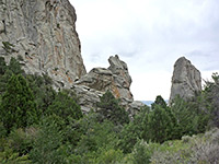
| Creekside Towers Trail | 0.5 | 150 | One of several routes starting at the Bath Rock parking area, the Creekside Towers Trail heads north along a cool, overgrown valley lined by near-vertical cliffs, an area known as the Inner City. A stream flows in spring an early summer, fed by several cascades. The north end of the trail is at Parking Lot Rock. |
| Flaming Rock Trail | 0.4 | 200 | From campsite no. 32, the Flaming Rock Trail descends gradually down a ravine between two lines of cliffs, to an intersection with the South Fork Circle Creek Trail. The path is mostly used by rock climbers. |
| Geo Watt Trail | 1.1 | 200 | The Geo Watt Trail forks off the Stripe Rock Loop, passing some isolated granite formations towards the north side of Circle Creek valley. |
| Indian Grove Trail | 1.2 | 500 | The lightly-used Indian Grove Trail branches off the North Fork Circle Creek Trail, crossing high elevation terrain to a sheltered, wooded valley, location of a backcountry campsite. It continues to a junction with the Skyline Trail. |
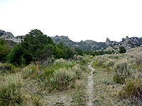
| North Fork Circle Creek Trail | 5 | 800 | The longest trail in the City of Rocks winds through many granite spires and pinnacles at its lower elevations, and a mix of sagebrush flats, grassland and aspen groves higher up. The path can be combined with parts of the South Fork, Creekside Towers, Stairways, Bumblie Wall and Stripe Rock trails to form an 8 mile loop, the best extended hike in the national preserve. |
| South Fork Circle Creek Trail | 1.5 | 800 | The southernmost of the three forks of Circle Creek flows through the central, most concentrated area of granite cliffs and spires, known as the Inner City. A path runs alongside the densely wooded creek, linking the Indian Grove and Stairways trails, and may also be accessed from several other locations. |
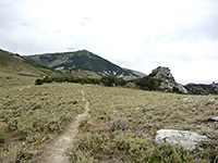
| Sky Line Trail | 1.4 | 600 | The highest trail in the national reserve ascends a ridge on the west side of 8,867 foot Mount Graham, giving unsurpassed views of the granite rocks to the south. The path continues into the adjacent Sawtooth National Forest. Access is via the Indian Grove Trail. |
| Stripe Rock Trail | 3.1 (loop) | 200 | Stripe Rock is a conspicuous formation split by a light-colored volcanic dike, accessible from several trailheads but the usual start point is Circle Creek Overlook, at the end of a narrow side road (no RVs). The path (which is also open to cycles) runs westwards over flat grassland to the start of a loop section; up North Fork Circle Creek a little way, south past the rock then east back into the open area. |
| Tea Kettle Trail | 2.5 | 600 | One of the lesser-used trails in the national reserve, this traverses grassy, partly wooded hillsides, mostly without any granite formations, but good territory for wildlife. |
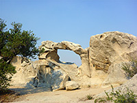
| Window Arch Trail | 0.1 | level | The shortest trail in the national reserve follows a granite ridgetop to a small but photogenic natural arch, surrounded by other eroded formations. Parking for the hike is beside campsite no. 37. |
All Contents © Copyright The American Southwest | Comments and Questions | Contribute | Affiliate Marketing Disclosure | Site Map