Highlights:
Shapely red peaks rising to 14,000 feet, made of thin layered sandstone rather than the granite that makes up most of the Rocky Mountains. Surrounded by craggy slopes, aspen forests and deep valleys sheltering several lakes
Nearest city with chain hotels:
Snowmass, 13 miles
Management:
USFS; part of White River National Forest
Location:
39.097, -106.944 (Maroon Lake)
Seasons:
Late spring, summer, fall
Rating (1-5):
★★★★★
Weather:


Maroon Bells is part of the Colorado Rockies itinerary
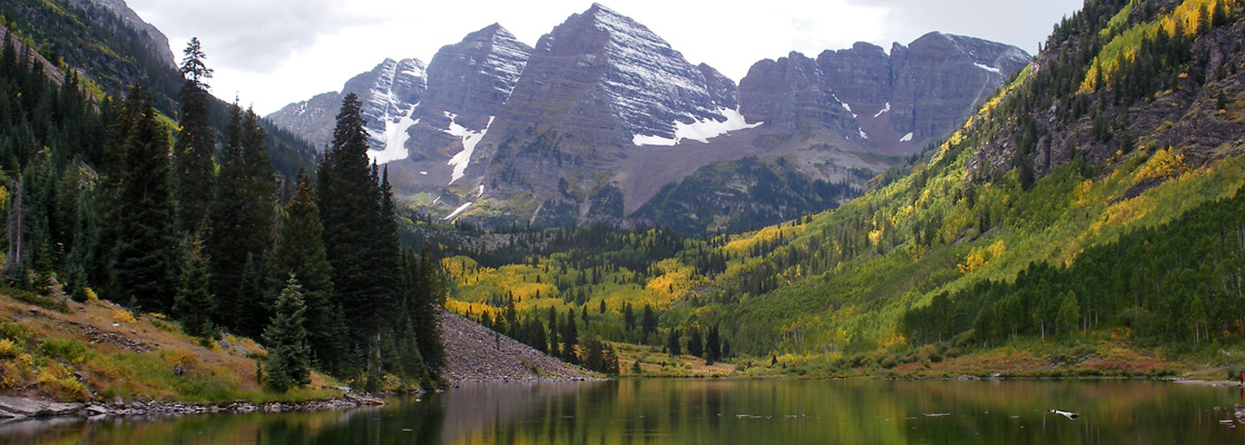
North and South Maroon Peak are two adjacent, 14,000 foot summits at the center of the Elk Mountains in the western Rockies, a few miles from the affluent ski resort town of Aspen, and they form the main attraction of Maroon Bells-Snowmass Wilderness - nearly 300 square miles of rugged mountains, glacial valleys, meadows, forest, lakes, creeks and waterfalls.
Besides their bell shape and deep red color, the peaks and many of the surrounding hills are unusual for being composed of sedimentary rock rather than the predominant limestone and granite that make up most of Colorado's mountains, and the numerous thin, angled layers around the summits are evident even when viewed from a distance, including from the usual vantage point near the head of the narrow valley of Maroon Creek.
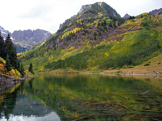
The image of the red, angular mountains reflected in the greenish waters of Maroon Lake and framed by symmetric tree-covered slopes at either side is supposedly the most photographed vista in the state. Because of the area's popularity, a rather high entrance fee is charged ($10 per vehicle in 2024) for the main access road, and the lakeshore is often very busy, but a short hike further up the valley is rewarded by much other photogenic scenery, in the company of far fewer people.
Besides their bell shape and deep red color, the peaks and many of the surrounding hills are unusual for being composed of sedimentary rock rather than the predominant limestone and granite that make up most of Colorado's mountains, and the numerous thin, angled layers around the summits are evident even when viewed from a distance, including from the usual vantage point near the head of the narrow valley of Maroon Creek.
The image of the red, angular mountains reflected in the greenish waters of Maroon Lake and framed by symmetric tree-covered slopes at either side is supposedly the most photographed vista in the state. Because of the area's popularity, a rather high entrance fee is charged ($10 per vehicle in 2024) for the main access road, and the lakeshore is often very busy, but a short hike further up the valley is rewarded by much other photogenic scenery, in the company of far fewer people.
Maroon Bells Table of Contents
- Map of the Maroon Bells
- Photographs
- Orientation
- Approach, along Maroon Creek
- Scenery of the Maroon Bells
- Hiking at the Maroon Bells; Crater Lake Trail
- Nearby places
- Similar places
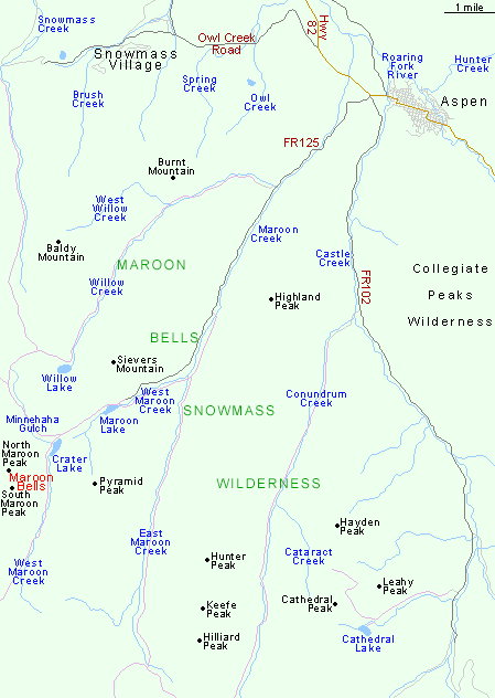
Map of Maroon Bells-Snowmass Wilderness (central area)
Orientation
The Maroon Bells Wilderness area includes a 30 mile section of the Elk Mountains, which although steep and high in elevation are a relatively narrow range, and split by many ravines so the backcountry is quite easy to access. The wilderness is served by over a dozen trailheads and crossed by 100 miles of footpaths; no location is more than 3 miles from a trail. The three main approach roads are on the north side of the mountains (see map), all starting near Aspen - FR 102 up Castle Creek, Owl Creek Road to Snowmass Village, and (by far the most used), FR 125 along Maroon Creek. These last two start just west of Aspen town center, branching off Highway 82 at a recently-built roundabout. Maroon Creek Road first passes a mile of luxurious houses and guest lodges (Aspen Highlands Village) then enters unspoilt woodland - part of the White River National Forest, which extends all across the Maroon Bells Wilderness. The road runs alongside the creek for several miles, and past the USFS entrance station where the fees are collected. But private vehicles can only drive the road in spring/fall as in summer demand is too high and parking insufficient, so all visitors have to travel by shuttlebus, starting at the village. The buses run between 9 am and 5 pm, departing every 20 to 30 minutes.
Maroon Creek
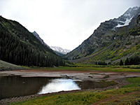
After the entrance station road FR 125 passes three campsites, and the trailhead for the lesser used path up East Maroon Creek (the East Wilderness Portal), before ending at the sizeable parking area for the West Wilderness Portal, at elevation 9,560 feet. Maroon Lake and the famous view of the Maroon Bells are then just a short distance away through a patch of trees - 90% of visitors just walk a few hundred feet around the edge of the lake, to take the famous photograph. The second most popular option is the 0.75 mile Scenic Loop Trail, which starts at the far side of the lake and follows the creek upstream, visiting cascades, a beaver pond and several larger waterfalls. Rather fewer people take the Maroon Creek Trail, a 3.2 mile route that parallels the stream back down to the East Portal. But the main path, leading deep into the backcountry, is TR 1975 to Crater Lake and beyond.
Maroon Bells Scenery
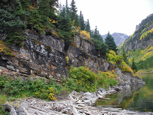
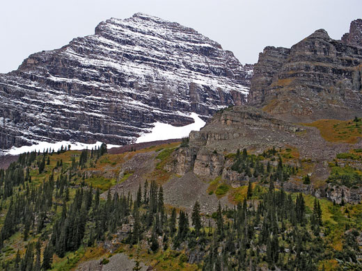
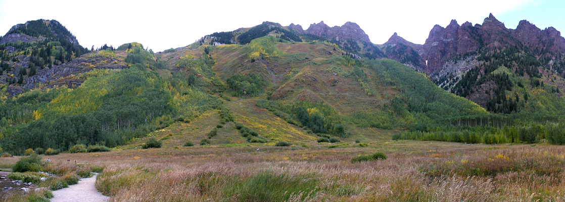
Although Maroon Bells are the most well known summits in view, they are still over 3 miles away; other red hills are much closer, lining both sides of the valley and rising to 12,760 feet (Sievers Mountain) just to the north. The higher peaks bear some snow all year, and massive falls in winter close the access road for several months. The lower slopes also have much exposed rock, plus a mixture of spruce, fir, aspen, bushes and grass, and so take on pleasing yellow-red tints when the leaves turn in fall. Maroon Lake is pretty but quite shallow, its east edge bordered a thick mat of driftwood, and the north end partly filled by verdant green weed. A bridge crosses the inlet stream, at the start of the scenic loop, and the main trail runs along the north side, though the south shore is steeper and less accessible.
Trails of Maroon Bells
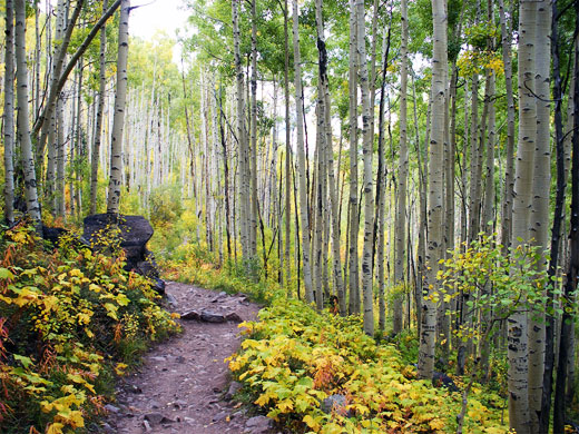
Crater Lake Trail
★★★★★
★★★★★
1.8 miles, 550 feet
This is the shortest path into the Maroon Bells-Snowmass Wilderness, starting beside reflective Maroon Lake and soon reaching Crater Lake after climbing through fir, spruce and aspen forestMaroon Bells - Nearby Places
- Independence Pass (30 miles) - the highest paved mountain pass in Colorado
- Rifle Falls State Park (76 miles) - unusual triple waterfall and a limestone grotto
Maroon Bells - Similar Places
- Rocky Mountain National Park, Colorado - most accessible section of the central Rockies
- San Juan Mountains, Colorado - peaks, canyons, historic towns and old mines
All Contents © Copyright The American Southwest | Comments and Questions | Contribute | Affiliate Marketing Disclosure | Site Map