The Curecanti National Recreation Area map indicates the location of all trails.

Curecanti Trails
|
Crystal Creek Trail Length 1.4 miles (2.3 km) Elevation change 300 feet (91 meters) Trailhead Small parking area alongside Hwy 92 Rating (1-5) ★★★★★ Probably the least used hiking route in the NRA, the Crystal Creek Trail begins along scenic highway 92 and follows a gently ascending ridgeline westwards, to an 8,894 foot summit, high above the middle of Crystal Reservoir. The lower end of the deep, narrow canyon of Crystal Creek can be seen to the north. The path crosses lightly wooded surroundings, good for wildflowers in the summer. |
|
Curecanti Creek Trail Length 1.8 miles (2.9 km) Elevation change 900 feet (274 meters) Trailhead Pioneer Point, along Hwy 92 Rating (1-5) ★★★★★ The Curecanti Creek Trail is the easier of two paths that descend from the north rim of Morrow Point Reservoir all the way to the water's edge. It starts from Pioneer Point along Hwy 92, adjacent to the V-shaped tributary canyon carved by the creek, and is level at first, heading north along the rim, before a couple of short but steep switchbacks down to the streamway, which is crossed twice on bridges. The hike ends beside the flooded lower end of the creek, a little way from the edge of the main reservoir. |
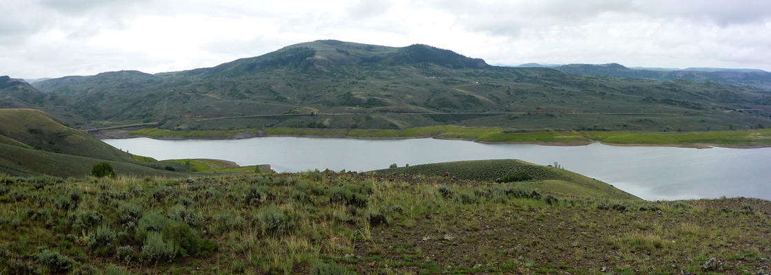
Dillon Pinnacles Trail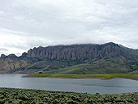 Length 2 miles (3.2 km) Elevation change 300 feet (91 meters) Trailhead Parking area along US 50, by the north end of Middle Bridge Rating (1-5) ★★★★★ Path across sagebrush slopes on the north shore of Blue Mesa Reservoir to the base of a line of volcanic spires along the south edge of Dillon Mesa. The trail also has good views over the lake and the surrounding mountains. |
|
Hermits Rest Trail Length 2.5 miles (4 km) Elevation change 1800 feet (549 meters) Trailhead At the Hermits rest overlook, Hwy 92 Rating (1-5) ★★★★★ The most strenuous of Curecanti's seven maintained trails has expansive views at the start, along the south edge of Cimarron Point, but it soon starts a big descent into the depths of the Gunnison River canyon, following an unnamed, wooded, steeply-sloping drainage to a promontory towards the west end of Morrow Point Reservoir. A campsite and picnic area are located at the end of the trail. |
|
Mesa Creek Trail Length 0.7 miles (1.1 km) Elevation change 50 feet (15 meters) Trailhead End of the short road to Morrow Point Dam, off US 50 Rating (1-5) ★★★★★ This easy path starts from the parking/picnic area at the end of Cimarron Canyon, below Morrow Point Dam; it descends slightly, crosses the Gunnison River on a footbridge and heads downstream a way, over the lower end of Mesa Creek to the base of a cliff that prevents any further travel. This part of the main gorge is particularly narrow. |
|
Neversink Trail Length 0.6 miles (1 km) Elevation change level Trailhead At the Neversink picnic area along US 50 Rating (1-5) ★★★★★ Right at the east edge of the NRA, beyond the upper end of Blue Mesa Reservoir, the Neversink Trail follows the north bank of the Gunnison River for a short distance - overgrown, riparian habitat good for birds and other wildlife. The river splits into several channels, one of which is crossed on a footbridge. |
|
Pine Creek Trail Length 1.2 miles (1.9 km) Elevation change 200 feet (61 meters) Trailhead Along the short side road to Blue Mesa Dam Rating (1-5) ★★★★★ Pine Creek is a small tributary on the south side of the Gunnison River, joining it just below Blue Mesa Dam. The lower end has a few cascades and small waterfalls, viewed from a path which descends via some steps to the edge of the river and follows an old rail bed for one mile westwards. Interpretative notices along the way have information about the history of the railroad. |
All Contents © Copyright The American Southwest | Comments and Questions | Contribute | Affiliate Marketing Disclosure | Site Map