Highlights:
Forest service preserve centered on a major archaeological site from the 11th century, scenically situated on a narrow ridge, beside the jagged pinnacles of Chimney Rock. Accessed on foot, or via free tram along the narrow approach road
Nearby town:
Durango, 47 miles
Management:
Location:
Seasons:
Mid May to the end of September - closed by snow in winter
Rating (1-5):
★★★★★
Weather:


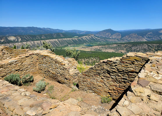
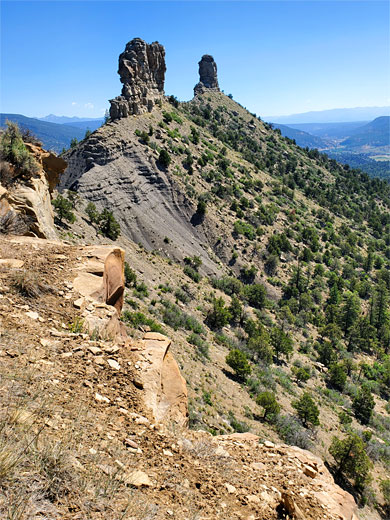
In far south Colorado, 2.5 miles from the New Mexico stateline, Chimney Rock National Monument is a relatively recent preserve, created in 2012, protecting a major archaeological site from the 11th century, scenically situated atop a narrow ridge, which to the east rises to a pair of pinnacle-like summits, Companion Rock and Chimney Rock. There are various rooms, kivas and walls here, the site extending about 1000 feet along the ridgetop, which is 100 feet or less in width, and steep-sided, so the settlement has commanding views over all the surroundings.
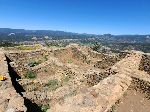
The visible walls are all partially reconstructed, and the tallest is only about 4 feet, so the structures are rather less complete than some other well known pueblos such as at Mesa Verde or Chaco Canyon, but the setting is certainly spectacular.
The national monument is administered by the USFS rather than the NPS, on land of the San Juan National Forest, and is fully open only from mid May to the end of September, being closed by snow at other times, though the ruins are still accessible during winter, on foot, at least in theory. The top of the ridge is reached by a gravel road, 3 miles long, which in the main visitor season is open to private vehicles, however people are encouraged instead to park at the base of the ridge and travel along the road using a free tram service. Also by the main parking place are the visitor center and an amphitheater where talks are sometimes given.
Chimney Rock Table of Contents
- Map of the national monument
- Photographs
- History
- Location
- Exploring the Pueblo
- Nearby places
- Similar places
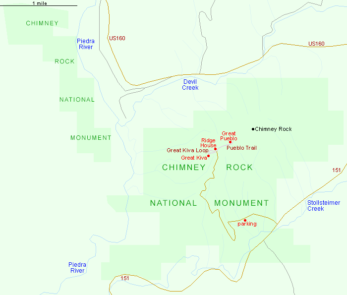
Map of Chimney Rock National Monument
Photographs
29 views of Chimney Rock National Monument.
History of Chimney Rock
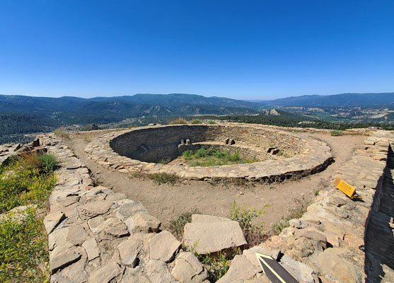
The pueblo at Chimney Rock was occupied by the Ancestral Puebloans, and at its peak was home to maybe 2,000 people, with about 200 rooms plus a number of kivas. The site was established around 925 and reached its final size in 1070s, when the Great Pueblo was constructed, this consisting of two kivas and 36 rooms, and today this constitutes the largest section of the visible ruins. Also around this time, 1084, the largest kiva, the Great Kiva, was added, but the inhabitants did not stay at the site too much longer, abandoning the area in 1125 for reasons that are unclear. Much of the Chimney Rock pueblo is yet to be fully excavated, and elsewhere in the monument are various other, smaller ancient settlements, generally not open to the public. The main component of the monument is the large section enclosing Chimney Rock; there is also a detached area to the northwest containing another ridge, larger and wider, with more unexcavated sites.
Location
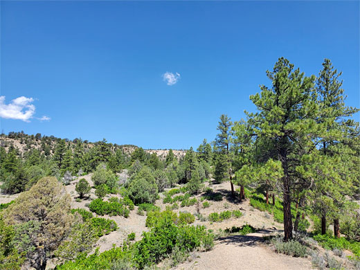
Chimney Rock is bordered by three watercourses, the Piedra River to the west, the largest, the Stollsteimer Creek to the south, followed by Hwy 151, and Devil Creek to the north, along which runs the major route US 160. The short side road to the monument forks off Hwy 151, passes the visitor center and parking place then climbs 900 feet up the hillside, to a smaller parking area by the ruins. Most visitors see only the pueblo site, which is toured by two short trails; there is also one other path, a nature trail, a one mile loop, that starts from the visitor center and climbs a little way up the side of the ridge to a viewpoint amidst pine woodland, looking south across the Stollsteimer River valley.
Exploring the Pueblo
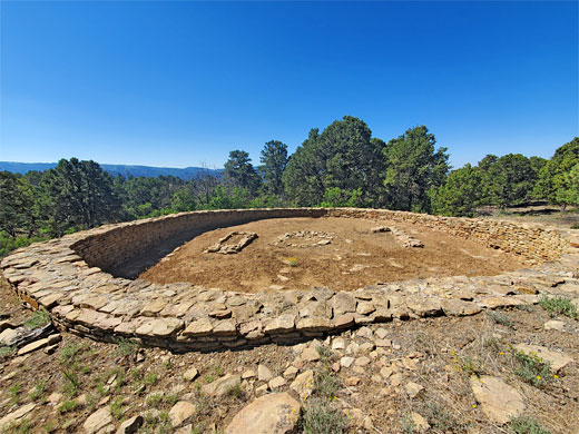
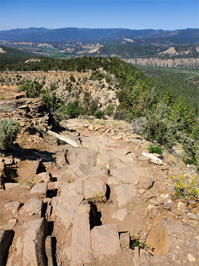
Two paths start from the upper parking area. To the west is the Great Kiva Trail, a paved, 0.3 mile loop, that passes the eponymous kiva, which is 50 feet in diameter, and also a stone basin, and a circular pit house, one of several in the vicinity, the others being unexcavated. The surroundings are sagebrush and pinion/juniper pines, here at an elevation of 7,400 feet, and the bedrock, exposed in various places, is orange-red sandstone from the Picture Cliffs Formation. The second path, the Chimney Rock Trail, 0.6 mile one-way, heads east along the narrow ridge, climbing quite steeply at first, rising 200 feet and levelling out as it reaches the Great Pueblo, on the way passing various other excavated remains. The pueblo has about 20 main rooms and two kivas, and the walls, in some places, extend right to the edge of the ridgetop. A park ranger is usually present during opening hours, to answer questions, stop people walking on the walls, and also to stop people hiking further east, along a largely disused path that leads to the base of the Chimney Rock summit. There is one other group of structures, right by the parking area; this is Ridge House, also partly reconstructed, with three circular rooms and several wall sections.
Chimney Rock - Nearby Places
- Mesa Verde National Park (95 miles) - the most famous ancient sites in the Southwest
- Navajo Lake State Park, New Mexico (60 miles) - large, branched artificial lake along the San Juan River
Chimney Rock - Similar Places
- Bandelier National Monument, New Mexico - unusual cliff dwellings and ruins in a volcanic canyon
- Walnut Canyon National Monument, Arizona - cliff dwellings in a steep canyon
All Contents © Copyright The American Southwest | Comments and Questions | Contribute | Affiliate Marketing Disclosure | Site Map