Videos of California
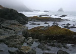 The rough, rocky, foggy coastline just south of Enderts Beach, at the edge of Del Norte Coast Redwoods State Park, in north California. South of this point, all of the shoreline is quite inaccessible, due to the very steep cliffs. (0:28 min; 5.6 mb) |
 Six short scenes of waves breaking over jagged sandstone rocks along the Pacific coast in Harmony Headlands State Park, between Morro Bay and Cambria. The rocks range in color from black in the tidal zone to orange above the high water line, and many have the unusual weathering texture known as tafoni. (0:48 min; 33 mb) |
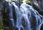
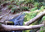 Pools and cascades of Fern Falls, at the end of the 2.6 mile Boy Scout Tree Trail in Jedediah Smith Redwoods State Park. This location is just a quarter of a mile from the edge of the woods, so receives a little more sunlight hence the understory vegetation is denser and more varied than places deeper in the forest. (0:50 min) |
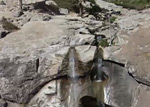
 Ella Falls is a small waterfall formed by Sequoia Creek as it flows down a steep granite hillside in the Grant Grove section of Kings Canyon National Park, reached by a 1.5 mile walk along the Sunset Trail starting from the Sunset Campground, or a slightly longer walk from the General Grant Tree. (0:31min; 6.1 mb) |
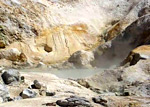 Some of the active geothermal features of Bumpass Hell in Lassen Volcanic National Park, including the largest hot spring in the basin (East Pyrite Pool), and the world's hottest fumarole (Big Boiler). (0:45 min; 9 mb) |
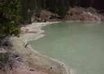 Boiling Springs Lake, in the Warner Valley section of Lassen Volcanic National Park: the lake itself, and several mud pots and vents around the edges. (0:56 min; 14 mb) |
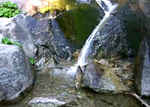
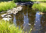 Reached by a 0.8 mile trail starting at the Kings Creek picnic area, Cold Boiling Lake is surrounded by trees and marshy grassland, with several small satellite pools, some of which bubble gently due to escaping carbon dioxide gas. (0:19 min; 3.6 mb) |
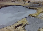 Devils Kitchen is a colorful group of hot springs, mud pots and fumaroles, along Hot Springs Creek in the Warner Valley section of Lassen Volcanic National Park. (1:15 min; 18 mb) |
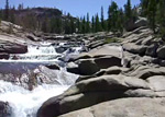
 Eight short scenes of the cascades and falls along Kings Creek, reached by a 1.5 mile trail starting half way along the scenic drive (CA 89) through Lassen Volcanic National Park. (1:28 min; 17.4 mb) |
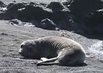 Several scenes of harbor seals on the black sand beach near Punta Gorda Lighthouse, along the Lost Coast of north California. This location is about 3 miles south of Mattole Beach, which is the start point for the 24 mile trail to Shelter Cove towards the south end of the coast. (mp4; 1:04 min; 12.2 mb). |
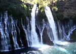 The segmented, 100 foot cascades of Burney Falls - the main attraction of McArthur-Burney Falls Memorial State Park in north California. Below the falls is a deep, blue pool, from where Burney Creek flows one more mile before joining Lake Britton (0:39 min; 7.6 mb). |
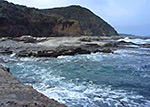 Three brief scenes showing waves breaking over eroded, thin-layered rocks in Montaña de Oro State Park, along the Pacific coast south of Morro Bay. This location is near Hazard Reef, the northernmost section of the rocky coast in the park; beyond this the shoreline is sandy (0:48 min; 22 mb). |
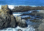
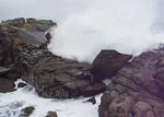 Fierce waves breaking over the eroded sandstone rocks in the northern part of Salt Point State Park, on the Pacific coast of Sonoma County, north California (1:26 min; 21.6 mb) |
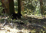 This short, shaky video shows a young black bear scratching against a tree, at the edge of a meadow alongside the Sunset Rock Trail, in the Giant Forest area of Sequoia National Park (0:18 min; 3.2 mb) |
 Scenes around Chilnualna Falls, southwest Yosemite National Park: pools and small cascades along Chilnualna Creek just above the cliff edge, the falls themselves seen from a small summit opposite, pools and narrow channels further upstream, and a larger pool at the base of granite cliffs. (1:53 min; 16.8 mb) |
 Seven scenes of the Tuolumne River, towards the west end of the Glen Aulin Trail from Tuolumne Meadows to the Glen Aulin campsite, Yosemite National Park: cascades leading to two large pools, the brink of Tuolumne Falls, cliffs around Tuolumne Falls, a pool beneath Tuolumne Falls, more cascades just downstream of Tuolumne Falls, and finally two views of White Cascade. (1:34 min; 18.2 mb) |
All Contents © Copyright The American Southwest | Comments and Questions | Contribute | Affiliate Marketing Disclosure | Site Map